Before the current bridges crossing the Rouge River at West Jefferson and Fort Streets were built, the two crossings were served by narrow swing bridges.[3] By the late 1910s, these spans urgently needed replacing, in large part because they interfered with the Federal government's plans to dredge the Rouge River to provide freighter access to the Ford River Rouge Complex. Both the city of Detroit (who was responsible for maintaining the bridges) and Wayne County agreed that the county could better oversee the construction, but legal restrictions prohibited county involvement until state law was changed in 1919.[3]
With the new legislation in place, plans were drawn up in 1920 for a "Chicago city type of single trunnion, double-leaf bascule bridge" for each bridge.[3] This design, prototyped by the 1902 Cortland Street Drawbridge, is optimized for tight spaces, and features a hidden counterweight that descends into a pit when the bridge opens.[4]
The cost for the pair of bridges was estimated at $2 million.[3] A bond issue to fund construction was approved by Wayne County voters, and an alternate route onto which Jefferson Avenue traffic could be shunted was devised. Wayne County obtained an old truss, originally used by the Michigan Central Railroad upstream of Jefferson, and floated it downstream to a location 200 yards north of Jefferson.[3] The old Jefferson Avenue bridge was closed and the detour opened on November 13, 1920.[3]
Construction on the bridge commenced immediately. Each leaf was to be supported by four 12-foot-square concrete footings, sunk to the bedrock 70 feet (21m) below the water line. The footings supported a concrete pit measuring 50 by 80 feet (24m) which housed the counterweights and machinery.[3] Wayne County contracted with the Missouri Valley Bridge and Iron Company of Leavenworth, Kansas, to build the substructure for $408,280; with the Strobel Steel Construction Company of Chicago to build the superstructure for $378,005; Cooper-Widenmann Construction Company of Detroit to build the operators' houses for $78,700; and Fowler Electrical Supply Company of Toledo, Ohio, to supply electrical equipment for $34,809.[3] County crews graded and paved the approaches.
On August 21, 1922, the two bascule leaves were lowered simultaneously for the first time. The bridge was opened to traffic on October 17; at the time, work on the approaches was still ongoing, but operating machinery on the detour bridge failed, necessitating the bridge's removal to allow free passage of river traffic. The next year, the federal government completed its planned dredging of the Rouge River.[3]
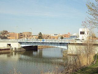
In the early 1980s, the county spent $2.2 million to repair portions of the West Jefferson Bridge (as well as doing similar work to the crossing at Dix Avenue). These repairs have somewhat altered the West Jefferson Bridge, but it retains its integrity as a significant example of early twentieth-century engineering.[3] The bridge was listed on the National Register of Historic Places in 2000, as part of a Multiple Property Submission of historic highway bridges in the state of Michigan.[2]
The West Jefferson Avenue bridge was hit by the lake freighter Herbert C. Jackson in the early morning of May 12, 2013, causing significant damage to the bridge. The bridge operator on duty was heavily intoxicated, and rapidly closed the bridge after opening it and signalling for the freighter to proceed. The Herbert C. Jackson, loaded with iron ore bound for the Rouge Steel plant, dropped its anchors and reversed its engines, but could not stop in time.[5]
The bridge was damaged severely in the 2013 incident, which was technically an allision. The Herbert C. Jackson suffered only minor damage, and there were no injuries aboard the freighter or on shore.[5] The bridge operator, a 17-year employee of the Wayne County Road Commission, was fired and ordered to pay a $1,000 fine, but was not otherwise criminally charged. The bridge was closed to road traffic for over three years while repairs were made, to the displeasure of city leaders in River Rouge, who criticized Wayne County officials for inaction.[6] The bridge reopened on August 12, 2016, at a cost of over $20 million,[6] the majority of which was covered by insurance.[7]
Wayne County is the most populous county in the U.S. state of Michigan. As of 2020, the United States census placed its population at 1,793,561, making it the 19th-most populous county in the United States. The county seat is Detroit. The county was founded in 1796 and organized in 1815. Wayne County is included in the Detroit-Warren-Dearborn, MI Metropolitan Statistical Area. It is one of several U.S. counties named after Revolutionary War-era general Anthony Wayne.
A bascule bridge is a moveable bridge with a counterweight that continuously balances a span, or leaf, throughout its upward swing to provide clearance for boat traffic. It may be single- or double-leafed.
The Zilwaukee Bridge is a high-level, segmental concrete bridge spanning the Saginaw River in the U.S. state of Michigan. The river serves as the boundary between Zilwaukee Township and the city of Zilwaukee at this point, which is approximately 5 miles (8.0 km) north of downtown Saginaw. It carries Interstate 75 and US 23.
Interstate 675 (I-675) is an auxiliary Interstate Highway in the US state of Michigan. The freeway is a 7.7-mile-long (12.4 km) loop route through downtown Saginaw, as I-75 passes on the east side of the city. I-675 is also a state trunkline highway that provided a bypass of the former drawbridge carrying I-75 and US Highway 23 (US 23) across the Saginaw River. Construction of I-675 started in 1969 and the freeway opened in 1971. Since then, sections near downtown were reconstructed between 2009 and 2011 to update one of the freeway's interchanges and rebuild the bridge over the Saginaw River.
This is a list of properties on the National Register of Historic Places in the U.S. state of Michigan. This National Park Service list is complete through NPS recent listings posted January 24, 2025.
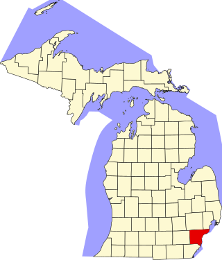
This is a list of the National Register of Historic Places listings in Wayne County, Michigan.
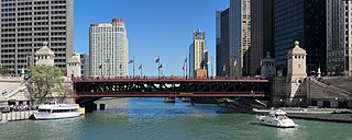
The DuSable Bridge is a bascule bridge that carries Michigan Avenue across the main stem of the Chicago River in downtown Chicago, Illinois, United States. The bridge was proposed in the early 20th century as part of a plan to link Grant Park (downtown) and Lincoln Park (uptown) with a grand boulevard. Construction of the bridge started in 1918, it opened to traffic in 1920, and decorative work was completed in 1928. The bridge provides passage for vehicles and pedestrians on two levels. An example of a fixed trunnion bascule bridge, it may be raised to allow tall ships and boats to pass underneath. The bridge is included in the Michigan–Wacker Historic District and has been designated as a Chicago Landmark.
The Glimmer Glass Bridge is a county owned bridge in Monmouth County, New Jersey, United States. It carries traffic from Brielle Road over the Glimmer Glass, a navigable tidal inlet of the Manasquan River, between Manasquan and Brielle. It has also been on the National Register of Historic Places, since 2008. Due to its age, Commercial vehicles cannot be driven over it. It also allows Bicycles and pedestrians to walk on the wooden sidewalk.
The Cortland Street Drawbridge over the Chicago River is the original Chicago-style fixed-trunnion bascule bridge, designed by John Ericson and Edward Wilmann. When it opened in 1902, on Chicago's north side, it was the first such bridge built in the United States. The bridge was a major advance in American movable bridge engineering, and was the prototype for over 50 additional bridges in Chicago alone. The bridge was designated as an ASCE Civil Engineering Landmark in 1981, and a Chicago Landmark in 1991.
The Lafayette Avenue Bridge, formerly listed on the National Register of Historic Places as the Bay City Bascule Bridge, is the name given to two separate bridges located in Bay City, Michigan. The bridges carry M-13 and M-84 over the Saginaw River. They are maintained by the Michigan Department of Transportation, and the bascule portion is currently the oldest of Bay City's four modern drawbridges. It was listed on the National Register of Historic Places on November 30, 1999, but was removed from the Register in 2015.
This is a list of the National Register of Historic Places listings in Detroit, Michigan.
The Fort Street–Pleasant Street and Norfolk & Western Railroad Viaduct is a bridge carrying six lanes of Fort Street over both Pleasant Street and multiple tracks comprising the Norfolk Southern Railway Detroit District and Conrail Shared Assets Lincoln Secondary and Junction Yard Secondary lines on the border of the Boynton and Oakwood Heights neighborhoods in Detroit, Michigan, just west of the Rouge River. It was listed on the National Register of Historic Places in 2000. The bridge underwent massive repairs and other construction in late 2010 and throughout much of 2011, which included narrowing the Fort Street boulevard north of the viaduct into a six-lane undivided road with a left-turns-only lane. The bridge was removed from the NRHP in 2022.
The Jefferson Avenue–Huron River and Harbin Drive–Silver Creek Canal Bridges are two separate bridges, sharing a continuous railing, that were jointly listed on the National Register of Historic Places on February 10, 2000.
This is a list of the National Register of Historic Places listings in Downtown and Midtown Detroit, Michigan. It is intended to be a complete list of the properties and districts on the National Register of Historic Places in Downtown and Midtown neighborhoods in Detroit, Michigan, United States. Latitude and longitude coordinates are provided for many National Register properties and districts; these locations may be seen together in online maps.
The Cheboygan Bascule Bridge, also known as the State Street Bridge, is a double-leaf bascule bridge in Cheboygan, Michigan, carrying U.S. Highway 23 across the Cheboygan River. Built in 1940, it was the last bascule bridge constructed in the state of Michigan prior to the end of World War II. It replaced an aging swing bridge built in 1877. The bridge is listed on the National Register of Historic Places.
The Winant Avenue Bridge is a vehicular movable bridge spanning the Hackensack River in Bergen County, New Jersey 14 miles (23 km) from its mouth at Newark Bay. Built in 1934, it is also known as the Route 46 Hackensack River Bridge and S46 Bridge, it carries U.S. Route 46 (US 46) in Little Ferry and Ridgefield Park. Owned and operated by the New Jersey Department of Transportation (NJDOT), the double leaf bascule bridge is located on a navigable reach. While there have been no requests since 1978, the Code of Federal Regulations last amended in 1999 requires 24-hour notice to be opened. The bridge has been minimally altered since its construction and is eligible for individual listing on the National Register of Historic Places (NRHP).
Eighth Street Bridge is a road bridge over the Passaic River in northeastern New Jersey, United States. It connects the City of Passaic in Passaic County with the Borough of Wallington in Bergen County and is jointly owned by both counties. The bridge connects Eighth Street in Passaic with County Route 507 in Wallington.
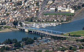
The San Leandro Bay Bridge, better known as the Bay Farm Island Bridge, is a single-leaf bascule drawbridge spanning the San Leandro Channel, the inlet of San Leandro Bay within the San Francisco Bay Area, California, United States. It carries California State Route 61 and links the main island of Alameda with Bay Farm Island within the city of Alameda. The present bridge was completed in 1953; it is paralleled by a second bridge devoted to pedestrian and bicycle traffic, the Bay Farm Island Bicycle Bridge.
The Seventh Street–Black River Bridge is a bridge carrying Seventh Street over the Black River in Port Huron, Michigan. The bridge was listed on the National Register of Historic Places in 2000. It is the only single-leaf bascule bridge in the state of Michigan.
This page is based on this Wikipedia article Text is available under the CC BY-SA 4.0 license; additional terms may apply. Images, videos and audio are available under their respective licenses.