West Kootenai, Montana

Last updated

West Kootenai, Montana
USA Montana location map.svg
Red pog.svg
West Kootenai
Location of West Kootenai, Montana
Usa edcp location map.svg
Red pog.svg
West Kootenai
West Kootenai (the United States)
Coordinates: 48°57′47″N115°13′9″W / 48.96306°N 115.21917°W / 48.96306; -115.21917
Country United States
State Montana
County Lincoln
Area
[1]
  Total16.14 sq mi (41.79 km2)
  Land16.07 sq mi (41.63 km2)
  Water0.06 sq mi (0.16 km2)
Elevation
2,780 ft (850 m)
Population
 (2020)
  Total422
  Density26.25/sq mi (10.14/km2)
Time zone UTC-7 (Mountain (MST))
  Summer (DST) UTC-6 (MDT)
Area code 406
FIPS code 30-79105
GNIS feature ID2583864 [2]

West Kootenai is a census-designated place (CDP) in Lincoln County, Montana, United States. The population was 365 at the 2010 census. [3]

Contents

Boarding School

The West Kootenai was the location for an all-boys boarding school due to its remote location. It is now closed.

Geography

West Kootenai is in northern Lincoln County, Montana on the west side of Lake Koocanusa, a large reservoir on the Kootenai River. The community is within the Kootenai National Forest. The northern boundary of the CDP is the Canada–United States border, with the Regional District of East Kootenay, British Columbia, to the north. There is no border crossing through West Kootenai; road access is from the south via West Kootenai Road. The city of Eureka, Montana, 11 miles (18 km) to the southeast as the crow flies, is 30 miles (48 km) distant by road.

According to the U.S. Census Bureau, the West Kootenai CDP has a total area of 16.1 square miles (41.8 km2), of which 16.1 square miles (41.6 km2) are land and 0.1 square miles (0.2 km2), or 0.46%, are water. [4]

Demographics

Historical population
CensusPop.Note
2020 422
U.S. Decennial Census [5]

Lakes

There are a few named lakes in the West Kootenai. Along West Kootenai Road is Tooley Lake and further down is Alkali Lake accessed via dirt road.

See also

Related Research Articles

<span class="mw-page-title-main">Lincoln County, Montana</span> County in Montana, United States

Lincoln County is a county located in the U.S. state of Montana. As of the 2020 census, the population was 19,677. Its county seat is Libby. The county was founded in 1909 and named for President Abraham Lincoln. The county lies on Montana's north border and thus shares the US-Canadian border with the Canadian province of British Columbia.

<span class="mw-page-title-main">Big Arm, Montana</span> Census-designated place in Montana, United States

Big Arm is a census-designated place (CDP) in Lake County, Montana, United States. The population was 177 at the 2010 census, up from 131 in 2000.

<span class="mw-page-title-main">Charlo, Montana</span> Census-designated place in Montana, United States

Charlo is an unincorporated community and census-designated place (CDP) in Lake County, Montana, United States. The population was 379 at the 2010 census, down from 439 in 2000. The 2018 population estimate was 320.

<span class="mw-page-title-main">Finley Point, Montana</span> Census-designated place in Montana, United States

Finley Point is a census-designated place (CDP) in Lake County, Montana, United States. As of the 2010 census the population was 480.

<span class="mw-page-title-main">Kicking Horse, Montana</span> Census-designated place in Montana, United States

Kicking Horse is a census-designated place (CDP) in Lake County, Montana, United States. The population was 286 at the 2010 census, up from 80 in 2000.

<span class="mw-page-title-main">Ravalli, Montana</span> Place in Montana, United States

Ravalli is an unincorporated community in Lake County, Montana, United States. The population was 76 at the 2010 census, down from 119 in 2000. For statistical purposes, the United States Census Bureau has defined Saticoy as a census-designated place (CDP). In the early 1900s, the Pablo-Allard herd in Ravalli was said to be the largest collection of the bison remaining in the U.S. and played a critical role in the conservation of bison.

<span class="mw-page-title-main">Rocky Point, Montana</span> Census-designated place in Montana, United States

Rocky Point is a census-designated place (CDP) in Lake County, Montana, United States. The population was 97 at the 2010 census.

<span class="mw-page-title-main">Turtle Lake, Montana</span> Census-designated place in Montana, United States

Turtle Lake is a census-designated place (CDP) in Lake County, Montana, United States. The population was 209 at the 2010 census.

<span class="mw-page-title-main">Helena Valley Northeast, Montana</span> Census-designated place in Montana, United States

Helena Valley Northeast is a census-designated place (CDP) in Lewis and Clark County, Montana, United States. The population was 2,995 at the 2010 census. It is part of the Helena Micropolitan Statistical Area.

<span class="mw-page-title-main">Helena Valley West Central, Montana</span> Census-designated place in Montana, United States

Helena Valley West Central is a census-designated place (CDP) in Lewis and Clark County, Montana, United States. The population was 7,883 at the 2010 census. It is part of the Helena Micropolitan Statistical Area.

<span class="mw-page-title-main">Lincoln, Montana</span> Census-designated place in Montana, United States

Lincoln is an unincorporated community and census-designated place (CDP) in Lewis and Clark County, Montana, United States. As of the 2010 census, the population was 1,013.

<span class="mw-page-title-main">Fortine, Montana</span> Census-designated place in Montana, United States

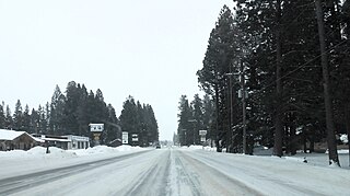
Fortine is a census-designated place (CDP) in Lincoln County, Montana, United States. The population was 206 at the 2021 census.

<span class="mw-page-title-main">Dayton, Montana</span> Census-designated place in Montana, United States

Dayton is an unincorporated community and census-designated place (CDP) in Lake County, Montana, United States. The population was 84 at the 2010 census.

<span class="mw-page-title-main">Pablo, Montana</span> Census-designated place in Montana, United States

Pablo is a census-designated place (CDP) in Lake County, Montana, United States. The population was 2,254 at the 2010 census, up from 1,814 in 2000. It is the home of Salish Kootenai College and the seat of government of the Flathead Indian Reservation.

<span class="mw-page-title-main">Stryker, Montana</span> Census-designated place in Montana, United States

Stryker is an unincorporated community and census-designated place (CDP) in Lincoln County, Montana, United States. As of the 2010 census it had a population of 26. Stryker has the 59933 ZIP code.

<span class="mw-page-title-main">Newcastle (CDP), Maine</span> Census-designated place in Maine, United States

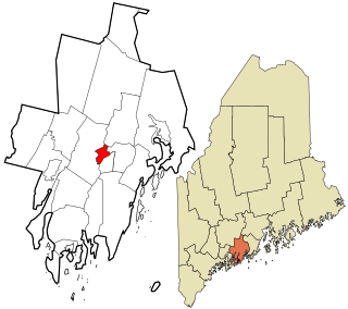
Newcastle is a census-designated place (CDP) comprising the main village of the town of Newcastle in Lincoln County, Maine, United States. The population was 667 at the 2010 census, out of 1,752 in the entire town. In the 2000 census, the village was part of the Damariscotta-Newcastle CDP.

Happys Inn is a census-designated place (CDP) in Lincoln County, Montana, United States. The population was 164 at the 2010 census.

Pioneer Junction is a census-designated place (CDP) in Lincoln County, Montana, United States. The population was 959 at the 2010 census.

Sylvanite is a census-designated place (CDP) in Lincoln County, Montana, United States. The population was 103 at the 2010 census.

White Haven is an unincorporated community and census-designated place (CDP) in Lincoln County, Montana, United States. The population was 577 at the 2010 census.

References

  1. "ArcGIS REST Services Directory". United States Census Bureau. Retrieved September 5, 2022.
  2. U.S. Geological Survey Geographic Names Information System: West Kootenai, Montana
  3. "Total Population: 2010 Census DEC Summary File 1 (P1), West Kootenai CDP, Montana". data.census.gov. U.S. Census Bureau. Retrieved April 30, 2020.
  4. "U.S. Gazetteer Files: 2019: Places: Montana". U.S. Census Bureau Geography Division. Retrieved April 30, 2020.
  5. "Census of Population and Housing". Census.gov. Retrieved June 4, 2016.