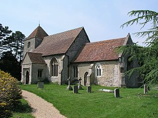
Calverton is a civil parish in the unitary authority area of the City of Milton Keynes, Buckinghamshire, England and just outside the Milton Keynes urban area, situated roughly 1 mile (1.6 km) south of Stony Stratford, and 4 miles (6.4 km) west of Central Milton Keynes. The parish consists of one village, Lower Weald, and two hamlets, Upper Weald and Middle Weald. Lower Weald is the largest of the three settlements, and Manor Farm, the parish church and the former parochial school are within its boundaries.
Brislington is an area in the south east of the city of Bristol, England. It is on the edge of Bristol and 10 miles (16 km) from Bath. Brislington Brook runs through the area in the woodlands of Nightingale Valley and St Anne's Wood. Brislington formerly housed the HTV West Studios on Bath Road, and this is situated next to the historic Arnos Vale Cemetery. Other notable landmarks include Brislington House and the 15th-century St Luke's Church. During the 18th–19th century, Brislington was regarded as a picturesque country village and contained many country homes.

Tormarton is a village and civil parish in the South Gloucestershire district, in the ceremonial county of Gloucestershire, England. The village is about half a mile north of the M4 motorway; the A46 road towards Bath passes a similar distance west of the village to join the motorway at junction 18. The parish includes the small village of West Littleton, south of the motorway. The parish population at the 2021 census was 323. The Cotswold Way footpath passes through the village.

Leigh Delamere is a small village in the civil parish of Grittleton in the English county of Wiltshire, about 4 miles (6 km) northwest of the town of Chippenham. The M4 motorway passes some 250 metres to the south, and the motorway's Leigh Delamere services lie to the east of the village.

Little Barrington is a village and former civil parish, now in the parish of Barrington, in the Cotswold district of Gloucestershire, England. It lies on the south bank of the River Windrush, 3 miles (4.8 km) west of the town of Burford. In 1931 the parish had a population of 84.

Saxlingham is a village and former civil parish, now in the parish of Field Dalling, in the North Norfolk district, in the county of Norfolk, England. It lies 13 miles (21 km) west of Cromer, 26 miles (42 km) north-west of Norwich, 3.6 miles (5.8 km) west of the town of Holt and 126 miles (203 km) north-east of London. In 1931 the parish had a population of 122.

West End is a village and civil parish in Surrey Heath, Surrey, England, approximately 25 miles (40 km) southwest of central London. It is midway between the towns of Camberley and Woking, 4 mi (6.4 km) to the west and east respectively. The River Bourne rises from its sources to the immediate west to run through the village. Until the mid 20th century, the West End consisted of a collection of smallholdings surrounded by a substantial area of common land
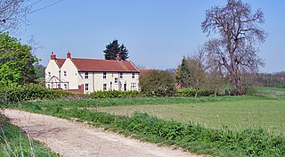
Wauldby is a region in the Yorkshire Wolds within the civil parish of Welton in the East Riding of Yorkshire, England. It contains the gentrified hamlet around Wauldby Manor Farm, and a few other minor dwellings including Little Wauldby Farm.

Flaxley is a small settlement and former civil parish, now in the parish of Blaisdon, in the Forest of Dean, Gloucestershire, England. It is located in between the larger villages of Westbury-on-Severn and Mitcheldean. In 1931 the parish had a population of 87.

Blackford is a village and former civil parish in the county of Somerset, England, beside the A303 road, 4 miles (6.4 km) south west of Wincanton. There are two other places called Blackford in Somerset: one is a village near Wedmore, the other a tiny hamlet in Selworthy parish between Porlock and Minehead.

Ditteridge is a village in the civil parish of Box, Wiltshire, England. It is about 0.8 miles (1.3 km) northwest of Box village and 3.5 miles (6 km) west of the town of Corsham. Formerly a larger settlement, it has an early Norman church and had its own civil parish for a time in the 19th century.
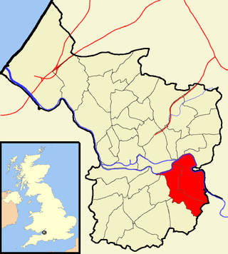
Great Chishill is a village and former civil parish, now in the parish of Great and Little Chishill, in the South Cambridgeshire district, in the county of Cambridgeshire, England. The village is about 1 mile (1.6 km) east of the county boundary with Hertfordshire and about 4 miles (6 km) east of Royston. In 1961 the parish had a population of 293. The 2011 Census recorded Great and Little Chishill's population as 678.

Froxfield Green is a village in the civil parish of Froxfield and Privett, in the East Hampshire district of Hampshire, England. It is 3 miles (5 km) north-west of Petersfield, and lies just north of the A272 road.

Merther is a small hamlet and former civil parish, now in the parish of St Michael Penkevil, in the Cornwall district, in the ceremonial county of Cornwall, England. It lies 2 miles (3 km) east of Truro, on the eastern side of the Tresillian River. In 1931 the parish had a population of 150. It was formerly the churchtown of the small parish of Merther, and also the site of a manor house and medieval chapel dedicated to St Cohan. The former parish church is now in ruins.
Little Chishill is a village and former civil parish, now in the parish of Great and Little Chishill, in the South Cambridgeshire district, in the county of Cambridgeshire, England. It is 1 mile (1.6 km) south of the village of Great Chishill. In 1961 the parish had a population of 86. On 1 April 1968 the parish was abolished to form "Great and Little Chishill".

Burnett is a small village within the civil parish of Compton Dando, approximately 500 metres (1,600 ft) from the River Chew in the Chew Valley within the unitary authority area of Bath and North East Somerset in Somerset, England. The nearest town is Keynsham, which lies approximately 3 miles (4.8 km) north of the village. The parish had an acreage of 608 acres (246 ha). It is within the Bristol/Bath Green Belt.

Rollestone is a small village and former civil parish, now in the parish of Shrewton, on Salisbury Plain, in Wiltshire, England. It is near the River Till. Its nearest town is Amesbury, about 5 miles (8.0 km) away to the east.

Kellaways, also known as Tytherton Kellaways, is a village and former ecclesiastical parish in the present-day civil parish of Langley Burrell Without and ceremonial county of Wiltshire, England. Its nearest town is Chippenham, which lies 2.5 miles (4.0 km) southwest from the hamlet. Historically, the name was sometimes given as Gallows.

Boscombe is a small village and former civil parish, now in the parish of Allington, Wiltshire, England. It lies about 3 miles (5 km) southeast of Amesbury on the banks of the River Bourne, on the A338 road which follows the Bourne on its way from Salisbury to Tidworth and beyond.

Tidmington is a village and civil parish in the Stratford-on-Avon District of Warwickshire, England. It is 11 miles (18 km) south from the town of Stratford-upon-Avon, and at the extreme southern edge of the county bordering Gloucestershire. Within the parish is the Grade II* listed c.1600 Tidmington House, and the Grade II* early 13th-century church of unknown dedication. At the 2001 Census, which for statistical purposes now includes the neighbouring parish of Burmington, the combined population was 153.