Vermilion County is a county in the eastern part of the U.S. state of Illinois, between the Indiana border and Champaign County. It was established in 1826 and was the 45th of Illinois' 102 counties. According to the 2010 United States Census, it had a population of 81,625, a decrease of 2.7% in 2000. It contains 21 incorporated settlements; the county seat and largest city is Danville.

Piatt County is a county in Illinois. According to the 2010 United States Census, it had a population of 16,729. Its county seat is Monticello.

Hardin County is a county located in the U.S. state of Illinois. According to the 2010 census, it has a population of 4,320, making it the least populous county in Illinois. Its county seat is Elizabethtown. Hardin County is located in the part of the state known as Little Egypt. Hardin County was named for Hardin County, Kentucky, which was named in honor of Colonel John Hardin, an officer in the American Revolutionary War and the Northwest Indian War.

Franklin County is a county located in the U.S. state of Illinois. According to the 2010 census, it has a population of 39,561. Its county seat is Benton. It is located in the southern portion of Illinois known locally as "Little Egypt".

Burr Ridge is a suburb of Chicago, in Cook and DuPage counties, Illinois, United States. The village is listed among the top wealthiest towns in Illinois and is locally known for its large beautiful residences. The population was 10,559 at the 2010 census.
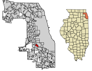
Chicago Ridge is a village in Cook County, Illinois, United States. The population was 14,305 at the 2010 census.

Park Ridge is a city in Cook County, Illinois, United States, and a Chicago suburb. The population was 37,494 at the 2017 census. It is located 15 miles (24 km) northwest of downtown Chicago. It is close to O'Hare International Airport, major expressways, and rail transportation. It is a part of the Chicago metropolitan area, bordering three northwestern neighborhoods of Chicago's Far North Side
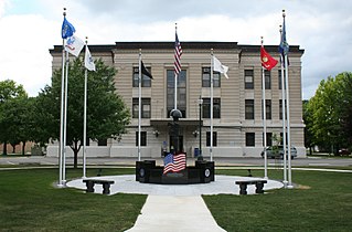
Ridge Farm is a village in Elwood Township, Vermilion County, Illinois, United States. It is part of the Danville, Illinois Metropolitan Statistical Area. The population was 912 at the 2000 census.

West Ridge is one of 77 Chicago community areas. It is a middle-class neighborhood located on the far North Side of the City of Chicago. It is located in the 50th Ward and the 40th Ward. Also historically called North Town, and frequently referred to as West Rogers Park, it is bordered on the north by Howard Street, on the east by Ridge Boulevard, Western Avenue, and Ravenswood Avenue, the south by Bryn Mawr Avenue and Peterson Avenue, and on the west by Kedzie Avenue and the North Shore channel of the Chicago River. At one time joined with neighboring Rogers Park, it seceded to become its own village in 1890 over a conflict concerning park districts. West Ridge was annexed to Chicago on April 4, 1893, along with Rogers Park.

Sand Ridge State Forest is a conservation area located in the U.S. state of Illinois. Containing 7,200 acres (2,900 ha), it is the largest state forest in Illinois. It is located in northern Mason County. The nearest town is Manito, Illinois and the nearest numbered highway is U.S. Highway 136. It is located on a low bluff, or "sand ridge", overlooking the Illinois River, hence the name. The sand ridge is believed to be an artifact of the post-glacial Kankakee Torrent.

This article is about the prehistoric lake, For other geographic features with this name, see Chicago
Elwood Township is a township in Vermilion County, Illinois, USA. As of the 2010 census, its population was 1,647 and it contained 718 housing units.
In the U.S. state of Illinois, U.S. Route 14 is a major arterial that runs southeast from the Wisconsin state line north of Harvard, Illinois to the north side of Chicago at U.S. Route 41.

Murphysboro Township is one of sixteen townships in Jackson County, Illinois, USA. As of the 2010 census, its population was 10,563 and it contained 5,174 housing units.

The Marlboro Mountains, sometimes Marlborough Mountains, are a group of hogbacked mountains arranged in a 25-mile-long (40 km) ridge extending from Newburgh, New York to just south of Kingston, New York. Considered to be part of the Ridge and Valley Appalachians, the mountains, which reach elevations over 1,100 feet, form an imposing geologic barrier just west of the Hudson River. They subdivide the relatively flat Hudson River Valley to create the Wallkill Valley further west. Rising abruptly on their eastern flanks, the Marlboro Mountains are known for their sweeping views of the region.
1st Avenue, also known as Cumberland Avenue and Thatcher Avenue for parts of its northern segment, is a north-south street in Chicago and its western suburbs. It marks 8400 West in the Chicago address system, being located ten and one-half miles west of State Street.
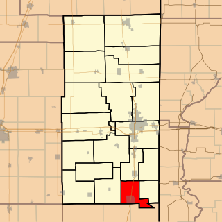
Farm Ridge is an unincorporated community in Farm Ridge Township, LaSalle County, Illinois, United States. Farm Ridge is 4.3 miles (6.9 km) west of Grand Ridge.
The Prairie Ridge State Natural Area is a 4,101-acre (1,660 ha) collaborative natural area managed by the Illinois Department of Natural Resources. It is managed for the benefit of endangered, threatened, watch list, and area sensitive species associated with the tallgrass prairie habitat of south-central Illinois, especially the greater prairie chicken. The natural area is split between land parcels in Jasper County and Marion County, in the U.S. state of Illinois.
Jones Ridge is an unincorporated community in Degognia Township, Jackson County, Illinois, United States. The community is located along County Route 9 and the Union Pacific Railroad 9.5 miles (15.3 km) west-northwest of Gorham.