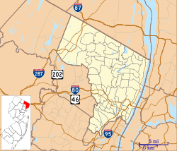
Bergen County is the most populous county in the U.S. state of New Jersey. As of the 2020 United States census, the county's population was 955,732, its highest decennial count ever and an increase of 50,616 (+5.6%) from the 905,116 recorded at the 2010 census, which in turn had reflected an increase of 20,998 (2.4%) from the 884,118 counted at the 2000 census. Located in the northeastern corner of New Jersey and its Gateway Region, Bergen County and its many inner suburbs constitute a highly developed part of the New York City metropolitan area, bordering the Hudson River; the George Washington Bridge, which crosses the Hudson, connects Bergen County with Manhattan.

Route 5 is a 3.18-mile (5.12 km) state highway located entirely in Bergen County, New Jersey, United States. It runs from U.S. Route 1/9 (US 1-9) in Ridgefield east down the New Jersey Palisades to end at County Route 505 at the Hudson River in Edgewater, forming a “wavy” path. The route is a two- to four-lane undivided highway its entire length, passing mostly through wooded residential neighborhoods. The route passes under Route 63 in Palisades Park, with access to that route provided by Bergen Boulevard, and intersects the southern terminus of Route 67 in Fort Lee.

Little Ferry is a borough in Bergen County, in the U.S. state of New Jersey. As of the 2020 United States census, the borough's population was 10,987, an increase of 361 (+3.4%) from the 2010 census count of 10,626, which in turn reflected a decline of 174 (−1.6%) from the 10,800 counted in the 2000 census.
Palisades Park is a borough in Bergen County, in the U.S. state of New Jersey. As of the 2020 United States census, the borough's population was 20,292, an increase of 670 (+3.4%) from the 2010 census count of 19,622, which in turn reflected an increase of 2,549 (+14.9%) from the 17,073 counted in the 2000 census.
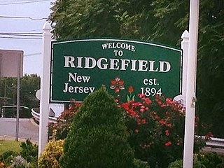
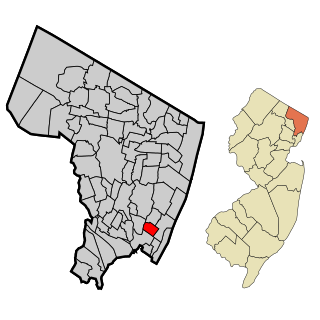
Ridgefield is a borough in Bergen County, in the U.S. state of New Jersey. As of the 2020 United States census, the borough's population was 11,501, an increase of 469 (+4.3%) from the 2010 census count of 11,032, which in turn reflected an increase of 202 (+1.9%) from the 10,830 counted in the 2000 census.

Ridgefield Park is a village in Bergen County, in the U.S. state of New Jersey. As of the 2020 United States census, the village's population was 13,224, an increase of 495 (+3.9%) from the 2010 census count of 12,729, which in turn reflected a decline of 144 (−1.1%) from the 12,873 counted in the 2000 census. Of the 564 municipalities in the state, Ridgefield Park is one of only four with a village type of government, though it operates a Walsh Act form of government. Of the four New Jersey villages, Loch Arbour also uses the commission form of government, while Ridgewood operates under the council-manager form, and the Township of South Orange Village operates under a special charter form with many characteristics of village government.

Route 93 is a state highway in the U.S. state of New Jersey. It is a north–south highway that runs 3.50 miles (5.63 km) from an intersection with U.S. Route 1/9 in Ridgefield on Grand Avenue in Ridgefield, Palisades Park, Leonia, and Englewood before ending at an intersection with Van Nostrand Avenue just north of Route 4. The route originated as Route S5 in 1927, running along the Bergen Turnpike until 1929, when it was moved onto the southern portion of Grand Avenue. It remained the same until 1954, after the alignment of Route 93 had been designated that the route was extended along Grand Avenue.

Interstate 95 (I-95) is a major Interstate Highway that runs along the East Coast of the United States from Miami, Florida, north to the Canadian border in Houlton, Maine. In New Jersey, it runs along much of the mainline of the New Jersey Turnpike, as well as the Pearl Harbor Memorial Turnpike Extension, and the New Jersey Turnpike's I-95 Extension to the George Washington Bridge for a total of 77.96 miles (125.46 km). Located in the northeastern part of the state near New York City, the 11.03-mile (17.75 km) Western Spur of the New Jersey Turnpike, considered to be Route 95W by the New Jersey Department of Transportation (NJDOT), is also part of I-95.
New Jersey's 9th congressional district is represented in Congress by Democrat Bill Pascrell, who resides in Paterson. Congressman Pascrell was first elected in 1996 from the old 8th district, defeating incumbent William J. Martini. The 9th district consists largely of municipalities in Bergen County and Passaic County.
New Jersey's 5th congressional district is represented by Democrat Josh Gottheimer, who has served in Congress since 2017. The district stretches across the entire northern border of the state and contains most of Bergen County, as well as parts of Passaic County and Sussex County.

The Passaic–Bergen–Hudson Transit Project is a project under study by NJ Transit to reintroduce passenger service on a portion of the New York, Susquehanna and Western Railway (NYSW) right-of-way (ROW) in Passaic, Bergen and Hudson counties using newly built, FRA-compliant diesel multiple unit rail cars. Plans call for service to run from Hawthorne south through Paterson, east to Hackensack and then southeast to North Bergen, where it would join the Hudson-Bergen Light Rail (HBLR).
Route 63 is a short, 3.09-mile (4.97 km) long state highway in Hudson and Bergen counties in New Jersey. The route is known as Bergen Boulevard and concurrent with County Route 501 for most of its alignment. The southern terminus is at Kennedy Boulevard and County Route 501 in North Bergen. The route crosses the county line and heads along the boulevard through the communities of Ridgefield, Palisades Park, and Fort Lee before reaching its northern terminus at an interchange with U.S. Route 1-9 and 46 in Fort Lee.

Dutch Reformed Church in the English Neighborhood is a historic church at 1040 Edgewater Avenue in Ridgefield, Bergen County, New Jersey, United States. The church was built in 1793 and added to the National Register of Historic Places on September 18, 1998.

New Jersey's 36th Legislative District is one of 40 districts that make up the map for the New Jersey Legislature. It encompasses the Bergen County municipalities of Carlstadt, Cliffside Park, East Rutherford, Little Ferry, Lyndhurst, Moonachie, North Arlington, Ridgefield, Ridgefield Park, Rutherford, South Hackensack, Teterboro, Wallington, and Wood-Ridge and the city of Passaic in Passaic County.

The Edgewater Branch was a branch of the New York, Susquehanna and Western Railway (NYS&W) that ran about 3.174 miles (5.108 km) through eastern Bergen County, New Jersey in the United States. Starting from a rail junction at the Little Ferry Yard, it went east through the Edgewater Tunnel to Undercliff to the Hudson Waterfront.
Grantwood is an unincorporated community straddling the boroughs of Cliffside Park and Ridgefield, just south of Fort Lee, in eastern Bergen County, New Jersey, United States.

Middlesex Downs is an unincorporated community located within Monroe Township in Middlesex County, in the U.S. state of New Jersey. The wholly residential settlement contains small homes along Dey Grove Road and Bergen Mills Road with larger homes in developments towards the south. The township-owned James Monroe Memorial Park is also located in this settlement. Much of the area to the north of Dey Grove Road consists of forest land but at one time this was planned to become a large planned community arranged in a street grid. The small property parcels and paper streets remain on township tax maps today.
Morsemere is a neighborhood in Bergen County, in the U.S. state of New Jersey, largely in the northern part of Ridgefield and straddling the border of Palisades Park south of start of U.S. Route 46.
Passaic Junction is a rail yard owned by New York, Susquehanna and Western Railway along the border of Elmwood Park and Saddle Brook in Bergen County, New Jersey, United States. The yard is also known by its telegraph call 'PC'. In the late 19th century, this area had been known as Coalburg Junction. The yard has a connection to and is the official interchange location with Norfolk Southern. Used as a customer car storage yard but has been surrounded by a few small industries. A team track is also located here.

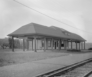
Ridgefield is a proposed station along NJ Transit's (NJT) Northern Branch Corridor Project extension of Hudson-Bergen Light Rail (HBLR) in Ridgefield, New Jersey.