Westmoreland Street, London

Last updated

Westmoreland Street
Westmoreland Street, London W1.jpg
Westmoreland Street looking south
Former name(s)Woodstock Street (north part)
AreaMarylebone
LocationCity of Westminster
Postal codeW1G
Coordinates 51°31′11″N00°09′00″W / 51.51972°N 0.15000°W / 51.51972; -0.15000
Other
Known for
  • Welbeck Chapel (St James's Church)
  • National Heart Hospital

Westmoreland Street is in the Marylebone district of the City of Westminster in London, England. The street was built from the 1760s by William Franks and runs from Beaumont Street and Weymouth Street in the north to New Cavendish Street in the south. It was formerly the location of the Welbeck Chapel, which became St James's Church. In 1968, it was the site of Britain's first heart transplant when the National Heart Hospital was located there. The hospital is now known as University College Hospital at Westmoreland Street.

Contents

Origins and location

Westmoreland Street is located in the Marylebone district of the City of Westminster, London, and runs from Beaumont Street and Weymouth Street in the north to New Cavendish Street in the south. Woodstock Mews is accessed from its eastern side, and Wheatley Street and De Walden Street join it on its western side. It was built from the 1760s by the local builder William Franks. [1] The origin of its name is unknown. [2]

The northern section above Wheatley Street was originally named Woodstock Street, [1] [3] which is still the name of the adjoining mews, and was a separate and narrower street. It was widened in 1862 and 1874 until the two streets became one. [1]

Another location with the same name, Westmoreland Street, SW1, was renamed to Westmoreland Terrace in the 1930s. [4]

Buildings

Design for St James's Church by George Gilbert Scott Jr., published in The Building News, 1879. St James's Church, Westmoreland Street.jpg
Design for St James's Church by George Gilbert Scott Jr., published in The Building News, 1879.
Historic image of The National Heart Hospital, Westmoreland Street, now University College Hospital. National Heart Hospital, Westmoreland Street, W1. Wellcome S0007606.jpg
Historic image of The National Heart Hospital, Westmoreland Street, now University College Hospital.
Bomb damage map for the Marylebone Street, Wheatley Street, and Westmoreland Street vicinity Marylebone Street, Wheatley Street, Westmoreland Street bomb damage map.jpg
Bomb damage map for the Marylebone Street, Wheatley Street, and Westmoreland Street vicinity

The street was formerly the location of the Tichfield Chapel, [6] which was built by William Franks facing Wheatley Street. In 1773, he sold it to John Sarson who owned the stable-yard in Little Marylebone Street. It became the Welbeck Chapel around 1800 and in 1817 was transferred to the Crown. It was renovated and in 1831 was renamed St James's Church. [1] Thomas Hartwell Horne spent part of his early clerical career there [7] and Hugh Reginald Haweis officiated from 1866, [1] who has been described as the "most prominent exponent of spiritualism among London clergy". [8] The church was highly successful under Haweis and was renovated again in 1870–71 with the installation of new stained-glass windows and later in the decade George Gilbert Scott Jr. drew-up designs for a new exterior. [9] The church stagnated under the later years of Haweis's tenure after he was affected by scandal, and it closed two years after his death in 1901. It was demolished around 1907. [1] Records relating to the church are held by the British National Archives. [10]

It is the former home of the National Heart Hospital, which moved there from Soho Square in 1914, [11] [12] and occupies the site left vacant by the demolition of St James's Church. [1] During the First World War it became a centre for the treatment of military recruits with heart problems. [13] In 1968, Donald Ross and his team carried out Britain's first heart transplant there. [13] [14] That day, on 3 May 1968, traffic stood still while the ambulance arrived with the donor heart, and photographs of the street appeared in the Sun, Daily Mail and Daily Express. [15] The hospital moved to the Fulham Road, London, in 1991 [12] and after a period of private ownership the hospital in 2001 re-entered the National Health Service, [16] where it is known as University College Hospital at Westmoreland Street. [17]

Westmoreland Street and Wheatley Street were seriously damaged by German bombing during the Second World War with the whole of Wheatley Street marked as damaged to some degree. Numbers 18 to 28 on the south side of Wheatley at the Westmoreland end were hit in September 1940 during the Blitz and marked as "damaged beyond repair" on the London County Council's bomb damage maps [18] but were rebuilt in duplicate in 1948. [1] The maps also show blast damage to other buildings on the west side of Westmoreland Street and to a row of six buildings on the east side of the street opposite the entrance to Wheatley Street, including the hospital. [1] [18] The King's Head public house at 13 Westmoreland Street, on the corner with Wheatley Street, was badly damaged and required partial rebuilding. [1]

Related Research Articles

<span class="mw-page-title-main">City of Westminster</span> City and borough in London, England

The City of Westminster is a city and borough in London. It is the site of the United Kingdom's Houses of Parliament and much of the British government. It occupies a large area of central London, including most of the West End. Many London landmarks are within the borough, including Buckingham Palace, Westminster Abbey, Whitehall, Westminster Cathedral, 10 Downing Street, and Trafalgar Square.

<span class="mw-page-title-main">William Cavendish-Bentinck, 3rd Duke of Portland</span> British politician and prime minister (1738–1809)

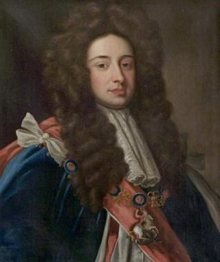
William Henry Cavendish Cavendish-Bentinck, 3rd Duke of Portland, was a British Whig and then a Tory politician during the late Georgian era. He served as Chancellor of the University of Oxford (1792–1809) and as Prime Minister of Great Britain (1783) and then of the United Kingdom (1807–1809). The gap of 26 years between his two terms as Prime Minister is the longest of any British Prime Minister. He was also the fourth great-grandfather of King Charles III through his great-granddaughter Cecilia Bowes-Lyon, Countess of Strathmore and Kinghorne.

<span class="mw-page-title-main">Fitzrovia</span> Human settlement in England

Fitzrovia is a district of central London, England, near the West End. The eastern part of area is in the London Borough of Camden, and the western in the City of Westminster. It has its roots in the Manor of Tottenham Court, and was urbanised in the 18th century. Its name was coined in the late 1930s by Tom Driberg.

<span class="mw-page-title-main">Metropolitan Borough of St Marylebone</span> Metropolitan borough of England

The Metropolitan Borough of St Marylebone was a metropolitan borough of the County of London from 1900 to 1965. It was based directly on the previously existing civil parish of St Marylebone, Middlesex, which was incorporated into the Metropolitan Board of Works area in 1855, retaining a parish vestry, and then became part of the County of London in 1889.
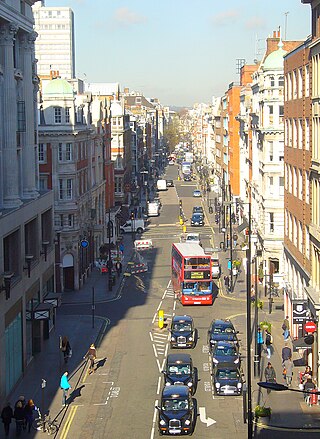
<span class="mw-page-title-main">Great Portland Street</span>

Great Portland Street in Marylebone, in the West End of London, links Oxford Street with the A501 Marylebone Road. The street, which is part of a broader rectilinear street pattern, includes the Embassy of the Democratic Republic of the Congo. and a number of small independent shops.

<span class="mw-page-title-main">John Holles, 1st Duke of Newcastle</span> British peer

John Holles, 1st Duke of Newcastle, KG, PC was an English peer.

<span class="mw-page-title-main">St Marylebone (UK Parliament constituency)</span> Parliamentary constituency in the United Kingdom, 1918-1983

St Marylebone was a parliamentary constituency centred on the Marylebone district of Central London. It returned one Member of Parliament (MP) to the House of Commons of the Parliament of the United Kingdom.

<span class="mw-page-title-main">Welbeck Street</span> Street in the West End, central London

Welbeck Street is a street in the West End, central London. It has historically been associated with the medical profession. Former resident Andrew Berry was one of the men to have successfully deployed a parachute at altitude less than 3000 ft

<span class="mw-page-title-main">Selina Hastings, Countess of Huntingdon</span> British countess

Selina Hastings, Countess of Huntingdon was an English religious leader who played a prominent part in the religious revival of the 18th century and the Methodist movement in England and Wales. She founded an evangelical branch in England and Sierra Leone, known as the Countess of Huntingdon's Connexion.

<span class="mw-page-title-main">St Marylebone Parish Church</span> Church in London , United Kingdom

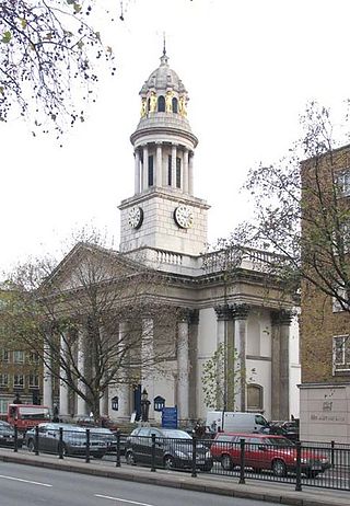
St Marylebone Parish Church is an Anglican church on the Marylebone Road in London. It was built to the designs of Thomas Hardwick in 1813–17. The present site is the third used by the parish for its church. The first was further south, near Oxford Street. The church there was demolished in 1400 and a new one erected further north. This was completely rebuilt in 1740–42, and converted into a chapel-of-ease when Hardwick's church was constructed. The Marylebone area takes its name from the church. Located behind the church is St Marylebone School, a Church of England school for girls.

<span class="mw-page-title-main">St Peter, Vere Street</span> Church in London, England

St Peter, Vere Street, known until 1832 as the Oxford Chapel after its founder Edward Harley, 2nd Earl of Oxford and Earl Mortimer, is a former Anglican church off Oxford Street, London. It has sometimes been referred to as the Marybone Chapel or Marylebone Chapel.

<span class="mw-page-title-main">Henrietta Harley, Countess of Oxford and Countess Mortimer</span> English noblewoman

Henrietta Harley, Countess of Oxford and Countess Mortimer was an English noblewoman, the only child and heiress of John Holles, 1st Duke of Newcastle and his wife, the former Lady Margaret Cavendish, daughter of Henry Cavendish, 2nd Duke of Newcastle-upon-Tyne.

<span class="mw-page-title-main">Marylebone</span> Area in London, England

Marylebone is a district in the West End of London, in the City of Westminster. Oxford Street forms its southern boundary.

<span class="mw-page-title-main">Bolsover Street</span> Street in City of Westminster, United Kingdom

Bolsover Street is in the Parish of St Marylebone in London's West End. In administrative terms it lies within the City of Westminster's Marylebone High Street Ward and is partly in the Harley Street Conservation Area whilst also sitting on the edges of the Regents Park and East Marylebone Conservation Areas.

<span class="mw-page-title-main">St Winifred's Church, Holbeck</span> Church in Nottinghamshire, England

St Winifred's Chapel, Holbeck is a Grade II listed parish church and former private chapel in the Church of England in Holbeck, Nottinghamshire, south-west of Worksop. Holbeck is an estate village built for the Dukes of Portland at Welbeck Abbey.

<span class="mw-page-title-main">St John's Wood Church</span> Church in London , United Kingdom

St John's Wood Church is a Church of England parish church in St John's Wood, London. The church is located on Lord's Roundabout, between Lord's Cricket Ground and Regent's Park, and has a Grade II* listing. The parish is in the Archdeaconry of Charing Cross, in the deanery of Westminster St Marylebone.

<span class="mw-page-title-main">Weymouth Street</span> Street in the City of Westminster, London, England

Weymouth Street lies in the Marylebone district of the City of Westminster and connects Marylebone High Street with Great Portland Street. The area was developed in the late 18th century by Henrietta Cavendish Holles and her husband Edward Harley, 2nd Earl of Oxford. This part of Marylebone originally belonged to the Manor of Tyburn which existed at the time of the Domesday Book (1086).

<span class="mw-page-title-main">Greenwell Street</span> Street in the City of Westminster, London

Greenwell Street, formerly Buckingham Street, is located in the Fitzrovia district of the City of Westminster in London. It was built in the late eighteenth century and runs between Bolsover Street in the east and Cleveland Street in the west. Great Titchfield Street joins it on its south side. On the south side is the grade II listed George and Dragon public house (c.1850) and the site of the home of the sculptor John Flaxman, the location of which is marked by a plaque.

<span class="mw-page-title-main">Henrietta Place</span>

Henrietta Place, originally known as Henrietta Street, is a street in Marylebone in the City of Westminster in central London that runs from Marylebone Lane in the east to Cavendish Square in the west. It is joined on the north side by Welbeck Street and Wimpole Street, and on the south side by Vere Street, Chapel Place, and Old Cavendish Street.

This is a list of the etymology of street names in the London district of Marylebone. The following utilises the generally accepted boundaries of Marylebone viz. Marylebone Road to the north, Great Portland Street to the east, Marble Arch and Oxford Street to the south and Edgware Road to the west.

References

  1. 1 2 3 4 5 6 7 8 9 10 "Chapter 16: Beaumont Street to New Cavendish Street" Archived 31 March 2021 at the Wayback Machine in South-East Marylebone, Survey of London Vols. 51 & 52, London, 2017.
  2. "Westmoreland Street" in Gillian Bebbington (1972) London Street Names. London: B.T. Batsford. p. 343. ISBN 0713401400.
  3. Laxton, Paul & Joseph Wisdom. (1985) The A to Z of Regency London. London: London Topographical Society. p. 24. ISBN 0902087193
  4. https://www.maps.thehunthouse.com/Streets/Old_to_New_London_Street_Name_Changes.htm
  5. The Building News, 17 October 1879.
  6. Smith, Thomas. (1833) A Topographical and Historical Account of the Parish of St. Mary-le-Bone &c. Archived 7 March 2022 at the Wayback Machine London: John Smith. p. 125.
  7. "The Late Rev. T. Hartwell Horne", The Illustrated London News , Vol. 40, No. 1132 (22 February 1862), p. 190.
  8. Jacob, W. M. (2021). Religious Vitality in Victorian London. Oxford: Oxford University Press. p. 187. ISBN   978-0-19-289740-4. Archived from the original on 17 March 2022. Retrieved 11 March 2022.
  9. 1879 – St James's Church, Marylebone, London Archived 7 March 2022 at the Wayback Machine archiseek. Retrieved 8 March 2022.
  10. St. James' Chapel. (Welbeck Chapel) Westmoreland Street. Archived 7 March 2022 at the Wayback Machine National Archives. Retrieved 8 March 2022.
  11. "Nova et Vetera" . British Medical Journal. 1 (5034): 1528. 29 June 1957. doi:10.1136/bmj.1.5034.1528-a. ISSN   0007-1447. S2CID   220146496. Archived from the original on 10 March 2022. Retrieved 10 March 2022.
  12. 1 2 "National Heart Hospital" Archived 7 March 2022 at the Wayback Machine in Christopher Hibbert; Ben Weinreb; John Keay; Julia Keay. (2008). The London Encyclopaedia (3rd ed.). London: Macmillan. p. 570. ISBN   978-0-230-73878-2.{{cite book}}: CS1 maint: multiple names: authors list (link)
  13. 1 2 Nathoo, Ayesha (2009). Hearts Exposed: Transplants and the media in 1960s Britain. Basingstoke: Palgrave Macmillan. p. 9. ISBN   978-1-4039-8730-3. Archived from the original on 17 March 2022. Retrieved 8 March 2022.
  14. "Man of 45 gets new heart in first British transplant", The Times, 4 May 1968, p. 1.
  15. Nathoo, A. (2009). Hearts Exposed: Transplants and the Media in 1960s Britain. Basingstoke: Palgrave Macmillan. pp. 112–114. ISBN   978-0-230-23470-3. Archived from the original on 17 March 2022. Retrieved 11 March 2022.
  16. NHS buys private heart hospital. Archived 17 January 2008 at the Wayback Machine BBC News, 8 August 2001. Retrieved 10 March 2022.
  17. University College Hospital at Westmoreland Street (formerly the Heart Hospital). Archived 9 October 2015 at the Wayback Machine University College London Hospitals. Retrieved 17 September 2015.
  18. 1 2 Ward, Laurence. (2015) The London County Council Bomb Damage Maps 1939–1945. London: Thames & Hudson. p. 92. ISBN 9780500518250

Commons-logo.svg Media related to Westmoreland Street, London at Wikimedia Commons