
Yavapai County is a county near the center of the U.S. state of Arizona. As of the 2020 census, its population was 236,209, making it the fourth-most populous county in Arizona. The county seat is Prescott.

Lake Montezuma is a census-designated place (CDP) in Yavapai County in the U.S. state of Arizona. The population was 5,111 at the 2020 census. The CDP includes the communities of Rimrock and McGuireville. Located along Interstate 17, it is 20 miles (32 km) south of Sedona and 8 miles (13 km) north of Camp Verde in central Arizona's Verde Valley.

The Salt River is a river in Gila and Maricopa counties in Arizona, United States, that is the largest tributary of the Gila River. The river is about 200 miles (320 km) long. Its drainage basin covers about 13,700 square miles (35,000 km2). The longest of the Salt River's many tributaries is the 195-mile (314 km) Verde River. The Salt's headwaters tributaries, the Black River and East Fork, increase the river's total length to about 300 miles (480 km). The name Salt River comes from the river's course over large salt deposits shortly after the merging of the White and Black Rivers.

The Apache–Sitgreaves National Forests is a 2.76-million-acre (11,169 km2) United States National Forest which runs along the Mogollon Rim and the White Mountains in east-central Arizona and into the U.S. state of New Mexico. Formerly two forests, it is currently managed as one unit by USDA Forest Service from the Forest Supervisors Office in Springerville, Arizona. Apache–Sitgreaves has over 400 species of wildlife. With its high elevation and cool summer breezes it is a popular weekend destination from the hot desert for Phoenix, Arizona, residents. The forest is divided into 5 Ranger Districts that span almost 300 miles (480 km) from Clifton, Arizona in the east-central portion of Arizona to the eastern boundary of the Coconino National Forest in north-central Arizona. The Apache–Sitgreaves National Forest borders the western and northern borders of the Fort Apache Indian Reservation. It is located in parts of Greenlee, Apache, Navajo, and Coconino counties in eastern and east-central Arizona, and Catron County in western New Mexico. The more northwesterly Sitgreaves National Forest portion lies adjacent to the north side of the Fort Apache Indian Reservation and is located entirely in Arizona, within Navajo, Apache, and Coconino counties. It has a total area of 818,651 acres (3,313 km2). The more southeasterly and much larger Apache National Forest portion lies adjacent to the east side of the Fort Apache and the San Carlos Indian Reservations. It lies on both sides of the border with New Mexico, in Greenlee, Catron, and Apache counties. It has a total area of 1,813,601 acres (7,339 km2).

The Verde River is a major tributary of the Salt River in the U.S. state of Arizona. It is about 170 miles (270 km) long and carries a mean flow of 602 cubic feet per second (17.0 m3/s) at its mouth. It is one of the largest perennial streams in Arizona.

The Monongahela National Forest is a national forest located in the Allegheny Mountains of eastern West Virginia, US. It protects over 921,000 acres of federally managed land within a 1,700,000 acres proclamation boundary that includes much of the Potomac Highlands Region and portions of 10 counties.
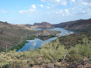
Canyon Lake is one of four reservoirs that were formed by the damming of the Salt River in the U.S. state of Arizona as part of the Salt River Project. It was formed by the Mormon Flat Dam, which was completed in 1925 after two years of construction. Canyon Lake, with a surface area of 950 acres (380 ha), is the third and smallest of the four lakes created along the river. Two others, Apache Lake and Roosevelt Lake, are upstream. The fourth, Saguaro Lake, is downstream.

The Flathead National Forest is a national forest in the western part of the U.S. state of Montana. The forest lies primarily in Flathead County, south of Glacier National Park. The forest covers 2,404,935 acres of which about 1 million acres (4,000 km2) is designated wilderness. It is named after the Flathead Native Americans who live in the area.

The Coconino National Forest is a 1.856-million acre United States National Forest located in northern Arizona in the vicinity of Flagstaff, with elevations ranging from 2,600 feet to the highest point in Arizona at 12,633 feet. Originally established in 1898 as the "San Francisco Mountains National Forest Reserve", the area was designated a U.S. National Forest by Pres. Theodore Roosevelt on July 2, 1908, when the San Francisco Mountains National Forest Reserve was merged with lands from other surrounding forest reserves to create the Coconino National Forest. Today, the Coconino National Forest contains diverse landscapes, including deserts, ponderosa pine forests, flatlands, mesas, alpine tundra, and ancient volcanic peaks.

The Prescott National Forest is a 1.25 million-acre United States National Forest located in north central Arizona in the vicinity of Prescott. The forest is located in the mountains southwest of Flagstaff and north of Phoenix in Yavapai County, with a small portion extending into southwestern Coconino County.

The Chattahoochee–Oconee National Forest in northern Georgia comprises two United States National Forests, the Oconee National Forest in eastern Georgia and the Chattahoochee National Forest located in the North Georgia Mountains. The Chattahoochee National Forest is composed of an eastern and western forest. The western forest contains Johns Mountain, Little Sand Mountain, and Taylor Ridge (Georgia). The combined total area of the Chattahoochee–Oconee National Forest is 867,265 acres (3,510 km2), of which the Chattahoochee National Forest comprises 751,069 acres (3,039 km2) and the Oconee National Forest comprises 116,196 acres (470 km2). The county with the largest portion of the eastern forest is Rabun County, Georgia, which has 148,684 acres (601.7 km2) within its boundaries.

The Gila National Forest is a United States national forest in New Mexico. Established in 1905, it now covers approximately 2,710,659 acres (10,969.65 km2), making it the sixth largest national forest in the continental United States. The Forest administration also manage the part of the Apache National Forest in New Mexico which covers 614,202 acres for a total of 3.3 million acres managed by the Gila National Forest. Within the forest, the Gila Wilderness was established in 1924 as the US's first designated wilderness. The Aldo Leopold Wilderness and Blue Range Wilderness are also found within its borders. The Blue Range Primitive Area lies within Arizona in the neighboring Apache National Forest.

Oak Creek Canyon is a river gorge located in northern Arizona between the cities of Flagstaff and Sedona. The canyon is often described as a smaller cousin of the Grand Canyon because of its scenic beauty. State Route 89A enters the canyon on its north end via a series of hairpin turns before traversing the bottom of the canyon for about 13 miles (21 km) until the highway enters the town of Sedona.
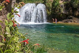
Fossil Creek is a perennial stream accessed by forest roads near the community of Camp Verde in the U.S. state of Arizona. Primary access is from Forest Road 708 off Arizona State Route 260 east of Camp Verde. A tributary of the Verde River, Fossil Creek flows from its headwaters on the Mogollon Rim to meet the larger stream near the former Childs Power Plant.

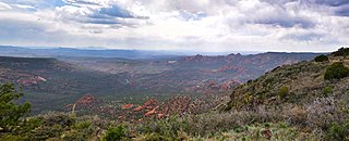
Sycamore Canyon is the second largest canyon in the Arizona redrock country, after Oak Creek Canyon. The 21-mile (34 km) long scenic canyon reaches a maximum width of about 7 miles (11 km). It is in North Central Arizona bordering and below the Mogollon Rim, and is located west and northwest of Sedona in Yavapai and Coconino counties.
Sycamore Canyon Wilderness is a 56,000-acre wilderness area in the Coconino, Kaibab and Prescott national forests in the U.S. state of Arizona. Encompassing Sycamore Canyon and its surrounds from south of Williams to the confluence of Sycamore Creek with the Verde River, the wilderness is about 40 miles (64 km) southwest of Flagstaff. The canyon is one of several in Arizona that cut through the Mogollon Rim. Relevant United States Geological Survey (USGS) map quadrangles are Davenport Hill, White Horse Lake, May Tank Pocket, Perkinsville, Sycamore Basin, and Clarkdale. Red Rock-Secret Mountain Wilderness borders Sycamore Canyon Wilderness on the east.
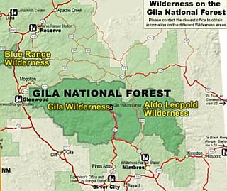
Gila Wilderness was designated the world's first wilderness area on June 3, 1924. Along with Aldo Leopold Wilderness and Blue Range Wilderness, the 558,014 acre wilderness is part of New Mexico's Gila National Forest. The wilderness is approximately 27 miles (43 km) from north to south and 39 miles (63 km) east to west.

The San Mateo Mountains are a mountain range in Socorro County, in west-central New Mexico in the southwestern United States. The highest point in the range is West Blue Mountain, at 10,336 ft. The range runs roughly north–south and is about 40 miles (64 km) long. It lies about 25 miles (40 km) north-northwest of the town of Truth or Consequences and about 30 miles (48 km) southwest of Socorro. They should not be confused with the identically named range in Cibola and McKinley counties, north of this range.

The Red Rock-Secret Mountain Wilderness is a 47,195-acre wilderness area located within the Coconino National Forest in the U.S. state of Arizona.

Haigler Creek is an unincorporated community and census-designated place (CDP) in northern Gila County, Arizona, United States. It lies at an elevation of 5,240 feet and is surrounded by the Tonto National Forest. As of the 2020 census, Haigler Creek had a population of 39 people.


