Montezuma Well

Last updated • 4 min readFrom Wikipedia, The Free Encyclopedia

34°38′57″N111°45′08″W / 34.64917°N 111.75222°W / 34.64917; -111.75222

Contents

Montezuma Well in 2016 Montezuma Well crop.jpg
Montezuma Well in 2016
Montezuma Well irrigation ditch, used since antiquity, but rebuilt many times. 2021 Montezuma Well, irrigation ditch 1.jpg
Montezuma Well irrigation ditch, used since antiquity, but rebuilt many times.
The pithouse ruin; the two largest holes in the dirt floor held the timber which supported the roof. The holes around the edge reveal the outline of the structure. Camp Verde- Montezuma Well-Sinagua pit house ruins-1.jpg
The pithouse ruin; the two largest holes in the dirt floor held the timber which supported the roof. The holes around the edge reveal the outline of the structure.

Montezuma Well (Yavapai : ʼHakthkyayva), a detached unit of Montezuma Castle National Monument, [1] is a natural limestone sinkhole near the town of Lake Montezuma, Arizona, through which some 1,500,000 US gallons (5,700,000 L; 1,200,000 imp gal) of water emerge each day from an underground spring. It is located about 11 miles (18 km) northeast of Montezuma Castle.

The "well" measures 386 feet (118 m) in diameter from rim to rim and contains a near-constant volume of spring water even in times of severe drought. The water is highly carbonated and contains high levels of arsenic. At least five endemic species, the most of any spring in the southwestern United States, are found exclusively in Montezuma Well: a diatom, the Montezuma Well springsnail, a water scorpion, the Hyalella montezuma amphipod, and the Motobdella montezuma leech.

Montezuma Well's steady outflow has been used for irrigation since the 8th century. Part of a prehistoric irrigation ditch is preserved near the park's picnic ground, and portions of the ditch's original route are still in use today.

As with Montezuma Castle, the label "Montezuma" is a misnomer: the Aztec emperor Montezuma had no connection to the site or the early indigenous peoples that occupied the area.

Geology

Montezuma Well is geologically very similar to the sinkholes and cenotes found in Florida and the Yucatán peninsula of Mexico, that is, a limestone cave which has collapsed to expose its subterranean water source. The Well sits at the northern end of the Verde Limestone formation, a distinct layer of travertine limestone more than 2,000 feet (610 m) thick in some places, which was deposited beneath a series of shallow lakes that covered Arizona's central Verde Valley region between 8 and 2 million years ago.

History

Archaeological evidence suggests that humans have lived in the Verde Valley for at least 10,000 years. The earliest signs of permanent settlement in the area appear quite a bit later, however, around 600 CE.

The ruins of several prehistoric dwellings are scattered in and around the rim of the Well. Their inhabitants belonged to several indigenous American cultures that are believed to have occupied the Verde Valley between 700 and 1425 CE, the foremost of which being a cultural group archaeologists have termed the Southern Sinagua. [2] The earliest of the ruins located on the property (with the exception of the irrigation canal), a "pithouse" in the traditional Hohokam style, dates to about 1050 CE. More than 50 countable "rooms" are found inside the park boundaries; it is likely that some were used for purposes other than living space, including food storage and religious ceremonies.

The Sinagua people, and possibly earlier cultures, intensively farmed the land surrounding the Well using its constant outflow as a reliable source of irrigation. Beginning about 700 CE, the Well's natural drainage into the immediately adjacent Wet Beaver Creek was diverted into a man-made canal running parallel to the creek, segments of which still conduct the outflow today. The prehistoric canal, estimated at nearly seven miles in length, likely drained into a network of smaller lateral canals downstream, supplying perhaps as much as 60 acres of farmland with water. [2] The route of the modern canal is partly original, especially close to the outlet, but large portions have been re-routed over time as irrigation needs have changed. Much of the abandoned original route is still visible within the park, however, as the warm water emerging from the Well contains a high concentration of lime, which over many centuries was deposited along the canal walls as the water cooled downstream; the accumulated lime has since hardened into a cement-like coating, preserving the canal's shape.

The existence of the Well was almost unknown to European Americans before the publishing of Handbook to Arizona by Richard J. Hinton in 1878. In 1968, Montezuma Well was the subject of the first ever underwater archaeological survey to take place in a federally managed park, led by archaeologist George R Fischer.

The Yavapai people consider the Well a deeply sacred site, as they believe it is the place through which they emerged into the world. [3]

Ecology

The high concentration of dissolved carbon dioxide gas in the water of the Well which amounts to more than 80 times the typical freshwater concentration and to a lesser extent its alkalinity, has prevented the development of any kind of fish population, so the Well remains a fishless spring. However, other types of aquatic life have managed to adapt: at least five endemic species, the most of any spring in the southwestern United States, are found exclusively in Montezuma Well: a diatom Gomphonema montezumense [4] , the Montezuma Well springsnail, a water scorpion, the amphipod known as Hyalella montezuma , and the leech species Motobdella montezuma . [5] Many different bird species feed on these organisms and the plant life found in the water.

In recent years Illinois pondweed (Potamogeton illinoensis) has invaded the Well. Weekly maintenance is required to keep water from the Well flowing through the natural outlet and into the irrigation ditch. [1]

See also

Related Research Articles

<span class="mw-page-title-main">Cornville, Arizona</span> CDP in Yavapai County, Arizona

Cornville is a unincorporated community in Yavapai County, Arizona, United States. The population as of the 2010 United States Census was 3,280, down from 3,335 at the 2000 census. For statistical purposes, the United States Census Bureau has defined Cornville as a census-designated place (CDP) that includes the communities of Cornville and Page Springs.

<span class="mw-page-title-main">Lake Montezuma, Arizona</span> CDP in Yavapai County, Arizona

Lake Montezuma is a census-designated place (CDP) in Yavapai County in the U.S. state of Arizona. The population was 5,111 at the 2020 census. The CDP includes the communities of Rimrock and McGuireville. Located along Interstate 17, it is 20 miles (32 km) south of Sedona and 8 miles (13 km) north of Camp Verde in central Arizona's Verde Valley.

<span class="mw-page-title-main">Verde Valley</span> Valley in central Arizona, US

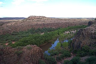
The Verde Valley is a valley in central Arizona in the United States. The Verde River runs through it. The Verde River is one of Arizona's last free-flowing river systems. It provides crucial habitat for fish and wildlife, fresh water for local agricultural production, recreational opportunities for locals and tourists alike, and brings clean drinking water to over 2 million people in the greater Phoenix area. The valley is overlooked by Mingus Mountain and the Mogollon Rim. The valley is one of three regions of viticulture in Arizona and contains the Verde Valley AVA.

<span class="mw-page-title-main">Montezuma Castle National Monument</span> Ancient dwellings in Yavapai County, Arizona, US

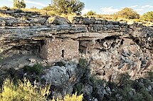
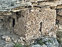
Montezuma Castle National Monument protects a set of well-preserved dwellings located in Camp Verde, Arizona, which were built and used by the Sinagua people, a pre-Columbian culture closely related to the Hohokam and other indigenous peoples of the southwestern United States, between approximately AD 1100 and 1425. The main structure comprises five stories and about 20 rooms and was built over the course of three centuries.

<span class="mw-page-title-main">Cliff Palace</span> Human settlement in Montezuma County, Colorado, United States of America

Cliff Palace is the largest cliff dwelling in North America. The structure built by the Ancestral Puebloans is located in Mesa Verde National Park in their former homeland region. The cliff dwelling and park are in Montezuma County, in the southwestern corner of Colorado, in the Southwestern United States.

Indigenous peoples of Arizona are the Native American people who currently live or have historically lived in what is now the state of Arizona. There are 22 federally recognized tribes in Arizona, including 17 with reservations that lie entirely within its borders. Reservations make up over a quarter of the state's land area. Arizona has the third largest Native American population of any U.S. state.

<span class="mw-page-title-main">Walnut Canyon National Monument</span> Protected area in Coconino County, Arizona

Walnut Canyon National Monument is a United States National Monument located about 10 mi (16 km) southeast of downtown Flagstaff, Arizona, near Interstate 40. The canyon rim elevation is 6,690 ft (2,040 m); the canyon's floor is 350 ft (110 m) lower. A 0.9 mi (1.4 km) long loop trail descends 185 ft (56 m) into the canyon passing 25 cliff dwelling rooms constructed by the Sinagua, a pre-Columbian cultural group that lived in Walnut Canyon from about 1100 to 1250 AD. Other contemporary habitations of the Sinagua people are preserved in the nearby Tuzigoot and Montezuma Castle national monuments.

<span class="mw-page-title-main">Sinagua</span> Pre-Columbian culture in Arizona, US

The Sinagua were a pre-Columbian culture that occupied a large area in central Arizona from the Little Colorado River, near Flagstaff, to the Verde River, near Sedona, including the Verde Valley, area around San Francisco Mountain, and significant portions of the Mogollon Rim country, between approximately 500 and 1425 CE.

<span class="mw-page-title-main">Fossil Creek</span> Perennial stream in Arizona, US

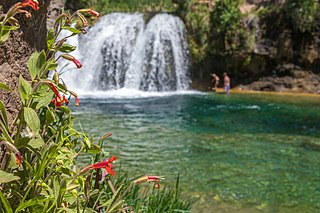
Fossil Creek is a perennial stream accessed by forest roads near the community of Camp Verde in the U.S. state of Arizona. Primary access is from Forest Road 708 off Arizona State Route 260 east of Camp Verde. A tributary of the Verde River, Fossil Creek flows from its headwaters on the Mogollon Rim to meet the larger stream near the former Childs Power Plant.

<span class="mw-page-title-main">Yavapai</span> Indigenous people from Arizona

The Yavapai are a Native American tribe in Arizona. Their Yavapai language belongs to the Upland Yuman branch of the proposed Hokan language family.

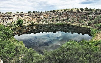
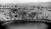
The Montezuma Well springsnail is a species of freshwater snail in the family Hydrobiidae, the mud snails. It is endemic to Montezuma Well, a large sinkhole in Yavapai County, Arizona, in the United States.

The Page springsnail is a species of freshwater snail in the family Hydrobiidae, the mud snails. It is endemic to Arizona in the United States, where it is known only from the Upper Verde River drainage in Yavapai County.

Motobdella montezuma is a species of leech which is only found in Montezuma Well, central Arizona, United States. It is a nocturnal pelagic predator that feeds almost exclusively on the endemic amphipod Hyalella montezuma, which it detects using passive sonar and swallows whole.

<span class="mw-page-title-main">Tonto Basin</span> Landform in Gila County, Arizona

The Tonto Basin, also known as Pleasant Valley, covers the main drainage basin of Tonto Creek and its tributaries in central Arizona, at the southwest of the Mogollon Rim, the higher elevation transition zone across central and eastern Arizona. Although the word tonto means silly or foolish in Spanish, this place name is derived from the Apache word, Koun’nde, which means wild, rough people and refers to the indigenous Dilzhe’e Tonto Apache.

<i>Hyalella azteca</i> Species of crustacean

Hyalella azteca is a widespread and abundant species complex of amphipod crustacean in North America. It reaches 3–8 mm (0.12–0.31 in) long, and is found in a range of fresh and brackish waters. It feeds on algae and diatoms and is a major food of waterfowl.

<span class="mw-page-title-main">Honanki</span> Cliff dwelling in Yavapai County, Arizona

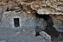
The Honanki Heritage Site is a cliff dwelling and rock art site located in the Coconino National Forest, about 15 miles (24 km) west of Sedona, Arizona. The Sinagua people of the Ancestral Puebloans, and ancestors of the Hopi people, lived here from about 1100 to 1300 CE. The Palatki Heritage Site is nearby, also in the Coconino National Forest.

<span class="mw-page-title-main">Tuzigoot National Monument</span> Historic site in Yavapai County, Arizona, US

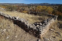
Tuzigoot National Monument preserves a 2- to 3-story pueblo ruin on the summit of a limestone and sandstone ridge just east of Clarkdale, Arizona, 120 feet (37 m) above the Verde River floodplain. The Tuzigoot Site is an elongated complex of stone masonry rooms that were built along the spine of a natural outcrop in the Verde Valley. The central rooms stand higher than the others and they appear to have served public functions. The pueblo has 110 rooms. The National Park Service currently administers 58 acres, within an authorized boundary of 834 acres.

<span class="mw-page-title-main">History of Flagstaff, Arizona</span>

Flagstaff is a city in, and the county seat of, Coconino County in northern Arizona, in the southwestern United States. Established as a modern settlement in 1876 and incorporated as a city in 1928, the land had previously been lived on by native peoples of the southwest, primarily the Sinagua. Mountaineer Antoine Leroux then traveled the area, with Edward Fitzgerald Beale following in his footsteps and establishing a trail through the city in the mid-1800s. With a local spring, a small settlement grew by the wagon road, and the town was dominated by the McMillan, Riordan, and Babbitt families. Focused on agricultural pursuits, these families constructed some historic red stone buildings that still stand today.

References

  1. 1 2 "Montezuma Well". National Park Service.
  2. 1 2 Beckman, Jack. "A History of Montezuma Well". 1990.
  3. "ITCA: Fort McDowell Yavapai Nation". Archived from the original on 2003-08-19.
  4. "Gomphonema montezumense. In Diatoms of North America".
  5. 2007, Larry Stevens, Plateau magazine, v. 4 no. 1, Museum of Northern Arizona. ISBN   0-89734-135-X