Wet Mountain Valley

Last updated
Wet Mountain Valley in a mist Morning Mist wet mtn.jpg
Wet Mountain Valley in a mist
The Beckwith Ranch with the Sangre de Cristos in the background. Beckwith Ranch.JPG
The Beckwith Ranch with the Sangre de Cristos in the background.

The Wet Mountain Valley [1] is a high elevation mountain valley mostly located in Custer County but extending southward into Huerfano County in south-central Colorado. Westcliffe and Silver Cliff are the two towns in the valley which is mostly devoted to cattle ranching.

Contents

Geography

The Wet Mountain Valley is nestled beneath the Wet Mountains on the east, and the Sangre de Cristo Range that parallels the valley on the west. Both mountain ranges are in the Sangre de Cristo Mountains system of the Southern Rocky Mountains. The valley is approximately 30 mi (48 km) long from north to south and 12 mi (19 km) wide with elevations of between 7,500 ft (2,300 m) and 9,000 ft (2,700 m). [2]

The two towns in the valley are Westcliffe and Silver Cliff which are located side by side at an elevation of just under 8,000 feet (2,400 m). According to the U.S. census for 2020, Westcliffe has a population of 435 and Silver Cliff has a population of 609. [3] DeWeese Reservoir is near the two towns. The valley is known for its historic ranches. Conservation easements preserve some of the ranches from sub-division and development. [4] Silver mining attracted early settlers. The sparse remains of two former mining towns, Rosita and Querida, are 7 mi (11 km) east of Westcliffe. Both had a population of more than 1,000 people in 1880. [5] [6]

The valley is drained by two major creeks, both of which rise in the Sangre de Cristos. Grape Creek begins in the south of Custer County near Music Pass and flows north into DeWeese Reservoir; from there it enters a narrow gorge before reaching the Arkansas River. Texas Creek begins northwest of Westcliffe and flows to the northeast meeting the Arkansas River at US Highway 50. A small part of the valley drains southward into the Huerfano River. [7]

In 2015, Westcliff and Silver Cliff became an International Dark Sky Community, the first in Colorado, the ninth in the world, and at the highest elevation of all dark sky communities. The designation as a dark sky community requires a local effort to limit light pollution. An observatory in Westcliffe welcomes tourists. [8]

Climate

The Wet Mountain Valley has a Dfb climate (humid continental with warm summers and cold winters) in the Koppen Classification system and DCblo (humid continental with mild summers and cold winters) in the Trewartha climate classification system. At Westcliffe from 1948 to 2005, the warmest month was July with an average temperature of 62.9 °F (17.2 °C) and the coldest month was January with an average temperature is 23.3 °F (−4.8 °C). Precipitation was 14.44 in (367 mm) annually with the majority in the summer. Snowfall averaged 90.4 in (2,300 mm) annually. The highest elevations of the valley may have a Dfc (continental subarctic) climate. The surrounding mountains have an ET (arctic tundra) climate at elevations above about 11,500 ft (3,500 m) in elevation. [9]

Related Research Articles

<span class="mw-page-title-main">San Luis Valley</span> High-altitude basin in Colorado and New Mexico in the United States

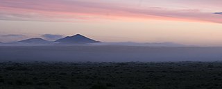
The San Luis Valley is a region in south-central Colorado with a small portion overlapping into New Mexico. The valley is approximately 122 miles (196 km) long and 74 miles (119 km) wide, extending from the Continental Divide on the northwest rim into New Mexico on the south. It contains 6 counties and portions of 3 others. It is an extensive high-altitude depositional basin of approximately 8,000 square miles (21,000 km2) with an average elevation of 7,664 feet (2,336 m) above sea level. The valley is a section of the Rio Grande Rift and is drained to the south by the Rio Grande, which rises in the San Juan Mountains to the west of the valley and flows south into New Mexico. The San Luis Valley has a cold desert climate but has substantial water resources from the Rio Grande and groundwater.

<span class="mw-page-title-main">Huerfano County, Colorado</span> County in Colorado, United States

Huerfano County is a county located in the U.S. state of Colorado. As of the 2020 census, the population was 6,820. The county seat is Walsenburg. The county, whose name comes from the Spanish huérfano meaning "orphan", was named for the Huerfano Butte, a local landmark. The area of Huerfano County boomed early in the 1900s with the discovery of large coal deposits. After large scale World War II coal demand ended in the 1940s Walsenburg and Huerfano saw a steady economic decline through 2015.

<span class="mw-page-title-main">Custer County, Colorado</span> County in Colorado, United States

Custer County is a county located in the U.S. state of Colorado. As of the 2020 census, the population was 4,704. The county seat is Westcliffe.

<span class="mw-page-title-main">Silver Cliff, Colorado</span> Town in Custer County, Colorado, United States

The Town of Silver Cliff is the Statutory Town that is the most populous municipality in Custer County, Colorado, United States. The population was 587 at the 2010 census, up from 512 in 2000.

<span class="mw-page-title-main">Westcliffe, Colorado</span> Town in Colorado, United States

Westcliffe is a statutory town that is the county seat of Custer County, Colorado, United States. At the 2010 U.S. Census, the population was 568, up from 417 in 2000.

<span class="mw-page-title-main">Great Sand Dunes National Park and Preserve</span> American national park in Colorado

Great Sand Dunes National Park and Preserve is an American national park that conserves an area of large sand dunes up to 750 feet (230 m) tall on the eastern edge of the San Luis Valley, and an adjacent national preserve in the Sangre de Cristo Range, in south-central Colorado, United States. The park was originally designated Great Sand Dunes National Monument on March 17, 1932, by President Herbert Hoover. The original boundaries protected an area of 35,528 acres. A boundary change and redesignation as a national park and preserve was authorized on November 22, 2000, and then established on September 24, 2004. The park encompasses 107,342 acres while the preserve protects an additional 41,686 acres for a total of 149,028 acres. The recreational visitor total was 527,546 in 2019.

<span class="mw-page-title-main">Sangre de Cristo Mountains</span> Mountain range in Colorado and New Mexico, United States

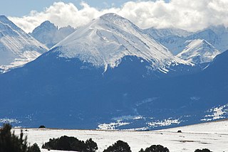
The Sangre de Cristo Mountains are the southernmost subrange of the Rocky Mountains. They are located in southern Colorado and northern New Mexico in the United States. The mountains run from Poncha Pass in South-Central Colorado, trending southeast and south, ending at Glorieta Pass, southeast of Santa Fe, New Mexico. The mountains contain a number of fourteen thousand foot peaks in the Colorado portion, as well as all the peaks in New Mexico which are over twelve thousand feet.

<span class="mw-page-title-main">Blanca Peak</span> Mountain in Colorado, United States

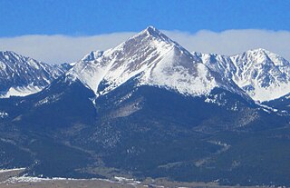
Blanca Peak is the fourth highest summit of the Rocky Mountains of North America and the U.S. state of Colorado. The ultra-prominent 14,351-foot (4,374 m) peak is the highest summit of the Sierra Blanca Massif, the Sangre de Cristo Range, and the Sangre de Cristo Mountains. The fourteener is located 9.6 miles (15.5 km) north by east of the Town of Blanca, on the drainage divide separating Rio Grande National Forest and Alamosa County from the Sangre de Cristo Land Grant and Costilla County. The summit is the highest point of both counties and the entire drainage basin of the Rio Grande. Below the steep North Face of Blanca Peak two live Glaciers once developed, until extinction sometime after 1903. North & South Blanca Glaciers were located at 37° 35N.,longitude 105° 28W. Blanca Peak is higher than any point in the United States east of its longitude.

<span class="mw-page-title-main">Crestone Peak</span>

Crestone Peak is the seventh-highest summit of the Rocky Mountains of North America and the U.S. state of Colorado. The prominent 14,300-foot (4,359 m) fourteener is the highest summit of the Crestones and the second-highest summit in the Sangre de Cristo Range after Blanca Peak. The summit is located in the Sangre de Cristo Wilderness of Rio Grande National Forest, 5.0 miles (8.1 km) east by south of the Town of Crestone in Saguache County, Colorado, United States.

<span class="mw-page-title-main">Humboldt Peak (Colorado)</span>

Humboldt Peak is a high mountain summit of the Crestones in the Sangre de Cristo Range of the Rocky Mountains of North America. The 14,070-foot (4,289 m) fourteener is located in the Sangre de Cristo Wilderness of San Isabel National Forest, 11.9 miles (19.2 km) south-southwest of the Town of Westcliffe in Custer County, Colorado, United States.

<span class="mw-page-title-main">Wet Mountains</span> Mountain range in southern Colorado, United States

The Wet Mountains are a small mountain range in southern Colorado, named for the amount of snow they receive in the winter as compared to the dried Great Plains to the east. They are a sub-range of the Sangre de Cristo Mountains, in the southern Rocky Mountains System. There are three variant names of mountain range: Cuerno Verde, Greenhorn Mountains, and Sierra Mojada.

Rosita was a silver mining town — now a ghost town — in Custer County, Colorado, United States. Rosita is Spanish for little rose. Although the old town has almost entirely disappeared, the surrounding area has been largely developed into semi-rural home sites.

Querida is a ghost town in Custer County, Colorado, United States. The town was built to serve the surrounding silver mines, the most important of which was the Bassick mine. Querida is Spanish for "beloved."

Custer County High School is a public high school located in Westcliffe, Colorado, United States.

<span class="mw-page-title-main">Sangre de Cristo Pass</span>

Sangre de Cristo Pass, elevation 9,468-foot (2,886 m), is a mountain pass in the Sangre de Cristo Mountains of the U.S. State of Colorado. The pass is located immediately north of U.S. Highway 160 one half mile northwest of North La Veta Pass. The pass separates Costilla County from Huerfano County, the Rio Grande drainage basin from the Arkansas River basin, and the headwaters of Sangre de Cristo Creek from those of Oak Creek.

<span class="mw-page-title-main">Silver Mountain (Colorado)</span> American mountain in Colorado

Silver Mountain, elevation 10,525 ft (3,208 m), is a mountain in Huerfano County, Colorado. It is part of the southern Sangre de Cristo Range of the Southern Rocky Mountains of North America. Silver Mountain is located northeast of Mount Mestas and north of the Spanish Peaks.

<span class="mw-page-title-main">Tom Sharp (trader)</span>

William Thomas "Tom" Sharp was a former Confederate soldier and explorer who operated a trading post on the Taos Trail and founded the now extinct town of Malachite, Colorado. It was located on the Huerfano River in Huerfano County, Colorado. He became a nationally known horse and cattle breeder.

<span class="mw-page-title-main">Grape Creek (Colorado)</span> River

Grape Creek is a tributary of the Arkansas River that flows through Custer and Fremont counties in South-Central Colorado. The creek drains much of the Wet Mountain Valley, located between the Sangre de Cristo Mountains and the Wet Mountains in Custer County.

<span class="mw-page-title-main">Hardscrabble Mountain</span> Mountain in Colorado, United States

Hardscrabble Mountain is a summit located in Custer County, Colorado with an elevation of 3,171 metres (10,404 ft). It is one of the peaks in Wet Mountains, a sub-range of the Sangre de Cristo Range of the Rocky Mountains. A local legend is that the mountain was named after an event from Christmas Day 1855. Ute Native Americans attacked settlers in Pueblo, after which soldiers pursued the Utes. They ran up the creek and had a “hard scrabble” to avoid being captured.

The Sangre de Cristo Land Grant in the San Luis Valley of southern Colorado and northern New Mexico consists of 1,000,000 acres (4,000 km2) of mostly arid land. It was awarded by the government of New Mexico to the Beaubien family in 1843. The land grant was originally settled by Hispanics from New Mexico. Since the incorporation of the area of the grant into the United States in 1848, legal disputes between the descendants of the Hispanic settlers and Anglo ranchers about ownership of and access to some of the land in the grant area have been frequent and continued into the 21st century.

References

  1. "Wet Mountain Valley". Geographic Names Information System . United States Geological Survey, United States Department of the Interior.
  2. Google Earth
  3. "Data". United States Census Bureau.
  4. "Wet Mountain Valley". Trust for Public Land. Retrieved 24 October 2022.
  5. "Rosita". Ghost Towns.
  6. "Querida, Colorado". Western Mining History.
  7. Google Earth
  8. "How Westcliff and Silver Cliff became an international dark sky community". Wet Mountain Valley. Retrieved 24 October 2022.
  9. "Westcliffe, Colorado (058931)". Western Regional Climate Center. US Geologic Survey. Retrieved 24 October 2022.

Coordinates: 38°04′00″N105°26′32″W / 38.06666667°N 105.44222222°W / 38.06666667; -105.44222222