
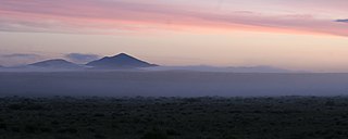
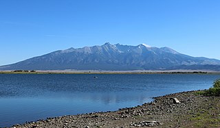
The San Luis Valley is a region in south-central Colorado with a small portion overlapping into New Mexico. The valley is approximately 122 miles (196 km) long and 74 miles (119 km) wide, extending from the Continental Divide on the northwest rim into New Mexico on the south. It contains 6 counties and portions of 3 others. It is an extensive high-elevation depositional basin of approximately 8,000 square miles (21,000 km2) with an average elevation of 7,664 feet (2,336 m) above sea level. The valley is a section of the Rio Grande Rift and is drained to the south by the Rio Grande, which rises in the San Juan Mountains to the west of the valley and flows south into New Mexico. The San Luis Valley has a cold desert climate but has substantial water resources from the Rio Grande and groundwater.

Custer County is a county located in the U.S. state of Colorado. As of the 2020 census, the population was 4,704. The county seat is Westcliffe.

Cañon City is a home rule municipality that is the county seat and the most populous municipality of Fremont County, Colorado, United States. The city population was 17,141 at the 2020 United States Census. Cañon City is the principal city of the Cañon City, CO Micropolitan Statistical Area and is a part of the Front Range Urban Corridor. Cañon City straddles the easterly flowing Arkansas River and is a popular tourist destination for sightseeing, whitewater rafting, and rock climbing. The city is known for its many public parks, fossil discoveries, Skyline Drive, The Royal Gorge railroad, the Royal Gorge, and extensive natural hiking paths. In 1994, the United States Board on Geographic Names approved adding the tilde to the official name of Cañon City, a change from Canon City as the official name in its decisions of 1906 and 1975. It is one of the few U.S. cities to have the Spanish Ñ in its name, others being La Cañada Flintridge, California; Española, New Mexico; Peñasco, New Mexico; and Peñitas, Texas.

The Royal Gorge is a canyon of the Arkansas River located west of Cañon City, Colorado. The canyon begins at the mouth of Grape Creek, about 2 mi (3.2 km) west of central Cañon City, and continues in a west-northwesterly direction for approximately 6 mi (9.7 km) until ending near U.S. Route 50. Being one of the deepest canyons in Colorado, it is also known as the Grand Canyon of the Arkansas (River), with a maximum depth of 1,250 ft (380 m). The canyon is also very narrow, measuring from 50 ft (15 m) wide at its base to 300 ft (91 m) wide at its top, as it carves a path through the granite formations below Fremont Peak and YMCA Mountain, which rise above the north and south rims, respectively.

Great Sand Dunes National Park and Preserve is a national park of the United States that conserves an area of large sand dunes on the eastern edge of the San Luis Valley, and an adjacent national preserve in the Sangre de Cristo Range, in south-central Colorado. The park was originally designated Great Sand Dunes National Monument on March 17, 1932, by President Herbert Hoover. The original boundaries protected an area of 35,528 acres. A boundary change and redesignation as a national park and preserve was authorized on November 22, 2000, and then established on September 24, 2004. The park encompasses 107,342 acres while the preserve protects an additional 41,686 acres for a total of 149,028 acres. The recreational visitor total was 527,546 in 2019.

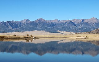
The Wet Mountain Valley is a high elevation mountain valley mostly located in Custer County but extending southward into Huerfano County in south-central Colorado. Westcliffe and Silver Cliff are the two towns in the valley which is mostly devoted to cattle ranching.

San Isabel National Forest is located in central Colorado. The forest contains 19 of the state's 53 fourteeners, peaks over 14,000 feet (4,267 m) high, including Mount Elbert, the highest point in Colorado.
The Wet Mountains are a small mountain range in southern Colorado, named for the amount of snow they receive in the winter as compared to the dry Great Plains to the east. They are a sub-range of the Sangre de Cristo Mountains, in the southern Rocky Mountains System. There are three variant names of mountain range: Cuerno Verde, Greenhorn Mountains, and Sierra Mojada.

Coaldale is a census-designated place (CDP) and post office located in and governed by Fremont County, Colorado, United States. The CDP is a part of the Cañon City, CO Micropolitan Statistical Area. The Coaldale post office has the ZIP Code 81222. At the United States Census 2020, the population of the Coaldale CDP was 343.

U.S. Route 50 (US 50) is a part of the U.S. Highway System that travels from West Sacramento, California, to Ocean City, Maryland. In the U.S. state of Colorado, US 50 is a major highway crossing through the lower midsection of the state. It connects the Western Slope with the lower Front Range. The highway serves the areas of Pueblo and Grand Junction as well as many other smaller areas along its corridor. The long-term project to widen the highway from two lanes to a four lane expressway between Grand Junction and Montrose was completed in January 2005. Only about 25% of the remainder of highway 50 in Colorado is four lane highway.
Coyote Creek State Park is a state park of New Mexico, United States, preserving a riparian canyon in the Sangre de Cristo Mountains. The park is located 17 miles (27 km) north of Mora. Coyote Creek is the most densely stocked trout stream in New Mexico.

Trinchera Creek is a tributary of the Rio Grande in Costilla County, Colorado in the United States. It flows west from a source in the Sangre de Cristo Mountains to a confluence with the Rio Grande.

Raton Mesa is the name of the mesa that overlooks the town of Trinidad and is located in Las Animas County, Colorado. The highest point of Raton Mesa is Fishers Peak. In 1967, the Department of the Interior designated it as a National Natural Landmark.
DeWeese Reservoir is located in northern Custer County, Colorado between the Sangre de Cristo Mountains and the Wet Mountains. The reservoir is owned by the DeWeese-Dye Ditch and Reservoir Company, which uses the water it stores to irrigate agricultural crops around Lincoln Park and Brookside in Fremont County, Colorado.
Smith Reservoir is located in Costilla County, Colorado, south of Blanca in the San Luis Valley. The reservoir is owned by the Trinchera Irrigation Company.

Horn Peak is a 13,450-foot (4,100 m) mountain summit in Custer County, Colorado, United States.

Spread Eagle Peak is a 13,423-foot (4,091 m) mountain summit in Custer County, Colorado, United States.

Eureka Mountain is a 13,507-foot (4,117 m) mountain summit on the boundary shared by Custer and Saguache counties, in Colorado, United States.

Early history of Fremont County, Colorado includes Native Americans, such as the Ute people, and later the establishment of the Colorado Territory by European explorers and settlers.

