The Wetterstein mountains, colloquially called Wetterstein, is a mountain group in the Northern Limestone Alps within the Eastern Alps. It is a comparatively compact range located between Garmisch-Partenkirchen, Mittenwald, Seefeld in Tirol and Ehrwald along the border between Germany (Bavaria) and Austria (Tyrol). Zugspitze, the highest peak is at the same time the highest mountain in Germany.

Garmisch Classic is an alpine ski area in the Bavarian Alps of southern Germany, near Garmisch-Partenkirchen, Bavaria. Its maximum elevation is 2,050 m (6,726 ft) above sea level at Osterfelderkopf, with a vertical drop of 1,350 m (4,429 ft). Other peaks of area are the Kreuzjoch at 1,719 m (5,640 ft) and Kreuzeck at 1,651 m (5,417 ft).

The Zugspitzebahn was the first wire ropeway to open the summit of the Zugspitze, Germany's highest mountain on the border of Austria. Designed and built by Adolf Bleichert & Co. of Leipzig, Germany, the system was a record-holder for highest altitude. Opening in 1926, the Zugspitzebahn connected the Austrian town of Ehrwald with the top station at 2,950 metres above sea level next to the summit of Zugspitze.
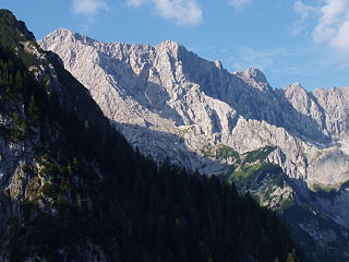
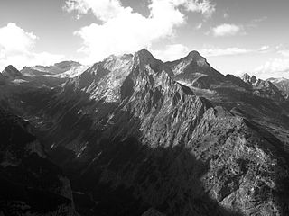
The Höllentalspitzen are three peaks in the Wetterstein Mountains near Garmisch-Partenkirchen in southern Germany. They rise from the ridge of Blassenkamm which runs eastwards from Germany's highest peak, the Zugspitze, and separate the Hölle Valley to the north from the Reintal Valley to the south. The summit nearest to the Zugspitze is the Inner Höllentalspitze, 2,741 metres (8,993 ft) high; this is followed by the main summit Middle Höllentalspitze, 2,743 metres (8,999 ft) high; and the Outer Höllentalspitze at 2,720 metres (8,920 ft).

The Wetterspitzen are three of the rocky peaks on a mountain ridge in the Wetterstein mountains in the central part of the Eastern Alps in Germany. They lie two kilometres, as the crow flies, southwest of Germany's highest peak, the Zugspitze, on the border between the Austrian province of Tyrol and the German state of Bavaria. The Wetterspitzen form the southwest perimeter of the Zugspitze ledge (Zugspitzplatt); below and to the east is the ski region on the Schneeferner with its research station, the Schneefernerhaus.

The Schneefernerkopf is a 2,875-metre-high (9,432 ft) peak in the Zugspitze massif in the Alps. It lies at the western end of the Wetterstein chain in the Alps on the border between the German state of Bavaria and the Austrian state of Tyrol. It is the dominant mountain in the Wetterstein, especially when viewed from Ehrwald.
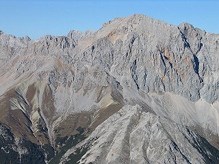
At 2,744 metres (9,003 ft), the Hochwanner is the second highest mountain in Germany after the Zugspitze. In addition the Hochwanner is the highest peak on the main ridge of the Wetterstein (Wettersteinhauptkamm) running from Gatterl to the Upper Wettersteinspitze above Mittenwald in an east-west direction. From the Hochwanner massif there is an all-round view of the Rein valley (Reintal), the Leutasch valley in Austria, the Gais valley, the Zugspitze, the Mieming Chain, the Jubiläumsgrat, the Karwendel mountains and far into the central Alps.

Dreitorspitze is a large and very prominent, multi-peak mountain massif in the eastern part of the Wetterstein Mountains in southern Germany. It is divided into Partenkirchen Dreitorspitze at 2,633 metres (8,638 ft) and Leutasch Dreitorspitze at 2,682 metres (8,799 ft); each of which has several peaks. The main peak of the fourth highest mountain massif in Germany is the Leutasch Dreitorspitze, which is also known as the Karlspitze. The Dreitorspitze marks the spot where the main chain of the Wetterstein mountains changes direction from its primary east-west orientation to run northwards for a short distance, before turning back again onto its main axis. East of the Dreitorspitze lies the karst plateau of the Leutasch Platt, comparable to the Zugspitzplatt at the foot of the Zugspitze.
The Hochblassen is a mountain 2,706 metres (8,878 ft) high, located in the Wetterstein in the German state of Bavaria. In addition to the main summit, it has a sub-peak, the so-called Signalgipfel which is 2,698 metres (8,852 ft) high. It was first climbed in 1871 by Hermann von Barth and Peter Klaisl.

The Große Arnspitze is the highest peak in the Arnspitze Group in the Wettersteingebirge mountains. It is located west of Scharnitz in Austria. The border between Germany and Austria runs over its summit.

The Hocheisspitze is a 2,523 m high mountain in the Berchtesgaden Alps, over which the border between Germany and Austria runs. It is also the highest mountain in the eponymous Hocheis Group that belongs to the Hochkalter Massif.

The Östliche Karwendelspitze is a mountain formed from Wetterstein limestone in the Karwendel mountains on the border between Bavaria and Tyrol. It is the highest mountain of the Northern Karwendel chain and the highest German peak in the Karwendel. It was first climbed by Hermann von Barth on 4 July 1870.

The Plattspitzen is a 2,680-metre-high (8,790 ft) mountain in the Wetterstein Mountains on the border between Germany and Austria. It is a very striking mountain and the southern companion of Germany's highest peak, the Zugspitze, located at the opposite end of the ledge known as the Plattumrahmung. The mountain has three summits: the eastern summit, known as the Gatterlspitz, the middle summit and the western summit. It was first climbed in 1871 by Hermann von Barth, who conquered all three peaks alone departing from the Zugspitzplatt ledge. At that time the mountain was also known as the Wetterschrofen.

The Bavarian Zugspitze Railway is one of four rack railways still working in Germany, along with the Wendelstein Railway, the Drachenfels Railway and the Stuttgart Rack Railway. The metre gauge line runs from Garmisch in the centre of Garmisch-Partenkirchen to the Zugspitzplatt, approximately 300 metres below Zugspitze, the highest mountain in Germany. The line culminates at 2,650 metres above sea level, which makes it the highest railway in Germany and the third highest in Europe. It is also the railway in Europe with the biggest height difference: 1,945 metres, the lower half being open-air and the upper half being underground.

The Münchner Haus on Germany's highest mountain, the Zugspitze, is an Alpine Club hut belonging to the Munich Section of the German Alpine Club (DAV).

The Knorr Hut is a mountain hut belonging to the German Alpine Club and located in the Wetterstein Mountains at a height of 2,052 m. Its lies right on the edge of the Zugspitzplatt where it drops into the Reintalanger in a location with scenic views and is an important base for hikers who can climb up to it on the normal route from the town of Garmisch-Partenkirchen through the Reintal valley to Germany’s highest mountain, the Zugspitze.