
San Luis Obispo County, officially the County of San Luis Obispo, is a county on the Central Coast of California. As of the 2020 census, the population was 282,424. The county seat is San Luis Obispo.

Cayucos is an unincorporated coastal town in San Luis Obispo County, California, along California State Route 1 between Cambria to the north and Morro Bay to the south. The population was 2,505 at the 2020 census, down from 2,592 at the 2010 census.

Morro Bay is a seaside city in San Luis Obispo County, California. Located on the Central Coast of California, the city population was 10,757 as of the 2020 census, up from 10,234 at the 2010 census. The town overlooks Morro Bay, a natural embayment with an all-weather small craft commercial and recreational harbor.

San Luis Obispo is a city and county seat of San Luis Obispo County, in the U.S. state of California. Located on the Central Coast of California, San Luis Obispo is roughly halfway between the San Francisco Bay Area in the north and Greater Los Angeles in the south. The population was 47,063 at the 2020 census.

The Governor Edmund G. Brown California Aqueduct is a system of canals, tunnels, and pipelines that conveys water collected from the Sierra Nevada Mountains and valleys of Northern and Central California to Southern California. Named after California Governor Edmund Gerald "Pat" Brown Sr., the over 400-mile (640 km) aqueduct is the principal feature of the California State Water Project.

Lake Nacimiento is an 18-mile (29 km) long lake on the Nacimiento River in northern San Luis Obispo County, California. The lake contains many arms including Snake Creek and Dip Creek, nearer the dam, and the central Las Tablas and Franklin Creeks. Due to the dragon-like shape created by the positions of these arms, it is sometimes referred to as Dragon Lake.
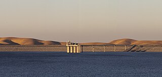
San Luis Dam, also known as B.F. Sisk Dam, is a major earth-filled dam in Merced County, California, which forms San Luis Reservoir, the largest off-stream reservoir in the United States. The dam and reservoir are located in the Diablo Range to the east of Pacheco Pass and about 10 miles (16 km) west of Los Banos. San Luis Dam, a jointly-owned state and federal facility, stores more than 2 million acre feet (2.5 km3) of water for the California State Water Project and the federal Central Valley Project. Although the dam is located in the valley of San Luis Creek, the majority of its water comes from man-made aqueducts which are supplied from other rivers in Northern California.

The California Department of Water Resources (DWR) is part of the California Natural Resources Agency and is responsible for the management and regulation of the State of California's water usage. The department was created in 1956 by Governor Goodwin Knight following severe flooding across Northern California in 1955, where they combined the Division of Water Resources of the Department of Public Works with the State Engineer's Office, the Water Project Authority, and the State Water Resources Board. It is headquartered in Sacramento.
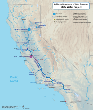
The California State Water Project, commonly known as the SWP, is a state water management project in the U.S. state of California under the supervision of the California Department of Water Resources. The SWP is one of the largest public water and power utilities in the world, providing drinking water for more than 27 million people and generating an average of 6,500 GWh of hydroelectricity annually. However, as it is the largest single consumer of power in the state itself, it has a net usage of 5,100 GWh.

Cayucos State Beach is a protected beach in the state park system of California, United States. It is located in Cayucos, San Luis Obispo County. The sandy beach environment supports uses of swimming and surfing. Prehistorically this general area of the central coast was inhabited by the Chumash people, who settled the coastal San Luis Obispo area approximately 10,000 to 11,000 BCE, including a large village to the south of Cayucos at Morro Creek. The 16-acre (6.5 ha) park was established in 1940.
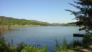
Santa Margarita Lake, also called Salinas Reservoir, is a lake several miles southeast of the town of Santa Margarita in San Luis Obispo County, California. The lake was created by the building of Salinas Dam on the southern end of the Salinas River, very close to the river's origin in the Santa Lucia Range.

Lopez Lake is a reservoir near the city of Arroyo Grande in San Luis Obispo County, California. The lake is formed by Lopez Dam on Arroyo Grande Creek, 9 mi (14 km) upstream from the Pacific Ocean. The creek drains about 60 sq mi (160 km2) above the dam and 90 sq mi (230 km2) below. The dam was built in 1969 and is operated by the San Luis Obispo County Flood Control and Water Conservation District. The earth-fill dam was retrofitted to protect against earthquakes between 2001 and 2003. The winter of 2022-2023 brought the reservoir to the capacity of 49,200 acre-feet (60,700,000 m3). In March 2023 the lake overflowed into the spillway for the first time since 1998, some 25 years prior.
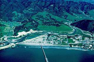
San Luis Obispo Creek is a stream, about 18 miles (29 km) long, in San Luis Obispo County, California. It drains a large coastal watershed that includes the city of San Luis Obispo, emptying into the Pacific Ocean at Avila Beach.

Twitchell Reservoir is a reservoir in southern San Luis Obispo County and northern Santa Barbara County in California. The reservoir has a capacity of 197,756 acre⋅ft (243,928,000 m3) and is formed by Twitchell Dam on the Cuyama River about 66 miles (106 km) from its headwaters in the Chumash Wilderness Area. About 7 miles (11 km) below the dam, outflow joins the Sisquoc River near Garey, CA to form the Santa Maria River.

The Cuyama River is a 118-mile-long (190 km) river in southern San Luis Obispo County, northern Santa Barbara County, and northern Ventura County, in the U.S. state of California. It joins the Sisquoc River forming the Santa Maria River. The river's name comes from an Indian village named for the Chumash word kuyam, meaning "clam" or "freshwater mollusk".

Estero Bluffs State Park is a state park of California, United States, on Estero Bay. The park protects a grassland-dominated marine terrace that slopes from California State Route 1 to the Pacific Ocean. The property is crossed by San Geronimo and Villa Creeks and is just north of the town of Cayucos. The 353-acre (143 ha) park was established in 2000.
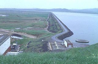
O'Neill Dam is an earthfill dam on San Luis Creek, 12 miles (19 km) west of Los Banos, California, United States, on the eastern slopes of the Pacific Coast Ranges of Merced County. Forming the O'Neill Forebay, a forebay to the San Luis Reservoir, it is roughly 2.5 miles (4.0 km) downstream from the San Luis Dam.

Nacimiento Dam is a dam on the Nacimiento River about 10 miles (16 km) northwest of Paso Robles, California in the United States. The primary purpose of the dam is to provide groundwater recharge for agriculture in Monterey County and northern San Luis Obispo County supported by the Salinas Valley aquifer, as well as flood control, domestic water supply, and hydropower. It forms Lake Nacimiento, popular for boating, fishing and camping, and known locally as the "Dragon Lake" due to its shape.

The Salinas Dam is a dam built on the Salinas River in San Luis Obispo County, California. Designed by Raymond A. Hill, the gravity dam features an arched design with an open spillway. The War Department began construction on the dam in mid-1941, as World War II began to reach the Pacific. The original intent of the dam was to supply water to Camp San Luis Obispo, which the Army was considering expanding to meet military needs. However, the camp’s wells ultimately provided sufficient water to the camp, and the reservoir water was never required or used by the military. Today, the dam operations are leased by the city of San Luis Obispo, to supply water to the city and surrounding agricultural areas. The reservoir created by the dam is known as the Santa Margarita Lake, or Santa Margarita Reservoir.

Arroyo Grande Creek is a major stream in San Luis Obispo County on the Central Coast of California. The creek flows 22 miles (35 km) in a southwesterly direction, from the Santa Lucia Range to the Pacific Ocean. It is a major source of water supply for southern San Luis Obispo County.


