Cayucos, California | |
---|---|
Nickname: Little Slice of Paradise [1] | |
Motto: Last of the California beach towns [2] | |
Coordinates: 35°26′18″N120°53′37″W / 35.43833°N 120.89361°W | |
Country | United States |
State | California |
County | San Luis Obispo |
Area | |
• Total | 4.03 sq mi (10.45 km2) |
• Land | 3.10 sq mi (8.03 km2) |
• Water | 0.93 sq mi (2.42 km2) 10.85% |
Elevation | 75 ft (23 m) |
Population (2020) | |
• Total | 2,505 |
• Density | 808.06/sq mi (312.00/km2) |
Time zone | UTC-8 (Pacific (PST)) |
• Summer (DST) | UTC-7 (PDT) |
ZIP code | 93430 |
Area code | 805 |
FIPS code | 06-12132 |
GNIS feature IDs | 1656455, 2407994 |
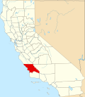
Cayucos (Spanish for "Canoes") is an unincorporated coastal town in San Luis Obispo County, California, along California State Route 1 between Cambria to the north and Morro Bay to the south. The population was 2,505 at the 2020 census, down from 2,592 at the 2010 census.
The area was settled by the Chumash people approximately 11000 to 10000 BC. It included a large village to the south of Cayucos at Morro Creek. [6]
The first European land exploration of Alta California, the Spanish Portolà expedition, camped in the vicinity of today's Cayucos on September 9, 1769. Coming from the previous campsite near Morro Bay, Franciscan missionary and expedition member Juan Crespi noted in his diary that "In the four hours that we traveled, making at the most three leagues, we encountered eight arroyos by which the water from the mountains runs to the sea, along whose edge we traveled. We halted at the eighth watering place in a moderately broad valley, into which enters an estuary fed by an arroyo of good water coming from the mountains." [7] Crespi translator Herbert Bolton noted the camp location as Ellysley Creek (further along the coast to the northwest), but the description sounds more like Cayucos.
Cayucos is named for the cayuco, a Spanish name for a small canoe. It was named after the canoes used by the Chumash people to fish in the bay, particularly in the rich kelp beds just north of the current Cayucos pier. The town took its name from the old Rancho Moro y Cayucos, a Mexican land grant awarded in 1842 that includes the present area of the town.
In 1867, Captain James Cass settled on 320 acres (1.29 km2) of this land, and founded the town of Cayucos. Cass began developing the area with his business partner, Captain Ingals. Cass built a 900-foot pier and a warehouse to house cargo bound for San Francisco or Los Angeles. Eventually Cass returned to life on the sea and in 1875 real estate developer C.H. Phillips subdivided and sold the remaining portions of Rancho Moro y Cayucos. The original pier was swept away by a storm but has since been rebuilt. [8]
On December 7, 1987, Pacific Southwest Airlines Flight 1771, bound from Los Angeles International Airport to San Francisco, was cruising above the central California coast when a recently terminated disgruntled USAir employee aboard the plane shot his ex-supervisor, both pilots, a flight attendant and presumably PSA's chief pilot, before deliberately inducing a steep nosedive with the aircraft. The aircraft slammed into a hillside just east of Cayucos at 770 mph (1,239 km/h). [9] All 43 passengers and crew aboard perished. [10]
In October 2009, Arthur Frommer's Budget Travel Magazine listed Cayucos as one of the "Coolest Small Towns in America". [11]
Cayucos is located at 35°26′18″N120°53′26″W / 35.43833°N 120.89056°W (35.438390, -120.890647). [12]
According to the United States Census Bureau, the CDP has a total area of 3.5 square miles (9.1 km2), of which, 3.1 square miles (8.0 km2) of it is land and 0.4 square miles (1.0 km2) of it (10.85%) is water.
Cayucos is home to Cayucos State Beach.
Census | Pop. | Note | %± |
---|---|---|---|
2010 | 2,592 | — | |
2020 | 2,505 | −3.4% | |
U.S. Decennial Census [13] 1850–1870 [14] [15] 1880-1890 [16] 1900 [17] 1910 [18] 1920 [19] 1930 [20] 1940 [21] 1950 [22] 1960 [23] 1970 [24] 1980 [25] 1990 [26] 2000 [27] 2010 [28] |
The 2010 United States Census [29] reported that Cayucos had a population of 2,592. The population density was 745.4 inhabitants per square mile (287.8/km2). The racial makeup of Cayucos was 2,366 (91.3%) White, 6 (0.2%) African American, 12 (0.5%) Native American, 54 (2.1%) Asian, 8 (0.3%) Pacific Islander, 57 (2.2%) from other races, and 89 (3.4%) from two or more races. Hispanic or Latino of any race were 207 persons (8.0%).
The Census reported that 2,592 people (100% of the population) lived in households, 0 (0%) lived in non-institutionalized group quarters, and 0 (0%) were institutionalized.
There were 1,314 households, out of which 214 (16.3%) had children under the age of 18 living in them, 578 (44.0%) were opposite-sex married couples living together, 105 (8.0%) had a female householder with no husband present, 45 (3.4%) had a male householder with no wife present. There were 76 (5.8%) unmarried opposite-sex partnerships, and 10 (0.8%) same-sex married couples or partnerships. 471 households (35.8%) were made up of individuals, and 195 (14.8%) had someone living alone who was 65 years of age or older. The average household size was 1.97. There were 728 families (55.4% of all households); the average family size was 2.53.
The age of the population was spread out, with 337 people (13.0%) under the age of 18, 169 people (6.5%) aged 18 to 24, 488 people (18.8%) aged 25 to 44, 946 people (36.5%) aged 45 to 64, and 652 people (25.2%) who were 65 years of age or older. The median age was 53.0 years. For every 100 females, there were 91.9 males. For every 100 females age 18 and over, there were 93.2 males.
There were 2,354 housing units at an average density of 677.0 per square mile (261.4/km2), of which 781 (59.4%) were owner-occupied, and 533 (40.6%) were occupied by renters. The homeowner vacancy rate was 4.6%; the rental vacancy rate was 12.8%. 1,555 people (60.0% of the population) lived in owner-occupied housing units and 1,037 people (40.0%) lived in rental housing units.
As of the census [30] of 2000, there were 2,943 people, 1,405 households, and 809 families residing in the CDP. The population density was 954.4 inhabitants per square mile (368.5/km2). There were 2,284 housing units at an average density of 740.7 per square mile (286.0/km2). The racial makeup of the CDP was 93.82% White, 6.80% Hispanic or Latino (of any race), 2.17% from two or more races, 2.11% from other races, 1.26% Asian, 0.37% Native American, 0.24% African American, and 0.03% Pacific Islander.
There were 1,405 households, out of which 19.6% had children under the age of 18 living with them, 46.4% were married couples living together, 7.5% had a female householder with no husband present, and 42.4% were non-families. 33.6% of all households were made up of individuals, and 13.2% had someone living alone who was 65 years of age or older. The average household size was 2.08 and the average family size was 2.62.
In the CDP, the population was spread out, with 16.8% under the age of 18, 6.5% from 18 to 24, 24.4% from 25 to 44, 28.7% from 45 to 64, and 23.5% who were 65 years of age or older. The median age was 46 years. For every 100 females, there were 91.7 males. For every 100 females age 18 and over, there were 91.1 males.
The median income for a household in the CDP was $42,841, and the median income for a family was $53,594. Males had a median income of $35,333 versus $31,359 for females. The per capita income for the CDP was $26,525. About 2.4% of families and 8.2% of the population were below the poverty line, including 7.1% of those under age 18 and 4.0% of those age 65 or over.
In the California State Legislature, Cayucos is in the 17th State Senate District and the 35th Assembly District. [31]
In the United States House of Representatives, Cayucos is in California's 24th congressional district , represented by Democrat Salud Carbajal. [32]
Tourism plays a big role in the downtown Cayucos economy.
The Cayucos Pier is a popular surf spot and one of the best in the county, attracting many beachgoers.
Cayucos has its own Chamber of Commerce and website.
Cayucos is home to many small businesses, such as Cayucos Collective and restaurants, such as The Hidden Kitchen and Schooners.
Arbuckle is a census-designated place (CDP) in Colusa County, California, United States. The population was 3,028 at the 2010 census, up from 2,332 at the 2000 census. Arbuckle is situated in the southerly portion of Colusa County, approximately 20 miles (32 km) southwest of the City of Colusa, the county seat. The town is characterized by single-family residences, multiple-family units, some mobile homes, and commercial activities. Land surrounding Arbuckle is agriculture including cultivated annual crops, and both active and unmaintained orchards. Various almond hullers may be found near the area. Regional access is provided by the north–south running Interstate 5, along with Old Highway 99 West running alongside Interstate 5.
Bowles is a census-designated place (CDP) in Fresno County, California, United States. The population was 166 at the 2010 census, down from 182 at the 2000 census. Bowles is located 11 miles (18 km) south of downtown Fresno, at an elevation of 279 feet.
Cantua Creek is a census-designated place (CDP) in Fresno County, California, United States. As of the 2010 census, the population was 466, down from the 655 reported at the 2000 census. Cantua Creek is located 11 miles (18 km) south-southwest of Tranquillity, at an elevation of 295 feet.
Caruthers is a census-designated place (CDP) in Fresno County, California, United States. The population was 2,497 at the 2010 census, up from 2,103 at the 2000 census. Caruthers is located 15 miles (24 km) south of downtown Fresno, at an elevation of 246 feet.
Bayview is a census-designated place (CDP) located adjacent to the City of Eureka in Humboldt County, California, United States. Its population is 2,619 as of the 2020 census, up from 2,510 from the 2010 census. Many locals consider this area as part of "Pine Hill."
Clearlake Oaks is a census-designated place (CDP) in Lake County, California, United States. It is located on the northeast of Clear Lake, 8 miles (13.8 km) northwest of the town of Clearlake, at an elevation of 1,335 feet. The population was 2,359 at the 2010 census, down from 2,402 at the 2000 census.
Aromas is an unincorporated community and census-designated place (CDP) in Monterey County and San Benito County, California, United States. The population was 2,708 at the 2020 census.
Clio is a census-designated place in Plumas County, California, United States. Clio is located 23 miles (37.0 km) southeast of Quincy. The population was 77 at the 2020 census, up from 66 at the 2010 census.
Big River is a census-designated place (CDP) in San Bernardino County, California, United States. The population was 1,084 at the 2020 census, down from 1,327 at the 2010 census.
Bluewater is a census-designated place (CDP) in San Bernardino County, California, United States. The population was 172 at the 2010 census, down from 265 at the 2000 census.
Bonsall is a census-designated place (CDP) in San Diego County, California. The population was 3,982 at the 2010 census, up from 3,401 at the 2000 census.
Camp Pendleton Mainside is a census-designated place (CDP) in San Diego County, California, located at the southeast corner of the Marine Corps Base Camp Pendleton. Per the 2020 census, the population was 9,683. It was formerly known as Camp Pendleton North, but its name was changed for the 2020 Census. Along with Camp Pendleton South, it is one of two CDPs located on the base.
Cambria is a seaside village in San Luis Obispo County, California, United States midway between San Francisco and Los Angeles along California State Route 1. The name Cambria, chosen in 1869, is the Latin name for Wales. Cambria is situated amidst Monterey pines in one of only three such native forests. The town previously had gone by the names of Slabtown, Rosaville, San Simeon, and Santa Rosa.
Aptos Hills-Larkin Valley is an unincorporated community in Santa Cruz County, California, United States. It is identified as one of several small communities with a combined population of 24,402 forming the unincorporated town of Aptos by the local Chamber of Commerce along with:
Cottonwood is a census-designated place (CDP) in Shasta County, California, United States. Its population is 6,268 as of the 2020 census, up from 3,316 from the 2010 census. Cottonwood was a stagecoach town where a settlement was established in 1849. The first Post Office was opened in 1852. Cottonwood is equidistant between Redding and Red Bluff, 15 miles (24 km) in either direction. It is 4 miles (6.4 km) south of Anderson.
China Lake Acres is a census-designated place (CDP) in Kern County, California, United States. The population was 1,876 at the 2010 census, up from 1,761 at the 2000 census.
Baywood-Los Osos is an unincorporated community in western San Luis Obispo County, California. The population was 14,351 in the 2000 census. It includes the communities of Los Osos, which is located near Morro Bay, Baywood Park, and the former community of Cuesta-by-the-Sea.
Avila Beach is an unincorporated community in San Luis Obispo County, California, United States, located on San Luis Obispo Bay about 160 miles (257 km) northwest of Los Angeles, and about 200 miles (320 km) south of San Francisco. The population was 1,576 at the 2010 census. For statistical purposes, the United States Census Bureau has defined Avila Beach as a census-designated place (CDP).
Bloomfield is a census-designated place in Sonoma County, California, U.S. It is located in a rural area about 11 miles (18 km) southwest of Santa Rosa at the junction of Bloomfield Road and Valley Ford Road. Americano Creek flows westward along the south edge of the town.
Dover-Foxcroft is a census-designated place (CDP) in the town of Dover-Foxcroft in Piscataquis County, Maine, United States. The population was 2,592 at the 2000 census.
They call Cayucos the 'Little Slice of Paradise,' as its right on the Pacific Ocean in San Luis Obispo County.
'Last of the California beach towns' is the slogan for Cayucos