Cambria Pines, California

Last updated
Cambria Pines, California
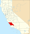
USA California location map.svg
Red pog.svg
Cambria Pines, California
Coordinates: 35°34′03″N121°05′39″W / 35.56750°N 121.09417°W / 35.56750; -121.09417 Coordinates: 35°34′03″N121°05′39″W / 35.56750°N 121.09417°W / 35.56750; -121.09417
Country United States
State California
County San Luis Obispo
Elevation
190 ft (60 m)
Time zone UTC-8 (Pacific (PST))
  Summer (DST) UTC-7 (PDT)
Area code(s) 805
GNIS feature ID1703074 [1]

Cambria Pines is an unincorporated community in San Luis Obispo County, California, United States. Cambria Pines is located along the Pacific coast north of Cambria. It is served by the Pacific Coast Highway.

Related Research Articles

San Luis Obispo County, California County in California, United States

San Luis Obispo County, officially the County of San Luis Obispo, is a county on the Central Coast of California. As of the 2010 census, the population was 269,637. The county seat is San Luis Obispo.

Santa Barbara County, California County in California

Santa Barbara County, California, officially the County of Santa Barbara, is located in Southern California. As of the 2010 census, the population was 423,895. The county seat is Santa Barbara, and the largest city is Santa Maria.

Cambria County, Pennsylvania U.S. county in Pennsylvania

Cambria County is a county located in the U.S. state of Pennsylvania. As of the 2010 census, the population was 143,679. Its county seat is Ebensburg. The county was created on March 26, 1804, from parts of Bedford, Huntingdon, and Somerset Counties and later organized in 1807. It was named for the nation of Wales, which in Latin is known as "Cambria".

Cambria, California Census designated place in California, United States

Cambria is a seaside village in San Luis Obispo County, California, United States midway between San Francisco and Los Angeles along California State Route 1. The name Cambria, chosen in 1869, is the Latin name for Wales. Cambria is situated amidst Monterey pines in one of only three such native forests. Previously, the town had gone by the names of Slabtown, Rosaville, San Simeon, and Santa Rosa. The corresponding census designated place (CDP) had a population of 6,032 at the 2010 census, slightly down from 6,232 at the 2000 census.

Cambria Township, Cambria County, Pennsylvania Township in Pennsylvania, United States

Cambria Township is a township in Cambria County, Pennsylvania, United States. The population was 6,099 at the 2010 census. It is part of the Johnstown, Pennsylvania Metropolitan Statistical Area and geographically surrounds the borough of Ebensburg, the Cambria County seat.

Loretto, Pennsylvania Borough in Pennsylvania, United States

Loretto is a borough in Cambria County, Pennsylvania, United States. As of the 2010 census it had a population of 1,302. Like the rest of Cambria County, it is part of the Johnstown, Pennsylvania Metropolitan Statistical Area. Loretto is the home of Saint Francis University.

Santa Lucia Range

The Santa Lucia Mountains or Santa Lucia Range is a rugged mountain range in coastal central California, running from Carmel southeast for 140 miles (230 km) to the Cuyama River in San Luis Obispo County. The range is never more than 11 miles (18 km) from the coast. The range forms the steepest coastal slope in the contiguous United States. Cone Peak at 5,158 feet (1,572 m) tall and three miles (5 km) from the coast, is the highest peak in proximity to the ocean in the lower 48 United States. The range was a barrier to exploring the coast of central California for early Spanish explorers.

Tahoe National Forest U.S. National Forest in California

Tahoe National Forest is a United States National Forest located in California, northwest of Lake Tahoe. It includes the 8,587-foot (2,617 m) peak of Sierra Buttes, near Sierra City, which has views of Mount Lassen and Mount Shasta. It is located in parts of six counties: Sierra, Placer, Nevada, Yuba, Plumas and El Dorado. The forest has a total area of 871,495 acres. Its headquarters is in Nevada City, California. There are local ranger district offices in Camptonville, Foresthill, Sierraville and Truckee.

Plumas National Forest National Forest in northern California, United States

Plumas National Forest is a 1,146,000-acre (4,638 km2) United States National Forest located at the northern terminus of the Sierra Nevada, in northern California. The Forest was named after its primary watershed, the Rio de las Plumas, or Feather River.

California Coast Ranges Mountain range

The Coast Ranges of California span 400 miles (644 km) from Del Norte or Humboldt County, California, south to Santa Barbara County. The other three coastal California mountain ranges are the Transverse Ranges, Peninsular Ranges and the Klamath Mountains.

California oak woodland

California oak woodland is a plant community found throughout the California chaparral and woodlands ecoregion of California in the United States and northwestern Baja California in Mexico. Oak woodland is widespread at lower elevations in coastal California; in interior valleys of the Coast Ranges, Transverse Ranges and Peninsular Ranges; and in a ring around the California Central Valley grasslands. The dominant trees are oaks, interspersed with other broadleaf and coniferous trees, with an understory of grasses, herbs, geophytes, and California native plants.

John E. Russell

John Edwards Russell was a U.S. Representative from Massachusetts.

USS <i>Cambria</i> (APA-36)

USS Cambria (APA-36) was a Bayfield-class attack transport acquired by the U.S. Navy for service in World War II. She was named after Cambria County, Pennsylvania

Piedras Blancas Light Station

Piedras Blancas Light Station is located at Point Piedras Blancas, about 5.5 miles (8.9 km) west by northwest of San Simeon, California. It was added to the California Coastal National Monument in 2017.

Special Operations Command Pacific

The Special Operations Command Pacific, known as SOCPAC, is a sub-unified command of the United States Department of Defense for special operations forces in the United States Indo-Pacific Command (USINDOPACOM) area of responsibility.

Cambria Air Force Station

Cambria Air Force Station is a closed United States Air Force General Surveillance Radar station. It is located 3 miles (4.8 km) south-southeast of Cambria, California. It was closed in 1980.

Monterey Peninsula

The Monterey Peninsula is located on the central California coast and comprises the cities of Monterey, Seaside, Carmel, Marina, and Pacific Grove, and unincorporated areas of Monterey County including the resort and community of Pebble Beach.

MV <i>Cape Pine</i>

MV Cape Pine is a charter boat operated by the Maritime Heritage Society of Vancouver. She began life as USS SC-715, a SC-497-class submarine chaser of the United States Navy. She was later transferred to the United States Coast Guard and served under the name USCGC Air Killdeer. Finally sold into mercantile service, as the Cape Pine, she worked as a high-endurance fish packer in the fisheries of the Canadian coast, and was then sold to the Maritime Heritage Society of Vancouver.

Kenneth S. Norris Rancho Marino Reserve

Kenneth S. Norris Rancho Marino Reserve is part of the University of California Natural Reserve System. The reserve is located along the coast of San Luis Obispo County at the south end of the town of Cambria, California. It is named for Kenneth S. Norris, a University of California professor, renowned naturalist, and founder of the UC Natural Reserve System. It is operated by the University under a use agreement, as it is privately owned and funded. There is no public access.

References

  1. "US Board on Geographic Names". United States Geological Survey. 2007-10-25. Retrieved 2008-01-31.