
Redway is a census-designated place (CDP) in Humboldt County, California, United States. Redway is located 2.25 miles (3.6 km) northwest of Garberville, at an elevation of 538 feet (164 m). The population was 1,225 at the 2010 census, up from 1,188 at the 2000 census. Redway is also home to Redway Elementary School, with grades K–6.

Mountain Mesa is a census-designated place (CDP) in Kern County, California, United States. Mountain Mesa is located 2 miles (3.2 km) west of South Lake at an elevation of 2,641 feet (805 m). The population was 777 at the 2010 census, up from 716 at the 2000 census.

Desert View Highlands is a census-designated place (CDP) in Los Angeles County, California, United States. The population was 2,360 at the 2010 census, up from 2,337 at the 2000 census. It is surrounded by the City of Palmdale.
North El Monte is a census-designated place (CDP) in the San Gabriel Valley, in Los Angeles County, California, United States. The population was 3,723 at the 2010 census, up from 3,703 at the 2000 census.
Green Acres is a census-designated place in Riverside County, California. Green Acres sits at an elevation of 1,555 feet (474 m). The 2010 United States census reported Green Acres's population was 1,805.

Clearlake Riviera is a census-designated place in Lake County, California. It lies at an elevation of 1755 feet. The population was 3,090 at the 2010 census.

Kingvale is a census-designated place (CDP) in Placer County and Nevada County, California, United States. The CDP straddles the border of the two counties, with Nevada County to the north and Placer County to the south. It is located near Soda Springs, 5.5 mi (8.9 km) west of Donner Pass. Kingvale was listed on an official map as of 1955. The population was 143 at the 2010 census.
San Pasqual is a census-designated place in Los Angeles County, California. It lies between San Marino and Pasadena. The major streets in San Pasqual are San Pasqual Street, South Sierra Madre Blvd., and Oakdale Street. San Pasqual is served by the Pasadena post office responsible for ZIP code 91107, and thus locations there are properly addressed with the final line reading "Pasadena, CA 91107". The population was 2,041 at the 2010 census.
Hasley Canyon is a census-designated place in Los Angeles County, California. Hasley Canyon sits at an elevation of 1,765 feet (538 m). The 2010 United States census reported Hasley Canyon's population was 1,137.
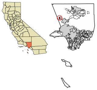
South Monrovia Island is a census-designated place in Los Angeles County, California. It sits at an elevation of 384 feet (117 m). It is bounded to the west and north by Monrovia, to the east by Duarte, and to the south by Irwindale. The 2010 United States census reported that South Monrovia Island's population was 6,777.
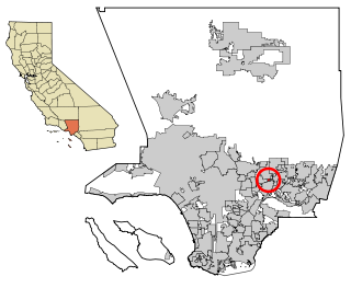
Rose Hills is a census-designated place in Los Angeles County, California. Rose Hills sits at an elevation of 518 feet (158 m) above sea level. The 2010 United States census reported Rose Hills's population was 2,803.

Los Ranchos is a census-designated place in San Luis Obispo County, California. Los Ranchos sits at an elevation of 256 feet (78 m). The 2010 United States census reported Los Ranchos's population was 1,477.
Panorama Heights is a census-designated place (CDP) in Tulare County, California. Panorama Heights sits at an elevation of 5,043 feet (1,537 m). The 2010 United States census reported Panorama Heights's population was 41.
Pierpoint is a census-designated place (CDP) in Tulare County, California, United States. Pierpoint sits at an elevation of 4,610 feet (1,410 m). The 2010 United States census reported Pierpoint's population was 52.
Pine Flat is a census-designated place (CDP) in Tulare County, California. Pine Flat sits at an elevation of 3,871 feet (1,180 m). The 2010 United States census reported Pine Flat's population was 166.
Plainview is a census-designated place (CDP) in Tulare County, California. Plainview sits at an elevation of 354 feet (108 m). The 2010 United States census reported Plainview's population was 945.
Rodriguez Camp is a census-designated place (CDP) in Tulare County, California. Rodriguez Camp sits at an elevation of 456 feet (139 m). The 2010 United States census reported Rodriguez Camp's population was 156.
Sugarloaf Saw Mill is a census-designated place (CDP) in Tulare County, California. Sugarloaf Saw Mill sits at an elevation of 5,440 feet (1,660 m). The 2010 United States census reported Sugarloaf Saw Mill's population was 18.
West Goshen is a census-designated place (CDP) in Tulare County, California. West Goshen sits at an elevation of 272 feet (83 m). The 2010 United States census reported West Goshen's population was 511.
Idlewild is a census-designated place (CDP) in Tulare County, California. Idlewild sits at an elevation of 3,766 feet (1,148 m). The 2010 United States census reported Idlewild's population was 43.

