Callender, California

Last updated

Callender
San Luis Obispo County California Incorporated and Unincorporated areas Callender Highlighted 0609948.svg
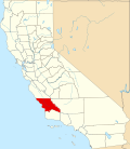
Location of Callender in San Luis Obispo County, California.
USA California location map.svg
Red pog.svg
Callender
Position in California.
Usa edcp location map.svg
Red pog.svg
Callender
Callender (the United States)
Coordinates: 35°03′11″N120°35′47″W / 35.05306°N 120.59639°W / 35.05306; -120.59639
Country Flag of the United States.svg  United States
State Flag of California.svg  California
County San Luis Obispo
Area
[1]
  Total2.29 sq mi (5.92 km2)
  Land2.29 sq mi (5.92 km2)
  Water0.00 sq mi (0.00 km2)  0%
Elevation
[2]
102 ft (31 m)
Population
 (2020)
  Total1,282
  Density560.80/sq mi (216.49/km2)
Time zone UTC-8 (Pacific (PST))
  Summer (DST) UTC-7 (PDT)
Area code 805
GNIS feature IDs252865; 2582956

Callender is a census-designated place in San Luis Obispo County, California, United States. [3] Callender is located along California State Route 1 south of Arroyo Grande. The population was 1,262 at the 2010 census.

Contents

Geography

According to the United States Census Bureau, the CDP covers an area of 2.3 square miles (5.9 km2), all of it land.

Demographics

Historical population
CensusPop.Note
2020 1,282
U.S. Decennial Census [4]

The 2010 United States Census [5] reported that Callender had a population of 1,262. The population density was 552.2 inhabitants per square mile (213.2/km2). The racial makeup of Callender was 1,003 (79.5%) White, 7 (0.6%) African American, 22 (1.7%) Native American, 48 (3.8%) Asian, 0 (0.0%) Pacific Islander, 128 (10.1%) from other races, and 54 (4.3%) from two or more races. Hispanic or Latino of any race were 355 persons (28.1%).

The Census reported that 1,262 people (100% of the population) lived in households, 0 (0%) lived in non-institutionalized group quarters, and 0 (0%) were institutionalized.

There were 439 households, out of which 144 (32.8%) had children under the age of 18 living in them, 263 (59.9%) were opposite-sex married couples living together, 39 (8.9%) had a female householder with no husband present, 27 (6.2%) had a male householder with no wife present. There were 33 (7.5%) unmarried opposite-sex partnerships, and 3 (0.7%) same-sex married couples or partnerships. 75 households (17.1%) were made up of individuals, and 22 (5.0%) had someone living alone who was 65 years of age or older. The average household size was 2.87. There were 329 families (74.9% of all households); the average family size was 3.21.

The population was spread out, with 291 people (23.1%) under the age of 18, 110 people (8.7%) aged 18 to 24, 284 people (22.5%) aged 25 to 44, 415 people (32.9%) aged 45 to 64, and 162 people (12.8%) who were 65 years of age or older. The median age was 41.8 years. For every 100 females, there were 106.5 males. For every 100 females age 18 and over, there were 107.9 males.

There were 481 housing units at an average density of 210.4 per square mile (81.2/km2), of which 289 (65.8%) were owner-occupied, and 150 (34.2%) were occupied by renters. The homeowner vacancy rate was 2.3%; the rental vacancy rate was 1.3%. 827 people (65.5% of the population) lived in owner-occupied housing units and 435 people (34.5%) lived in rental housing units.

Related Research Articles

<span class="mw-page-title-main">Riverdale, California</span> Census-designated place in California, United States

Riverdale is a census-designated place (CDP) in Fresno County, California, United States. The population was 3,153 at the 2010 census, up from 2,416 at the 2000 census. Riverdale is located 23 miles (37 km) south of Fresno, at an elevation of 223 ft (68 m).

<span class="mw-page-title-main">Homeland, California</span> Census-designated place in California, United States

Homeland is a census-designated place (CDP) in Riverside County, California, United States. The population was 5,969 at the 2010 census, up from 3,710 at the 2000 census.

<span class="mw-page-title-main">Poplar-Cotton Center, California</span> Census-designated place in California, United States

Poplar-Cotton Center is a census-designated place (CDP) in Tulare County, California, United States. The population was 2,470 at the 2010 census, up from 1,496 at the 2000 census.

Sultana is a census-designated place in Tulare County, California, United States. Sultana is 2.5 miles (4.0 km) east of Dinuba. Sultana has a post office with ZIP code 93666. The population was 775 at the 2010 census.

<span class="mw-page-title-main">Lindcove, California</span> Census-designated place in California, United States

Lindcove is a census-designated place in Tulare County, California, United States. The population was 406 at the 2010 census.

Mayfair is a census-designated place in Fresno County, California, United States. Mayfair sits at an elevation of 249 feet (76 m). The 2010 U.S. census reported Mayfair's population was 4,589.

<span class="mw-page-title-main">Desert Edge, California</span> Census-designated place in California, United States

Desert Edge is a census-designated place in Riverside County, California, United States. Desert Edge sits at an elevation of 994 feet (303 m). The 2010 United States census reported Desert Edge's population was 3,822.

Oasis is a census-designated place in the California county of Riverside. Oasis sits at an elevation of 141 feet (43 m) below sea level. The 2020 United States census reported Oasis's population was 4,468, down from 6,890 in 2010.

<span class="mw-page-title-main">Lemon Hill, California</span> Census-designated place in California, United States

Lemon Hill is a census-designated place in an unincorporated area of Sacramento County, California, south of the city of Sacramento. Lemon Hill sits at an elevation of 30 feet (9.1 m). The 2010 United States census reported Lemon Hill's population was 13,729.

<span class="mw-page-title-main">Blacklake, California</span> Place in California, United States

Blacklake is a census-designated place in San Luis Obispo County, California. Blacklake sits at an elevation of 341 feet (104 m). The 2010 United States census reported Blacklake's population was 930.

Parklawn is a census-designated place (CDP) in Stanislaus County, California. Parklawn sits at an elevation of 92 feet (28 m). The 2010 United States census reported Parklawn's population was 1,337.

<span class="mw-page-title-main">Delft Colony, California</span> Census-designated place in California, United States

Delft Colony is a census-designated place (CDP) in Tulare County, California. Delft Colony sits at an elevation of 312 feet (95 m). The 2010 United States census reported Delft Colony's population was 454.

<span class="mw-page-title-main">East Tulare Villa, California</span> Census-designated place in California, United States

East Tulare Villa is a census-designated place (CDP) in Tulare County, California. East Tulare Villa sits at an elevation of 302 feet (92 m). The 2010 United States census reported East Tulare Villa's population was 778.

Monson is a census-designated place (CDP) in Tulare County, California. Monson sits at an elevation of 325 feet (99 m). The 2010 United States census reported Monson's population was 188.

Panorama Heights is a census-designated place (CDP) in Tulare County, California. Panorama Heights sits at an elevation of 5,043 feet (1,537 m). The 2020 United States census reported Panorama Heights's population was 44, up from 41 at the 2010 census.

Pierpoint is a census-designated place (CDP) in Tulare County, California, United States. Pierpoint sits at an elevation of 4,610 feet (1,410 m). The 2010 United States census reported Pierpoint's population was 52.

Pine Flat is a census-designated place (CDP) in Tulare County, California. Pine Flat sits at an elevation of 3,871 feet (1,180 m). The 2020 United States census reported Pine Flat's population was 206, up from 166 at the 2010 census.

Plainview is a census-designated place (CDP) in Tulare County, California. Plainview sits at an elevation of 354 feet (108 m). The 2010 United States census reported Plainview's population was 945.

West Goshen is a census-designated place (CDP) in Tulare County, California. West Goshen sits at an elevation of 272 feet (83 m). The 2010 United States census reported West Goshen's population was 511.

Idlewild is a census-designated place (CDP) in Tulare County, California. Idlewild sits at an elevation of 3,766 feet (1,148 m). The 2020 United States census reported Idlewild's population was 32, down from 43 at the 2010 census.

References

  1. "2020 U.S. Gazetteer Files". United States Census Bureau. Retrieved October 30, 2021.
  2. U.S. Geological Survey Geographic Names Information System: Callender, California
  3. U.S. Geological Survey Geographic Names Information System: Callender, California
  4. "Census of Population and Housing". Census.gov. Retrieved June 4, 2016.
  5. "2010 Census Interactive Population Search: CA - Callender CDP". U.S. Census Bureau. Archived from the original on July 15, 2014. Retrieved July 12, 2014.