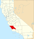
Oak Shores, California

Last updated
Oak Shores
USA California location map.svg
Red pog.svg
Oak Shores
Position in California.
Coordinates: 35°46′08″N120°58′44″W / 35.76889°N 120.97889°W / 35.76889; -120.97889
Country Flag of the United States (23px).png  United States
State Flag of California.svg  California
County San Luis Obispo
Area
[1]
  Total5.065 sq mi (13.119 km2)
  Land5.065 sq mi (13.119 km2)
  Water0 sq mi (0 km2)  0%
Elevation
[2]
1,814 ft (553 m)
Population
 (2010)
  Total337
  Density67/sq mi (26/km2)
Time zone UTC-8 (Pacific (PST))
  Summer (DST) UTC-7 (PDT)
ZIP Code
93426
GNIS feature ID2583101
U.S. Geological Survey Geographic Names Information System: Oak Shores, California

Oak Shores is a census-designated place in northern San Luis Obispo County, central California. [2]

Contents

Geography

Oak Shores is located on the north side of Lake Nacimiento reservoir. It is in the Santa Lucia Mountains, at an elevation of 1,814 feet (553 m). [2]

According to the United States Census Bureau, the CDP covers an area of 5.1 square miles (13.1 km2), all of it land.

Demographics

The 2010 United States Census [3] reported that Oak Shores had a population of 337. The population density was 66.5 inhabitants per square mile (25.7/km2). The racial makeup of Oak Shores was 318 (94.4%) White, 3 (0.9%) African American, 2 (0.6%) Native American, 4 (1.2%) Asian, 0 (0.0%) Pacific Islander, 4 (1.2%) from other races, and 6 (1.8%) from two or more races. Hispanic or Latino of any race were 31 persons (9.2%).

The Census reported that 337 people (100% of the population) lived in households, 0 (0%) lived in non-institutionalized group quarters, and 0 (0%) were institutionalized.

There were 157 households, out of which 26 (16.6%) had children under the age of 18 living in them, 90 (57.3%) were opposite-sex married couples living together, 7 (4.5%) had a female householder with no husband present, 4 (2.5%) had a male householder with no wife present. There were 11 (7.0%) unmarried opposite-sex partnerships, and 1 (0.6%) same-sex married couples or partnerships. 41 households (26.1%) were made up of individuals, and 16 (10.2%) had someone living alone who was 65 years of age or older. The average household size was 2.15. There were 101 families (64.3% of all households); the average family size was 2.53.

The population was spread out, with 51 people (15.1%) under the age of 18, 10 people (3.0%) aged 18 to 24, 78 people (23.1%) aged 25 to 44, 117 people (34.7%) aged 45 to 64, and 81 people (24.0%) who were 65 years of age or older. The median age was 50.6 years. For every 100 females there were 106.7 males. For every 100 females age 18 and over, there were 105.8 males.

There were 634 housing units at an average density of 125.2 per square mile (48.3/km2), of which 121 (77.1%) were owner-occupied, and 36 (22.9%) were occupied by renters. The homeowner vacancy rate was 4.7%; the rental vacancy rate was 2.7%. 243 people (72.1% of the population) lived in owner-occupied housing units and 94 people (27.9%) lived in rental housing units.

Related Research Articles

<span class="mw-page-title-main">Clearlake Oaks, California</span> Census-designated place in California, United States

Clearlake Oaks is a census-designated place (CDP) in Lake County, California, United States. It is located on the northeast of Clear Lake, 8 miles (13.8 km) northwest of the town of Clearlake, at an elevation of 1,335 feet. The population was 2,359 at the 2010 census, down from 2,402 at the 2000 census.

<span class="mw-page-title-main">Tahoe Vista, California</span> Census-designated place in California, United States

Tahoe Vista is a census-designated place located on the north shore of Lake Tahoe in Placer County, California. It is part of the Sacramento–Arden-Arcade–Roseville Metropolitan Statistical Area. The population was 1,433 at the 2010 census, down from 1,668 at the 2000 census.

<span class="mw-page-title-main">East Shore, California</span> Census-designated place in California, United States

East Shore is a census-designated place (CDP) in Plumas County, California, United States. The population was 156 at the 2010 census, down from 177 at the 2000 census.

<span class="mw-page-title-main">Lake Almanor Peninsula, California</span> Census-designated place in California, United States

Lake Almanor Peninsula is a census-designated place (CDP) in Plumas County, California, United States. The population was 356 at the 2010 census, up from 336 at the 2000 census.

<span class="mw-page-title-main">Lake Almanor West, California</span> Census-designated place in California, United States

Lake Almanor West is a census-designated place (CDP) in Plumas County, California, United States. The population was 270 at the 2010 census, down from 329 at the 2000 census.

<span class="mw-page-title-main">Carnelian Bay, California</span> Census-designated place in California, United States

Carnelian Bay is an unincorporated community on the shore of Lake Tahoe in Placer County, California, United States. The Cornelian Bay post office operated from 1883 to 1887 and from 1891 to 1893. The Carnelian Bay post office opened in 1908.

Oak Hills is a census-designated place in the Victor Valley of the Mojave Desert, within San Bernardino County, California.

Montalvin Manor is a census-designated place (CDP) in Contra Costa County, California. It lies at an elevation of 69 feet. For census purposes, it formed part of Bayview-Montalvin, California until 2010, when it became a separate CDP with a population of 2,876. The other half of the old CDP became Bayview.

<span class="mw-page-title-main">Camanche North Shore, California</span> Census-designated place in California, United States

Camanche North Shore is a census-designated place in Amador County, California. Camanche North Shore sits at an elevation of 308 feet. The 2010 United States census reported Camanche North Shore's population was 979.

<span class="mw-page-title-main">Kelly Ridge, California</span> Census-designated place in California, United States

Kelly Ridge is a census-designated place in Butte County, northern California.

<span class="mw-page-title-main">Lake Don Pedro, California</span> Census-designated place in California, United States

Lake Don Pedro is a census-designated place (CDP) in Mariposa County, California. The community sits at an elevation of 1,122 feet (342 m). As of the 2020 United States census, the population was 1,765.

<span class="mw-page-title-main">Indio Hills, California</span> Census-designated place in California, United States

Indio Hills is a census-designated place in Riverside County, California. Indio Hills sits at an elevation of 1,017 feet (310 m). The 2010 United States census reported Indio Hills's population was 972.

<span class="mw-page-title-main">Delft Colony, California</span> Census-designated place in California, United States

Delft Colony is a census-designated place (CDP) in Tulare County, California. Delft Colony sits at an elevation of 312 feet (95 m). The 2010 United States census reported Delft Colony's population was 454.

<span class="mw-page-title-main">El Rancho, California</span> Census-designated place in California, United States

El Rancho is a census-designated place (CDP) in Tulare County, California. El Rancho sits at an elevation of 390 feet (120 m). The 2010 United States census reported El Rancho's population was 124.

Monson is a census-designated place (CDP) in Tulare County, California. Monson sits at an elevation of 325 feet (99 m). The 2010 United States census reported Monson's population was 188.

Panorama Heights is a census-designated place (CDP) in Tulare County, California. Panorama Heights sits at an elevation of 5,043 feet (1,537 m). The 2020 United States census reported Panorama Heights's population was 44, up from 41 at the 2010 census.

Plainview is a census-designated place (CDP) in Tulare County, California. Plainview sits at an elevation of 354 feet (108 m). The 2010 United States census reported Plainview's population was 945.

Poso Park is a census-designated place (CDP) in Tulare County, California. Poso Park sits at an elevation of 4,662 feet (1,421 m). The 2020 United States census reported Poso Park's population was 9, remaining even from 9 at the 2010 census.

West Goshen is a census-designated place (CDP) in Tulare County, California. West Goshen sits at an elevation of 272 feet (83 m). The 2010 United States census reported West Goshen's population was 511.

Idlewild is a census-designated place (CDP) in Tulare County, California. Idlewild sits at an elevation of 3,766 feet (1,148 m). The 2020 United States census reported Idlewild's population was 32, down from 43 at the 2010 census.

References

  1. U.S. Census Archived 2012-01-25 at the Wayback Machine
  2. 1 2 3 U.S. Geological Survey Geographic Names Information System: Oak Shores, California
  3. "2010 Census Interactive Population Search: CA - Oak Shores CDP". U.S. Census Bureau. Archived from the original on July 15, 2014. Retrieved July 12, 2014.