
The Morton National Park is a 199,745-hectare (493,580-acre) national park located in the Southern Highlands, South Coast and Illawarra regions of New South Wales, Australia, situated approximately 170 kilometres (110 mi) south southwest of Sydney.

The Nightcap National Park is a national park situated within the Nightcap Range in the Northern Rivers region of New South Wales, Australia. The 8,080-hectare (20,000-acre) park was created in April 1983 and is situated 35 kilometres (22 mi) north of Lismore. The national park is classed by the IUCN World Commission on Protected Areas as Category II and is part of the Shield Volcano Group of the World Heritage Site Gondwana Rainforests of Australia inscribed in 1986 and added to the Australian National Heritage List in 2007. The park was severely burned during the 2019-2020 Australian brushfire season, and its biodiversity has likely been decimated.
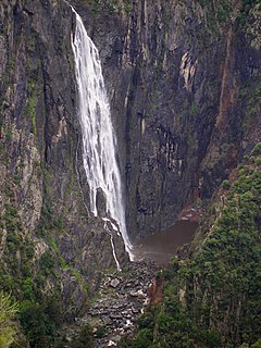
The Wollomombi Falls is a plunge waterfall on the Wollomombi River in the New England region of New South Wales, Australia.

Mount Canobolas, a mountain on a spur of the Great Dividing Range, is located in the Central Tablelands region of New South Wales, Australia.
The New South Wales Office of Environment and Heritage (OEH), a former division of the Government of New South Wales between April 2011 and July 2019, was responsible for the care and protection of the environment and heritage, which includes the natural environment, Aboriginal country, culture and heritage, and built heritage in New South Wales, Australia. Until its abolition in 2019, the OEH supported the community, business and government in protecting, strengthening and making the most of a healthy environment and economy within the state. The OEH was part of the Department of Planning and Environment cluster and managed national parks and reserves.

Rocky Creek Dam is a minor rock fill clay core embankment dam across the Rocky Creek, located upstream of Lismore in the Northern Rivers region of New South Wales, Australia. The dam's main purpose is to supply potable water for the region, including Lismore, Ballina, Byron Bay, Evans Head and Alstonville. The impounded reservoir is called Rocky Lake.

Fitzroy Falls is a village in the Wingecarribee Shire, located within the Southern Highlands region of New South Wales, Australia. The locality was known as Yarrunga, but was renamed after the 81-metre (266 ft) waterfall. At the 2016 census, Fitzroy Falls had a population of 216.
Guy Fawkes River, a perennial stream that is part of the Clarence River catchment, is in the New England and Northern Tablelands districts of New South Wales, Australia.

Aberfoyle River, a watercourse that is part of the Clarence River catchment, is located in the New England and Northern Tablelands districts of New South Wales, Australia.
Boyd River, a perennial stream that is part of the Clarence River catchment, is located in the Northern Tablelands district of New South Wales, Australia.

The Wilsons Peak Flora Reserve is a protected nature reserve that is located in the Northern Rivers region in the state of New South Wales, in eastern Australia. The reserve is bounded to the north by the border between New South Wales and the state of Queensland. The nearest town is the Queensland settlement of Killarney.

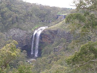
The Minyon Falls is a plunge waterfall on the Repentance Creek in the Northern Rivers region of New South Wales, Australia. The waterfall descends more than 100 metres (330 ft) over the huge rhyolite cliffs which were once part of the Tweed Volcano. The water flow eroded the underlying basalt away to create the waterfall.
Brumlow Top is a mountain on the Barrington Tops plateau, in the Mid-Coast Council in New South Wales, Australia.

Polblue is a mountain on the Barrington Tops plateau, located in the Mid-Coast Council within New South Wales, Australia.
The Chandlers Creek, a perennial stream that is part of the Clarence River catchment, is located in the Northern Tablelands region of New South Wales, Australia.

The Berowra Valley National Park is a protected national park that is located in northern Sydney, New South Wales, Australia. The 3,884-hectare (9,600-acre) national park is situated approximately 20 kilometres (12 mi) north-west of the Sydney central business district. Located within the Sydney Basin, the park is part of the dissected Hornsby Plateau which is dominated by Hawkesbury Sandstone and predominately covers the catchment area of Berowra Creek.
The Nightcap Range is a mountain range located in the Northern Rivers region of New South Wales, Australia. The range is a spur off the Great Dividing Range and extends generally southeast from Mount Burrell for about 25 kilometres (16 mi) to Peates Mountain. It is separated from the remainder of the Great Dividing Range by the Nimbin Gap. The Range forms the southern flank of the Mount Warning (Tweed) shield volcano and geologically, is formed from the Lismore Basalts which are then overlain successively by the Nimbin Rhyolites and finally the Blue Knob Basalts.

The Caloola Club was a bushwalking and outdoors activity club that was based in Sydney, New South Wales, Australia, founded in 1945 and active until 1963 when it merged with the National Parks Association of N.S.W.

Limeburners Creek National Park is a protected national park on the Mid North Coast of New South Wales, Australia. The 91.2km national park is located 5 km (3.1 mi) to the north of Port Macquarie and exists across both the Kempsey Shire and Port Macquarie-Hastings Council local government areas, but is chiefly managed by National Parks and Wildlife Service. The area was originally erected as a nature reserve but this reservation was revoked when it became formally recognised as a national park in 2010 under the National Parks and Wildlife Act (1974). Many threatened ecological habitats and species of fauna and flora are found within this park, alongside several heritage sites of cultural significance, particularly to the local Birpai and Dunghutti people upon whose land the park exists. The protected status of this national park is largely owing to the ecological and cultural value of the area, in addition to the value of the ecosystems to further scientific research.

