Related Research Articles

King Salmon Airport is a state-owned public-use airport located just southeast of King Salmon, in the Bristol Bay Borough of the U.S. state of Alaska. It was formerly the Naknek Air Force Base, named for its location near the Naknek River.

Nome Airport is a state-owned public-use airport located two nautical miles (4 km) west of the central business district of Nome, a city in the Nome Census Area of the U.S. state of Alaska.
Rostraver Airport is a public use airport in Westmoreland County, Pennsylvania, United States.

Cartersville Airport, Valley of Pumpkinvine Creek Field, is a public use airport located on a small hill by the Etowah River two nautical miles (4km) west of the headwaters of Pumpkinvine Creek and three nautical miles (6 km) southwest of the central business district of Cartersville, in Bartow County, Georgia, United States. It is owned by the Cartersville Bartow Airport Authority.
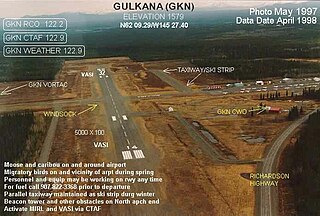
Gulkana Airport is a state owned, public use airport located four nautical miles northeast of the central business district of Gulkana, in the Valdez-Cordova Census Area of the U.S. state of Alaska. It is also and five miles (8 km) northeast of Glenallen. Scheduled passenger service is subsidized by the Essential Air Service program.
W. K. Kellogg Airport is a city-owned, public-use, joint civil-military airport located three nautical miles (6 km) west of the central business district of Battle Creek, a city in Calhoun County, Michigan, United States. The airport is accessible by road from Helmer Road, and is located near I-94. It is included in the Federal Aviation Administration (FAA) National Plan of Integrated Airport Systems for 2017–2021, in which it is categorized as a regional general aviation facility. It is also known as W. K. Kellogg Regional Airport.

Monroe County Airport is a county-owned public-use airport located three nautical miles (6 km) south of the central business district of Monroeville, in Monroe County, Alabama, United States. According to the FAA's National Plan of Integrated Airport Systems for 2009–2013, it is categorized as a general aviation facility.

Prineville Airport is a public use airport located three nautical miles southwest of the central business district of Prineville, in Crook County, Oregon, United States. According to the FAA's National Plan of Integrated Airport Systems for 2009–2013, it is classified as a general aviation airport.
Scappoose Airport is a public use airport located one nautical mile (1.85 km) northeast of the central business district of Scappoose, in Columbia County, Oregon, United States. It is owned and operated by the Port of Columbia County, an Oregon port district and municipal corporation, on behalf of district residents. According to the FAA's National Plan of Integrated Airport Systems for 2009–2013, it is categorized as a general aviation airport.
Elkhart Municipal Airport is a city-owned public-use airport located three nautical miles (6 km) northwest of the central business district of Elkhart, a city in Elkhart County, Indiana, United States.
Eagle Creek Airpark is a public use airport located seven nautical miles (13 km) west of the central business district of Indianapolis, a city in Marion County, Indiana, United States. It is owned by the Indianapolis Airport Authority and serves as a reliever airport for Indianapolis International Airport.
Monticello Municipal Airport, also known as Ellis Field, is a public-use airport located two nautical miles east of the central business district of Monticello, in Drew County, Arkansas, United States. It is owned by the City of Monticello.
Fremont Municipal Airport is a city-owned public-use airport located three nautical miles (6 km) southwest of the central business district of Fremont, a city in Newaygo County, Michigan, United States. The airport is uncontrolled, and is used for general aviation purposes. Skydiving and ultralight activity are also conducted at the field. It is included in the Federal Aviation Administration (FAA) National Plan of Integrated Airport Systems for 2017–2021, in which it is categorized as a local general aviation facility.

Scottsboro Municipal Airport, also known as Word Field, is a city-owned public-use airport located two nautical miles (3.7 km) northeast of the central business district of Scottsboro, a city in Jackson County, Alabama, United States. According to the FAA's National Plan of Integrated Airport Systems for 2009–2013, it is categorized as a general aviation facility.
Miami Homestead General Aviation Airport is a county-owned public-use airport in unincorporated Miami-Dade County, Florida, United States, located 4 miles (6.4 km) northwest of the central business district of Homestead.

Bentonville Municipal Airport is a city-owned, public-use airport located two nautical miles (3.7 km) south of the central business district of Bentonville, a city in Benton County, Arkansas, United States. It is also known as Louise M. Thaden Field or Louise Thaden Field, a name it was given in 1951 to honor Louise McPhetridge Thaden (1905–1979), an aviation pioneer from Bentonville.
Owosso Community Airport is a public-use airport located in Caledonia Charter Township, two miles (3 km) east of Owosso, between the cities of Owosso and Corunna, in Shiawassee County, Michigan, United States. It is owned by the Shiawassee Airport Board, a multi-government authority with five voting members from Shiawassee County, the cities of Owosso and Corunna, and the townships of Owosso and Caledonia. It is included in the Federal Aviation Administration (FAA) National Plan of Integrated Airport Systems for 2017–2021, in which it is categorized as a local general aviation facility.
Hastings Airport is a public use airport located three nautical miles (6 km) west of the central business district of Hastings, a city in Barry County, Michigan, United States. It is owned by the city and county and is also known as Hastings City/Barry County Airport.
Lost Creek Airport is a public use airport located three nautical miles (6 km) northeast of the central business district of Luzerne, in Oscoda County, Michigan, United States. It is owned by the U.S. Department of Agriculture.
Heritage Creek Airstrip is a privately owned public airport in Rhome, Wise County, Texas, United States, that also serves the city of Decatur, being located approximately 9 nautical miles (17 km) southeast of the central business district. The airport has no IATA or ICAO designation.