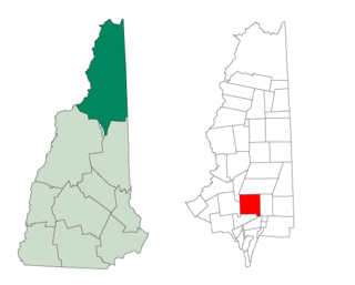
Randolph is a heavily forested town in Coös County, New Hampshire, United States, extending from the northern slopes of the White Mountains of the Presidential Range to the Crescent Range and Berlin, with U.S. Route 2 cutting through the middle. The northern and southern parts of Randolph are within the White Mountain National Forest and the Ice Gulch Town Forest, while the central part is the settled portion of town. As of the 2020 census, the town had a population of 328.

The White Mountains are a mountain range covering about a quarter of the state of New Hampshire and a small portion of western Maine in the United States. They are a subrange of the northern Appalachian Mountains and the most rugged mountains in New England. Several of the higher peaks contain an Alpine tundra. The range is heavily visited due to its proximity to Boston, New York City, and Montreal.

The Black Rock Desert is a semi-arid region of lava beds and playa, or alkali flats, situated in the Black Rock Desert–High Rock Canyon Emigrant Trails National Conservation Area, a silt playa 100 miles (160 km) north of Reno, Nevada, that encompasses more than 300,000 acres (120,000 ha) of land and contains more than 120 miles (200 km) of historic trails. It is in the northern Nevada section of the Great Basin with a lakebed that is a dry remnant of Pleistocene Lake Lahontan.

The Santa Monica Mountains are a coastal mountain range in Southern California, next to the Pacific Ocean. It is part of the Transverse Ranges. The Santa Monica Mountains National Recreation Area encompasses this mountain range. Because of its proximity to densely populated regions, it is one of the most visited natural areas in California.

The Teton Range is a mountain range of the Rocky Mountains in North America. It extends for approximately 40 miles (64 km) in a north–south direction through the U.S. state of Wyoming, east of the Idaho state line. It is south of Yellowstone National Park, and most of the east side of the range is within Grand Teton National Park.

The Inyo Mountains are a short mountain range east of the Sierra Nevada in eastern California in the United States. The range separates the Owens Valley to the west from Saline Valley to the east, extending for approximately 70 miles (110 km) south-southeast from the southern end of the White Mountains, from which they are separated by Westgard Pass, to the east of Owens Lake.
The Selkirk Mountains are a mountain range spanning the northern portion of the Idaho Panhandle, eastern Washington, and southeastern British Columbia which are part of a larger grouping of mountains, the Columbia Mountains. They begin at Mica Peak and Krell Hill near Spokane and extend approximately 320 km north from the border to Kinbasket Lake, at the now-deserted location of the onetime fur company post, Boat Encampment. The range is bounded on its west, northeast and at its northern extremity by the Columbia River, or the reservoir lakes now filling most of that river's course. From the Columbia's confluence with the Beaver River, they are bounded on their east by the Purcell Trench, which contains the Beaver River, Duncan River, Duncan Lake, Kootenay Lake and the Kootenay River. The Selkirks are distinct from, and geologically older than, the Rocky Mountains. The neighboring Monashee and Purcell Mountains, and sometimes including the Cariboo Mountains to the northwest, are also part of the larger grouping of mountains known as the Columbia Mountains. A scenic highway loop, the International Selkirk Loop, encircles the southern portions of the mountain range.

The Diablo Range is a mountain range in the California Coast Ranges subdivision of the Pacific Coast Ranges in northern California, United States. It stretches from the eastern San Francisco Bay Area at its northern end to the Salinas Valley area at its southern end.

The Hudson Highlands are mountains on both sides of the Hudson River in New York state lying primarily in Putnam County on its east bank and Orange County on its west. They continue somewhat to the south in Westchester County and Rockland County, respectively. The highlands are a subrange of the Appalachian Mountains.
Foundation Ice Stream is a major ice stream in the Pensacola Mountains of Antarctica. The ice stream drains northward for 150 nautical miles along the west side of the Patuxent Range and the Neptune Range to enter the Ronne Ice Shelf westward of Dufek Massif.

Black Hills National Forest is located in southwestern South Dakota and northeastern Wyoming, United States. The forest has an area of over 1.25 million acres (5,066 km2) and is managed by the Forest Service. Forest headquarters are located in Custer, South Dakota. There are local ranger district offices in Custer, Rapid City, and Spearfish in South Dakota, and in Sundance, Wyoming.

The Chemehuevi Mountains are a mountain range that are found at the southeast border of San Bernardino County in southeastern California and are adjacent the Colorado River. Located south of Needles, California and northwest of the Whipple Mountains, the mountains are oriented in a north–south direction, and stretch for approximately 15 miles (24 km) in length.
The Sør Rondane Mountains are a group of mountains about 100 miles (160 km) long with main peaks rising to 3400 m, between the Queen Fabiola Mountains and Wohlthat Mountains in Queen Maud Land. They were discovered and photographed from the air by members of the Lars Christensen Expedition (LCE) on February 6, 1937, and named after Rondane, a mountain massif in southern Norway. The mountains and their constituent features were mapped in greater detail and named in 1957 by Norwegian cartographers working with air photos taken by U.S. Navy Operation Highjump, 1946–47.
The Chalk Hills are a north–south-running low 'mountain' range in the San Fernando Valley perpendicular to and adjoining the Santa Monica Mountains. They are located in the Woodland Hills District of the City of Los Angeles in Southern California. They run between DeSoto and Winnetka Avenues, from south of Ventura Boulevard north to near Victory Boulevard.

The Arizona/New Mexico Mountains ecoregion is a Level III ecoregion designated by the United States Environmental Protection Agency (EPA) in the U.S. states of Arizona and New Mexico.

