
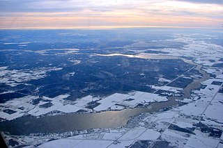
Lake Winnipeg is a very large, relatively shallow 24,514-square-kilometre (9,465 sq mi) lake in North America, in the province of Manitoba, Canada. Its southern end is about 55 kilometres (34 mi) north of the city of Winnipeg. Lake Winnipeg is Canada's sixth-largest freshwater lake and the third-largest freshwater lake contained entirely within Canada, but it is relatively shallow excluding a narrow 36 m (118 ft) deep channel between the northern and southern basins. It is the eleventh-largest freshwater lake on Earth. The lake's east side has pristine boreal forests and rivers that were in 2018 inscribed as Pimachiowin Aki, a UNESCO World Heritage Site. The lake is 416 km (258 mi) from north to south, with remote sandy beaches, large limestone cliffs, and many bat caves in some areas. Manitoba Hydro uses the lake as one of the largest reservoirs in the world. There are many islands, most of them undeveloped.

The Saskatchewan River is a major river in Canada. It stretches about 550 kilometres (340 mi) from where it is formed by the joining together of the North Saskatchewan and South Saskatchewan Rivers to Lake Winnipeg. It flows roughly eastward across Saskatchewan and Manitoba to empty into Lake Winnipeg. Through its tributaries the North Saskatchewan and South Saskatchewan, its watershed encompasses much of the prairie regions of Canada, stretching westward to the Rocky Mountains in Alberta and north-western Montana in the United States.

The South Saskatchewan River is a major river in the Canadian provinces of Alberta and Saskatchewan. The river begins at the confluence of the Bow and Oldman Rivers in southern Alberta and ends at the Saskatchewan River Forks in central Saskatchewan. The Saskatchewan River Forks is the confluence of the South and North Saskatchewan Rivers and is the beginning of the Saskatchewan River.
The Winnipeg River is a Canadian river that flows roughly northwest from Lake of the Woods in the province of Ontario to Lake Winnipeg in Manitoba. This river is 235 kilometres (146 mi) long from the Norman Dam in Kenora to its mouth at Lake Winnipeg. Its watershed is 106,500 square kilometres (41,100 sq mi) in area, mainly in Canada. About 29,000 square kilometres (11,000 sq mi) of the watershed is in northern Minnesota, United States.

The Churchill River is a major river in Alberta, Saskatchewan and Manitoba, Canada. From the head of the Churchill Lake it is 1,609 kilometres (1,000 mi) long. It was named after John Churchill, 1st Duke of Marlborough and governor of the Hudson's Bay Company from 1685 to 1691.
The Fond du Lac River is one of the upper branches of the Mackenzie River system, draining into the Arctic Ocean, located in northern Saskatchewan, Canada. The river is 277 kilometres (172 mi) long, has a watershed of 66,800 square kilometres (25,800 sq mi), and its mean discharge is 300 cubic metres per second (11,000 cu ft/s).

The history of post-confederation Canada began on July 1, 1867, when the British North American colonies of Canada, New Brunswick, and Nova Scotia were united to form a single Dominion within the British Empire. Upon Confederation, the United Province of Canada was immediately split into the provinces of Ontario and Quebec. The colonies of Prince Edward Island and British Columbia joined shortly after, and Canada acquired the vast expanse of the continent controlled by the Hudson's Bay Company, which was eventually divided into new territories and provinces. Canada evolved into a fully sovereign state by 1982.
The Berens River is a river in the provinces of Manitoba and Ontario, Canada. It flows west from an unnamed lake in Kenora District, Ontario, and discharges its waters into Lake Winnipeg near the community and First Nation of Berens River, Manitoba. The river has a number of lakes along its course, and many rapids.
The Whitefish River is a 45 km (28 mi) long river in Thunder Bay District in northwestern Ontario, Canada. It is in the Lake Superior drainage basin, is a tributary of the Kaministiquia River, and is in the centre of the Whitefish River Valley which is the location of several small settlements that grew along the Port Arthur, Duluth and Western Railway.

The Whitefish River is a river in Sudbury District in northeastern Ontario, Canada and a tributary of Lake Huron.
The Whitefish River is a river in the James Bay and Moose River drainage basins in Cochrane and Timiskaming Districts in northeastern Ontario, Canada. It flows 75 kilometres (47 mi) from Mount Sinclair Lake to its mouth at Night Hawk Lake, the source of the Frederick House River, a tributary of the Abitibi River.
The Whitefish River is a river in Kenora District in northwestern Ontario, Canada. It is in the Hudson Bay and Nelson River drainage basins and is a tributary of the Berens River.
The Whitefish River is a short river in Kenora District in northwestern Ontario, Canada, and is in the Hudson Bay and Nelson River drainage basins.

Minago River is a river in the Hudson Bay drainage basin in Northern Manitoba, Canada. It flows in a northeasterly direction from Moon Lake into the western end of Cross Lake on the Nelson River.

Nesosap Lake is a glacial lake on the Mistik Creek chain, approximately 21 kilometres (13 mi) northeast of Bakers Narrows. As a segment of the Mistik Creek, it is part of the Nelson River watershed, in the Hudson Bay drainage basin in the Northern Region of Manitoba, Canada.
Naosap Lake is a glacial lake in Canada, located approximately 28 kilometres (17 mi) northeast of Bakers Narrows, Manitoba. As the source of the Mistik Creek, it is part of the Nelson River watershed, in the Hudson Bay drainage basin in the Northern Region of Manitoba.
Alberts Lake is a glacial lake approximately 17 km (11 mi) north-east of Bakers Narrows which drains into Thompson Lake. It is part of the Nelson River watershed, in the Hudson Bay drainage basin in Northern Manitoba, Canada.

The Grass River is a historically important waterway in the Hudson Bay drainage basin in the Northern Region of Manitoba, Canada. It begins at the Cranberry Lakes approximately 27 kilometres (17 mi) east of Cranberry Portage and runs northeast 500 kilometres (310 mi) to its mouth on the Nelson River. The river was a critical route for earlier European explorers and was part of the "Upper Tract" of the fur trade into Canadian interior.
Woody River is a river in the Canadian provinces of Manitoba and Saskatchewan. The river's source is in the Porcupine Hills and Porcupine Provincial Forest of eastern Saskatchewan. From there it flows south through boreal forest and then east through Boreal Plains in the Parkland Region of Manitoba en route to Swan Lake. The river parallels the Swan River for much of its route as it travels through Swan River Valley between Duck Mountain and Porcupine Hills of the Manitoba Escarpment. Bowsman is the only notable community along the course of Woody River. Several highways cross it, including Saskatchewan's Highway 980, Manitoba's Roads 588, 587, 366, 268, and Manitoba's Highway 10.
Whitefish Lake is a lake in the Canadian province of Manitoba. It is located on the western side of the province immediately east of the border with Saskatchewan in the Porcupine Hills of the Manitoba Escarpment. The lake is in Manitoba's Porcupine Provincial Forest, which is a boreal forest. Accessed is on the east side from Provincial Road 279.
