Whitewater recreation in British Columbia

Last updated

Whitewater recreation in British Columbia is available in most of the province. Except for north-central and northeast British Columbia, the province is mostly mountainous with many glacial fed rivers draining though steep terrain creating excellent whitewater. Most commercial whitewater operations in British Columbia are rafting outfitters. However the provinces rivers are also well known to be good for whitewater kayaking, whitewater canoeing and river surfing (in select spots) although these activities are often done unguided.

Contents

Commercially Guided Whitewater Rivers

British Columbia has many commercially rafted whitewater rivers ranging from half day float trips to week-long wilderness expeditions though raging Class 5 Rapids. Only the most notable are mentioned below.

Fraser River

Hells Gate Fraser River - Hells Gate - panoramio.jpg
Hells Gate

The Fraser River is the largest un-dammed whitewater river in North America with an average flow rate of 3,475m3/s. [1] The river has a steep gradient in a 270 kilometre long Fraser Canyon forming major rapids rated up to Class 5. Major named rapids include Hells Gate and the Bridge River Rapids. Due to its high flows, scenic canyon and numerous rapids it represents the pinnacle of whitewater rafting and kayaking in British Columbia and is one of the largest commercially rafted rivers in the world. Several outfitters and rafting companies run tours on the Fraser River. [2]

Thompson River

Rapids on the Thompson River Avalanche Alley (5999035523).jpg
Rapids on the Thompson River

The Thompson River is a major tributary of the Fraser River and features rapids and canyon scenery similar to the Fraser but on a smaller scale. While it is a slightly lower difficulty than the Fraser due to its lower water volume, its whitewater is considered among the best in British Columbia. Due to its slightly easier rapids it sees more commercial rafting than the Fraser. Some runs start on the Thompson River and continue down the Fraser after the Thompson merges with it in Lytton. [2]

Chilcotin and Chilko Rivers

The Chilcotin River is a midsized tributary of the Fraser which along with its main tributary the Chilko River contain notable whitewater. The two rivers travel largely though wilderness and the running them both takes multiple days. Trips on these rivers often include the Fraser as well after they merge. A few outfitters offer theses rivers as a weeklong rafting trip. [2]

Clearwater River

The Clearwater River is a midsized tributary of the North Thompson River (part of the Fraser River Drainage) located in central British Columbia. This river's watershed is mostly located in Wells Gray Provincial Park a popular camping destination. Due to the geology of the area the river contain's numerous whitewater features including several waterfalls and major rapids. A section of the river near the downstream end of the Park is very popular for commercial rafting day trips mostly organized from the nearby town of Clearwater. The largest rapids on this section are Class 4. Other sections of the river contain large waterfalls and rapids up to Class 6 and are only suitable for expert whitewater kayakers. The lower section of this river also contains several features that are good for river surfing. [3]

Kicking Horse River

Kicking Horse River Kicking Horse River.jpg
Kicking Horse River

The Kicking Horse River is a small tributary of the Columbia River located in eastern British Columbia near the town of Golden. Due to its location along the Trans Canada Highway the area sees significant tourism including numerous day rafting outfitters. Only the section of the river below Wapta Falls is commercially run. [2]

Chilliwack River

The Chilliwack River is a small tributary of the Fraser River located in the Lower Mainland of British Columbia. Due to its proximity to Vancouver and moderate whitewater it is frequently run by both guided and un guided rafters and kayakers. In late summer and fall the river goes almost dry and cannot be run. [2]

Tatshenshini and Alsek Rivers

Rafting on the Alsek River Confluence of Alsek and Tatshenshini rivers2.JPG
Rafting on the Alsek River

This Alsek River system is located in the extreme north west corner of British Columbia and flows into Alaska. It unique scenery and significant rapids. In several locations glaciers feed directly into the river and rafts can paddle on lakes next to icebergs. Being located in an extremely remote area only week long expeditions are possible with a fly in and out required. Despite the remoteness, several outfitters operate on this river. [4] The Turnback Canyon section is never run by commercial rafting outfitters and has only been conquered by a handful of world class whitewater kayakers.

Other Notable Whitewater Rivers

Stikine River

The Stikine River's Grand Canyon of the Stikine run is known for being one of the most difficult whitewater descents in the world. Officially considered unnavigable by B.C. parks, it has been run by only a handful of the most experienced whitewater enthusiasts, almost always with air support. The canyon is extremely deep, preventing any chance for kayaker to bail out mid trip. Despite being a decently large river the Stikine squeezes through surging chutes only a meter wide, the descent also includes several small waterfalls. [5] [6]

Liard River

Located in the northern wilderness near the border of the Yukon Territory, the Liard River is British Columbia's second largest un-dammed river and contains a half dozen monstrous Class 5+ rapids in the Grand Canyon of the Liard, the largest of which are the Class 6 Hells Gate (not to be confused with the rapid of the same name on the Fraser River) and The Rapids of the Drowned. Despite being one of the largest and most powerful whitewater rivers in the world the Liard receives very little attention in the present due to the canyon's remote location and the rapids being far too large for safe commercial rafting operations. Liard River Corridor Provincial Park and Protected Area was established in 1999 to prevent the rapids from being harnessed for hydroelectric power. [7]

Tidal Rapids

Skookumchuck Narrows is the only well known and easily accessible tidal rapid in British Columbia; it is located on the Sunshine Coast near the village of Earls Cove. They can range in strength from Class 5 to flat-water depending on the tide at the time of visitation. Some local operators offer tours through the rapids in Zodiacs (but only when they are less than half their peak strength) but most of the visitation is from solo whitewater kayakers and surfers. [8]

Skookumchuck Narrows Skookumchuck 2013.jpg
Skookumchuck Narrows

Related Research Articles

<span class="mw-page-title-main">Rafting</span> Recreational outdoor activity

Rafting and whitewater rafting are recreational outdoor activities which use an inflatable raft to navigate a river or other body of water. This is often done on whitewater or different degrees of rough water. Dealing with risk is often a part of the experience.

<span class="mw-page-title-main">Bruneau River</span> River in Idaho and Nevada, United States

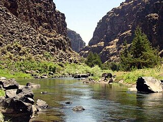
The Bruneau River is a 153-mile-long (246 km) tributary of the Snake River, in the U.S. states of Idaho and Nevada. It runs through a narrow canyon cut into ancient lava flows in southwestern Idaho. The Bruneau Canyon, which is up to 1,200 feet (370 m) deep and 40 miles (64 km) long, features rapids and hot springs, making it a popular whitewater trip.

<span class="mw-page-title-main">Lehigh River</span> River in Pennsylvania, United States

The Lehigh River is a 109-mile-long (175 km) tributary of the Delaware River in eastern Pennsylvania. The river flows in a generally southward pattern from the Pocono Mountains in Northeastern Pennsylvania through Allentown and much of the Lehigh Valley before joining the Delaware River in Easton.

<span class="mw-page-title-main">Stikine River</span> River in British Columbia and Alaska

The Stikine River is a major river in northern British Columbia (BC), Canada and southeastern Alaska in the United States. It drains a large, remote upland area known as the Stikine Country east of the Coast Mountains. Flowing west and south for 610 kilometres (379 mi), it empties into various straits of the Inside Passage near Wrangell, Alaska. About 90 percent of the river's length and 95 percent of its drainage basin are in Canada. Considered one of the last truly wild large rivers in BC, the Stikine flows through a variety of landscapes including boreal forest, steep canyons and wide glacial valleys.

<span class="mw-page-title-main">Watauga River</span> River in the United States of America

The Watauga River is a large stream of western North Carolina and East Tennessee. It is 78.5 miles (126.3 km) long with its headwaters in Linville Gap to the South Fork Holston River at Boone Lake.

<span class="mw-page-title-main">Thompson River</span> River in British Columbia, Canada

The Thompson River is the largest tributary of the Fraser River, flowing through the south-central portion of British Columbia, Canada. The Thompson River has two main branches, the South Thompson River and the North Thompson River. The river is home to several varieties of Pacific salmon and trout. The area's geological history was heavily influenced by glaciation, and the several large glacial lakes have filled the river valley over the last 12,000 years. Archaeological evidence shows human habitation in the watershed dating back at least 8,300 years. The Thompson was named by Fraser River explorer, Simon Fraser, in honour of his friend, Columbia Basin explorer David Thompson. Recreational use of the river includes whitewater rafting and angling.

<span class="mw-page-title-main">Kicking Horse River</span> River in British Columbia, Canada

The Kicking Horse River is in the Canadian Rockies of southeastern British Columbia, Canada. The river was named in 1858, when James Hector, a member of the Palliser Expedition, reported being kicked by his packhorse while exploring the river. Hector named the river and the associated pass as a result of the incident. The Kicking Horse Pass, which connects through the Rockies to the valley of the Bow River, was the route through the mountains subsequently taken by the Canadian Pacific Railway when it was constructed during the 1880s. The railway's Big Hill and associated Spiral Tunnels are in the Kicking Horse valley and were necessitated by the steep rate of descent of the river and its valley.

<span class="mw-page-title-main">Afon Tryweryn</span> River in the United Kingdom

The Tryweryn is a river in the north of Wales which starts at Llyn Tryweryn in the Snowdonia National Park and after 19 kilometres (12 mi) joins the river Dee at Bala. One of the main tributaries of the Dee, it was dammed in 1965 to form Llyn Celyn. The Tryweryn flooding forcibly removed residents of the village of Capel Celyn despite popular and political opposition in Wales. The resulting graffiti "Cofiwch Dryweryn" near Llanrhystud became and remains a popular icon of Welsh feeling. Water is stored in Llyn Celyn in winter when flows are high, and released over the summer to maintain the flow in the Dee (water from the Dee is used as the water supply for large areas of north-east Wales, and for the Wirral and much of Liverpool in England.

<span class="mw-page-title-main">Alsek River</span> River in Yukon Territory, British Columbia, and Alaska

The Alsek River is a wilderness river flowing from Yukon into Northern British Columbia and into Alaska. It enters the Gulf of Alaska at Dry Bay.

<span class="mw-page-title-main">Chattooga River</span> River in the Southeastern USA

The Chattooga River is the main tributary of the Tugaloo River.

<span class="mw-page-title-main">Gore Canyon</span> Landform in Grand County, Colorado

Gore Canyon, elevation 6,985 feet (2,129 m), is a short isolated canyon on the upper Colorado River in southwestern Grand County, Colorado in the United States. Steep and rugged, the approximately 3-mile-long (4.8 km) gorge was carved by the river as it passed the northern end of the Gore Range southwest of Kremmling. The Colorado descends from approximately 7,300 ft (2,200 m) to approximately 7,000 ft (2,100 m) over the length of the canyon. The steep walls ascend approximately 1,000 ft (300 m) on either side. The canyon effectively marks the southwestern end of the Middle Park basin in north-central Colorado.

<span class="mw-page-title-main">Nantahala River</span> Stream in North Carolina, USA

The Nantahala River is a river in western North Carolina in the United States, within the Nantahala National Forest, and near the Great Smoky Mountains National Park. Two-lane U.S. Highway 19/74 runs along the river, picnic areas dotting the route. In 1839, this was an unimproved large path, part of what became known as the Trail of Tears as the Cherokee people were forcibly removed from their homelands in this region to west of the Mississippi River and Indian Territory.

<span class="mw-page-title-main">Jarbidge River</span> River in Nevada and Idaho, United States

The Jarbidge River is a 51.8-mile-long (83.4 km), high elevation river in Elko County, Nevada and Owyhee County, Idaho in the United States. The Jarbidge originates as two main forks in the Jarbidge Mountains of northeastern Nevada and then flows through basalt and rhyolite canyons on the high plateau of the Owyhee Desert before joining the Bruneau River.

<span class="mw-page-title-main">Pacuare River</span> River in Costa Rica

The Pacuare River, or the Río Pacuare, in Costa Rica has its source in the Cordillera de Talamanca and flows approximately 108 kilometres (67 mi) to the Caribbean. It is a popular location for white water rafting, whitewater kayaking and riverboarding. The rainforests that surround the river are home to exotic animal species such as jaguars, monkeys, ocelots, and a very large number of birds. It was considered one of the 5 nicest rivers to practice rafting.

<span class="mw-page-title-main">Clearwater River (British Columbia)</span> River in British Columbia, Canada

The Clearwater River is the largest tributary of the North Thompson River, joining it at the community of Clearwater, British Columbia. The Clearwater rises from glaciers in the Cariboo Mountains and flows in a mostly southerly direction for 201 km (125 mi) to the North Thompson. Its entire course, except the last 5 km (3 mi), is within Wells Gray Provincial Park. Its confluence with the North Thompson is protected by North Thompson River Provincial Park.

<span class="mw-page-title-main">Stikine Country</span> Geographic region of British Columbia, Canada

The Stikine Country, also referred to as the Stikine District or simply "the Stikine", is one of the historical geographic regions of the Canadian province of British Columbia, located inland from the central Alaska Panhandle and comprising the basin of the Stikine River and its tributaries. The term Stikine–Iskut is also fairly common to describe the area, and references the Iskut River, the Stikine's largest tributary and describable as its south fork.

<span class="mw-page-title-main">Bee Cliff (Tennessee)</span>

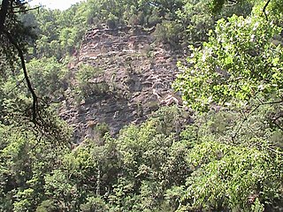
The Bee Cliff is a prominent northeast Tennessee geological limestone feature with high caves that overlooks the Watauga River and the Siam community of Carter County, Tennessee.

<span class="mw-page-title-main">Grand Canyon of the Stikine</span> Steep-sided canyon carved by the Stikine River in British Columbia, Canada

The Grand Canyon of the Stikine is a 72 km (45 mi) stretch of the Stikine River in northern British Columbia, Canada. It has been compared to the Grand Canyon of the Colorado. The canyon is home to a large population of mountain goats and other wildlife. Officially the canyon is described as unnavigable by any watercraft, however there have been numerous successful descents made by expert whitewater paddlers since the first attempt in 1981. Since it was first attempted, the Grand Canyon of the Stikine has maintained a legendary reputation among whitewater experts as the 'Mt. Everest' of big water expedition whitewater boating against which all other navigable rivers are measured.

<span class="mw-page-title-main">Cataract Canyon</span> Section of the Colorado River

Cataract Canyon is a 46-mile-long (74 km) canyon of the Colorado River located within Canyonlands National Park and Glen Canyon National Recreation Area in southern Utah. It begins at Colorado's confluence with the Green River, and its downstream terminus is the confluence with the Dirty Devil River. The lower half of the canyon is submerged beneath Lake Powell when the lake is at its normal high water elevation of 3,700 feet (1,100 m).

References

  1. "Real-Time Hydrometric Data Map Search - Water Level and Flow - Environment Canada". wateroffice.ec.gc.ca. Retrieved 2023-05-17.
  2. 1 2 3 4 5 "BCROA Members - Search Our Qualified Members Across BC". 2021-09-10. Retrieved 2023-05-17.
  3. Neave, Ronald (2023). Exploring Wells Gray Park (7th ed.). Kamloops B.C.: Wells Gray Tours. ISBN   978-0-9681932-3-5.
  4. Parks Canada Agency, Government of Canada (2022-12-21). "Rafting the Alsek River". parks.canada.ca. Retrieved 2023-05-17.
  5. "A Short History of the Grand Canyon of the Stikine River". 2009-03-28. Archived from the original on 2009-03-28. Retrieved 2023-05-17.
  6. "30 Years: Grand Canyon of the Stikine - Canoe & Kayak". 2014-10-06. Archived from the original on 2014-10-06. Retrieved 2023-05-17.
  7. "Liard River Corridor Park". BC Parks. Retrieved 2023-05-17.
  8. "Skookumchuck Narrows | Things to Do | Sunshine Coast Tourism". www.sunshinecoastcanada.com. Retrieved 2023-05-17.