Wichita Falls Municipal Airport

Last updated
Wichita Falls Regional Airport

Sheppard Air Force Base
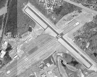
Sheppardafb.jpg
Summary
Airport typePublic / Military
Owner U.S. Air Force
OperatorCity of Wichita Falls
Location Wichita Falls, Texas
Elevation  AMSL 1,019 ft / 311 m
Coordinates 33°59′20″N098°29′31″W / 33.98889°N 98.49194°W / 33.98889; -98.49194 Coordinates: 33°59′20″N098°29′31″W / 33.98889°N 98.49194°W / 33.98889; -98.49194
Website FlyWichitaFalls.net
Map
Relief map of Texas.png
Airplane silhouette.svg
SPS
Location
Runways
Direction LengthSurface
ftm
15R/33L13,1003,993Concrete
15C/33C10,0023,049Asphalt/Concrete
15L/33R6,0001,829Asphalt/Concrete
17/357,0212,140Asphalt
Statistics (2017)
Aircraft operations228,672
Based aircraft210

Wichita Falls Regional Airport( IATA : SPS [2] , ICAO : KSPS, FAA LID : SPS) is a public and military use airport six miles north of Wichita Falls in Wichita County, Texas. [1] Its runways and taxiways are shared with Sheppard Air Force Base; most operations are military, but American Eagle flies to Dallas-Fort Worth International Airport.

An IATA airport code, also known as an IATA location identifier, IATA station code or simply a location identifier, is a three-letter code designating many airports around the world, defined by the International Air Transport Association (IATA). The characters prominently displayed on baggage tags attached at airport check-in desks are an example of a way these codes are used.

ICAO airport code four-letter code designating many airports around the world

The ICAOairport code or location indicator is a four-letter code designating aerodromes around the world. These codes, as defined by the International Civil Aviation Organization and published in ICAO Document 7910: Location Indicators, are used by air traffic control and airline operations such as flight planning.

Federal Aviation Administration United States Government agency dedicated to civil aviation matters

The Federal Aviation Administration (FAA) is a governmental body of the United States with powers to regulate all aspects of civil aviation in that nation as well as over its surrounding international waters. Its powers include the construction and operation of airports, air traffic management, the certification of personnel and aircraft, and the protection of U.S. assets during the launch or re-entry of commercial space vehicles. Powers over neighboring international waters were delegated to the FAA by authority of the International Civil Aviation Organization.

Contents

The National Plan of Integrated Airport Systems for 2011–2015 categorized it as a primary commercial service airport. [3] Federal Aviation Administration records say the airport had 47,191 passenger boardings (enplanements) in calendar year 2008, [4] 43,952 in 2009 and 44,296 in 2010. [5]

The National Plan of Integrated Airport Systems (NPIAS) is an inventory of U.S. aviation infrastructure assets. NPIAS was developed and now maintained by the Federal Aviation Administration (FAA).

The United States Federal Aviation Administration (FAA) has a system for categorizing public-use airports that is primarily based on the level of commercial passenger traffic through each facility. It is used to determine if an airport is eligible for funding through the federal government's Airport Improvement Program (AIP). Fewer than 20% of airports in the U.S. qualify for the program, though most that don't qualify are private-use-only airports.

Generally speaking, a calendar year begins on the New Year's Day of the given calendar system and ends on the day before the following New Year's Day, and thus consists of a whole number of days. A year can also be measured by starting on any other named day of the calendar, and ending on the day before this named day in the following year. This may be termed a "year's time", but not a "calendar year". To reconcile the calendar year with the astronomical cycle certain years contain extra days.

Facilities

The airport covers 3,800 acres (1,500 ha) at an elevation of 1,019 feet (311 m). It has four runways: [1]

Elevation Height of a geographic location above a fixed reference point

The elevation of a geographic location is its height above or below a fixed reference point, most commonly a reference geoid, a mathematical model of the Earth's sea level as an equipotential gravitational surface . The term elevation is mainly used when referring to points on the Earth's surface, while altitude or geopotential height is used for points above the surface, such as an aircraft in flight or a spacecraft in orbit, and depth is used for points below the surface.

Runway Area of surface used by aircraft to takeoff from and land on

According to the International Civil Aviation Organization (ICAO), a runway is a "defined rectangular area on a land aerodrome prepared for the landing and takeoff of aircraft". Runways may be a man-made surface or a natural surface.

In the year ending September 30, 2017 the airport had 228,672 aircraft operations, average 626 per day: 87% military, 10% general aviation, and 2% airline. 210 aircraft were then based at this airport: 200 military, 3 single-engine, 5 multi-engine, and 2 jet. [1]

General Aviation (GA) represents the 'private transport' and recreational flying component of aviation.

Airline and destination

AirlinesDestinations
American Eagle Dallas/Fort Worth

Related Research Articles

Northwest Arkansas Regional Airport airport

Northwest Arkansas Regional Airport is in Northwest Arkansas in Highfill, Arkansas, 15 nautical miles northwest of Fayetteville and 10 nautical miles northwest of Springdale. It is often referred to by its IATA code, which is incorporated in the airport's logo as "Fly XNA".

Lanai Airport commercial airport serving the island of Lanai, Hawaii, USA

Lanai Airport, also written as Lānaʻi Airport, is a state owned, public use airport located three nautical miles (6 km) southwest of the central business district of Lanai City, in Maui County, Hawaii. The airport began regular operations in 1930. It is the only airport serving the island of Lanai (Lānaʻi).

Bert Mooney Airport airport

Bert Mooney Airport is a public airport three miles southeast of Butte, in Silver Bow County, Montana. It is owned by the Bert Mooney Airport Authority.

Lawton–Fort Sill Regional Airport airport in Oklahoma, United States of America

Lawton–Fort Sill Regional Airport is two miles south of Lawton, in Comanche County, Oklahoma. It is used for military aviation from nearby Fort Sill and Sheppard Air Force Base and is served by American Eagle. Allegiant Air runs occasional charters.

Range Regional Airport airport in Hibbing, United States of America

Range Regional Airport is a public use airport located four nautical miles southeast of the central business district of Hibbing, in Saint Louis County, Minnesota, United States. It was formerly known as Chisholm-Hibbing Airport or Chisholm-Hibbing Municipal Airport. The airport is mostly used for general aviation but is also served by one commercial and one charter airline. Scheduled passenger service is subsidized by the Essential Air Service program.

Columbus Metropolitan Airport airport in Columbus, Georgia, United States

Columbus Airport is four miles northeast of Columbus, in Muscogee County, Georgia. Serving Georgia's third largest city, it is Georgia's fourth busiest airport.

Lynchburg Regional Airport airport in Virginia, United States of America

Lynchburg Regional Airport, also known as Preston Glenn Field, is a public use airport in Campbell County, Virginia, United States. It is located at the intersection of Route 29 South and Route 460, five nautical miles southwest of the central business district of the City of Lynchburg, which owns the airport. Opened in 1931, it was originally named Preston Glenn Airport in honor of Lt. Preston Glenn, a Lynchburg native who died while serving in World War I as an Army Air Corps pilot. Mostly used for general aviation, the airport is also served by one commercial airline, American Eagle Airlines flying on behalf of American Airlines with Canadair Regional Jet aircraft to Charlotte Douglas International Airport in Charlotte, North Carolina..

Arnold Palmer Regional Airport airport in Pennsylvania, United States of America

Arnold Palmer Regional Airport is in Westmoreland County, Pennsylvania, two miles (3 km) southwest of Latrobe and about 33 miles (53 km) southeast of Pittsburgh. It was formerly "Westmoreland County Airport"; it was renamed in September 1999 for Arnold Palmer as part of his 70th birthday celebration. Palmer learned to fly at the airport and the dedication ceremony included Governor Tom Ridge and a flyover of three A-10s of the Pennsylvania Air National Guard.

Helena Regional Airport airport in Montana, United States of America

Helena Regional Airport is a public airport two miles northeast of Helena, in Lewis and Clark County, Montana. It is owned by the Helena Regional Airport Authority.

Yakima Air Terminal airport in Washington, United States of America

Yakima Air Terminal is a public airport three miles south of Yakima, in Yakima County, Washington. Owned by the City of Yakima, it is used for general aviation and commercial air service. Yakima is served by one scheduled air carrier and two non-scheduled carriers. Sun Country Airlines provide charter flights to Laughlin, NV and Xtra Airways provide charter flights to Wendover, NV.

East Texas Regional Airport airport in Texas, United States of America

East Texas Regional Airport is nine miles south of Longview, in Gregg County, Texas. Its IATA identifier "GGG" comes from its prior name, Gregg County Airport. The airport is used for general aviation and military training; it has scheduled flights to Dallas/Fort Worth on American Airlines/American Eagle.

Nome Airport airport in Nome Census Area, United States of America

Nome Airport is a state owned, public use airport located two nautical miles (4 km) west of the central business district of Nome, a city in the Nome Census Area of the U.S. state of Alaska.

Westerly State Airport airport in Rhode Island, United States of America

Westerly State Airport is a public use airport in Washington County, Rhode Island, United States. It serves the town of Westerly and is located two nautical miles (4 km) southeast of its central business district. It is primarily a general aviation airport, but there is also scheduled airline service to Block Island provided by New England Airlines.

Edward G. Pitka Sr. Airport airport in Alaska, United States of America

Edward G. Pitka Sr. Airport is a state owned, public use airport located in Galena, a city in the Yukon-Koyukuk Census Area of the U.S. state of Alaska.

Charlevoix Municipal Airport airport

Charlevoix Municipal Airport is a city-owned, public-use airport located one nautical mile (2 km) southwest of the central business district of Charlevoix, a city in Charlevoix County, Michigan, United States. It is mostly used for general aviation, but also offers passenger service to Beaver Island via Island Airways and Fresh Air Aviation.

Wendover Airport airport in Utah, United States of America

Wendover Airport is a county-owned, public-use airport located one nautical mile (2 km) southeast of the central business district of Wendover, a city in Tooele County, Utah, United States.

Newport Municipal Airport (Oregon) airport in Oregon, United States of America

Newport Municipal Airport is a city-owned, public-use airport located three nautical miles (6 km) south of the central business district of Newport, a city in Lincoln County, Oregon, United States. It is included in the National Plan of Integrated Airport Systems for 2011–2015, which categorized it as a general aviation facility.

St. George Airport (Alaska) airport in Alaska, United States of America

St. George Airport is a state owned, public use airport located four nautical miles of the central business district of St. George, a city on St. George Island in the Aleutians West Census Area of the U.S. state of Alaska. Scheduled passenger airline service is provided by Peninsula Airways (PenAir).

Talkeetna Airport airport in Alaska, United States of America

Talkeetna Airport is a state-owned public-use airport located one nautical mile (2 km) east of the central business district of Talkeetna, in the Matanuska-Susitna Borough of the U.S. state of Alaska.

Tanacross Airport airport in Alaska, United States of America

Tanacross Airport is a public use airport located one nautical mile (2 km) south of the central business district of Tanacross, in the Southeast Fairbanks Census Area of the U.S. state of Alaska. It is owned by the Bureau of Land Management.

References

  1. 1 2 3 4 FAA Airport Master Record for SPS ( Form 5010 PDF ). Federal Aviation Administration. Effective November 15, 2012.
  2. "IATA Airport Code Search (SPS: Wichita Falls / Sheppard AFB)". International Air Transport Association . Retrieved July 18, 2013.
  3. "2011–2015 NPIAS Report, Appendix A" (PDF, 2.03 MB). faa.gov. Federal Aviation Administration. October 4, 2010.
  4. "Enplanements for CY 2008" (PDF, 1.0 MB). faa.gov. Federal Aviation Administration. December 18, 2009.
  5. "Enplanements for CY 2010" (PDF, 189 KB). faa.gov. Federal Aviation Administration. October 4, 2011.
The National Map

The National Map is a collaborative effort of the United States Geological Survey (USGS) and other federal, state, and local agencies to improve and deliver topographic information for the United States. The purpose of the effort is to provide "...a seamless, continuously maintained set of public domain geographic base information that will serve as a foundation for integrating, sharing, and using other data easily and consistently".

The Portable Document Format (PDF) is a file format developed by Adobe in the 1990s to present documents, including text formatting and images, in a manner independent of application software, hardware, and operating systems. Based on the PostScript language, each PDF file encapsulates a complete description of a fixed-layout flat document, including the text, fonts, vector graphics, raster images and other information needed to display it. PDF was standardized as an open format, ISO 32000, in 2008, and no longer requires any royalties for its implementation.