The Falkland Islands are located in the South Atlantic Ocean between 51°S and 53°S on a projection of the Patagonian Shelf, part of the South American continental shelf. In ancient geological time this shelf was part of Gondwana, and around 400 million years ago split from what is now Africa and drifted westwards from it. Today the islands are subjected to the Roaring Forties, winds that shape both their geography and climate.

East Falkland is the largest island of the Falklands in the South Atlantic, having an area of 6,605 km2 or 54% of the total area of the Falklands. The island consists of two main land masses, of which the more southerly is known as Lafonia; it is joined by a narrow isthmus where the settlement of Goose Green is located, and it was the scene of the Battle of Goose Green during the Falklands War.

The Camp is the term used in the Falkland Islands to refer to any part of the islands outside the islands' only significant town, Stanley, and often the large RAF base at Mount Pleasant. It is derived from the Spanish word campo, for "countryside".

The geology of the Falkland Islands is described in several publications. The Falkland Islands are located on a projection of the Patagonian continental shelf. In ancient geological time this shelf was part of Gondwana, which around 400 million years ago broke from what is now Africa and drifted westwards relative to Africa. Studies of the seabed surrounding the islands indicated the possibility of oil. Intensive exploration began in 1996, although there had been some earlier seismic surveys in the region.
Green Patch is a settlement on East Falkland, in the Falkland Islands, It is on the north east coast, on the south shore of Berkeley Sound, a few miles south east from Port Louis, on Port Louis Harbour. It looks out onto Long Island and Hog Island.

Fitzroy is a settlement on East Falkland. It is divided into Fitzroy North and Fitzroy South by a tidal river called Fitzroy River that is fed from a lake on the east side of Mount Whickham. The river was forded by Charles Darwin when he visited for a second time in 1834.
Cape Bougainville is the second-most northerly point on East Falkland, Falkland Islands, after Cape Dolphin, and is the second-most northerly point of the two main islands, East and West Falkland. Many of the smaller islands, such as the Jason Islands, are further north.

Mare Harbour, known colloquially as East Cove Port, is a small settlement on East Falkland, on Choiseul Sound. It is mostly used as a port facility and depot for RAF Mount Pleasant, as well as a deepwater port used by the Royal Navy ships patrolling the South Atlantic and Antarctica, which means that the main harbour of the islands, Stanley Harbour, tends to deal with commercial transport.
The Malo River, is a river in East Falkland, Falkland Islands. Its name is derived from the Breton port of St Malo, due to the French settlement established at Port Louis in 1764.
The Sussex Mountains are in the west of East Falkland. They are at the south east edge of San Carlos Water, and north shore of Grantham Sound.
Mount Wickham is a mountain on East Falkland, Falkland Islands. It is the chief summit of the Wickham Heights. Its elevation is 605 metres (1,985 ft).
Planet Heights is a series of summits running along an ice-free ridge, extending 24 nautical miles (44 km) in a north-south direction between the southernmost extremity of the LeMay Range and George VI Sound in the east part of Alexander Island, Antarctica. Many landforms and nearby features are named in association with this mountain range; some of these include landforms named after astronomers, satellites, planets and other things related to astrology and astrophysics. The mountain range was first mapped from air photos taken by the Ronne Antarctic Research Expedition (RARE), 1947–48, by Searle of the Falkland Islands Dependencies Survey (FIDS) in 1960. Named by the United Kingdom Antarctic Place-Names Committee (UK-APC) from association with the nearby glaciers named for planets of the Solar System. The only planet that is not featured in any of these glaciers is the planet Earth, as there are no glaciers named "Earth Glacier" and this glacier does not exist.
Himalia Ridge is a ridge running east–west on the north side of the Ganymede Heights massif, north-east of Jupiter Glacier, in the east of Alexander Island, Antarctica. It was photographed from the air by the Ronne Antarctic Research Expedition in 1947 and mapped from these photographs by D. Searle of the Falkland Islands Dependencies Survey in 1960. The ridge was named by the UK Antarctic Place-Names Committee following British Antarctic Survey geological work, 1983–84, after Himalia, a satellite of the planet Jupiter, in association with Jupiter Glacier.
Saturn Glacier is a glacier lying in southeast Alexander Island, Antarctica. The glacier is 15 nautical miles (28 km) long and 6 nautical miles (11 km) wide, flowing southeast into the George VI Ice Shelf of George VI Sound north of Corner Cliffs. Although the glacier is not situated within Planet Heights, its name derives from the nearby mountain range along with many other glaciers named after planets of the Solar System. The nunataks at the head of the glacier are also named after solar system features, for example the Enceladus Nunataks named for a moon of Saturn. The coast in this vicinity was first seen from the air by Lincoln Ellsworth on November 23, 1935, and roughly mapped from photos obtained on that flight by W.L.G. Joerg. The glacier was surveyed in 1949 by the Falkland Islands Dependencies Survey (FIDS) and named by the United Kingdom Antarctic Place-Names Committee (UK-APC) for the planet Saturn, the sixth planet of the Solar System.
Russell East Glacier is a glacier, 6 nautical miles long and 3 nautical miles wide, which lies at the north end of Detroit Plateau and flows from Mount Canicula eastward into Prince Gustav Channel on the south side of Trinity Peninsula, Antarctica. This glacier together with Russell West Glacier, which flows westward into Bone Bay on the north side of Trinity Peninsula, form a through glacier across the north part of Antarctic Peninsula.
Victory Glacier is a gently sloping glacier, 8 nautical miles long, flowing east-southeast from the north end of Detroit Plateau on Trinity Peninsula to Prince Gustav Channel immediately north of Pitt Point. It is bounded by Trakiya Heights to the north and Kondofrey Heights to the south.

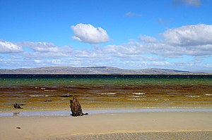
Bertha's Beach Important Bird Area comprises 3,300 hectares of coastal wetlands at the entrance to Choiseul Sound, on the east coast of East Falkland, in the Falkland Islands. It lies about 8 kilometres (5.0 mi) south-east of Mount Pleasant Airport and 40 km south-west of Stanley. It has been identified by BirdLife International as an Important Bird Area (IBA) because of its significancer for a variety of migratory waders and other waterbirds. Overlapping it is the 4000 ha Bertha's Beach Ramsar site, recognising it as a wetland of international importance.
Seal Bay is a bay, about 1 km across, on the rugged and exposed north coast of East Falkland in the Falkland Islands of the South Atlantic Ocean. It lies some 40 km north-west of Stanley.

Chatham Harbour is the large bay indenting the central part of Weddell Island in the Falkland Islands. It is entered east of Beacon Point and west of Loop Head. The 3 km wide bay extends 5 km in southeast direction, this part of the feature forming an anchorage named Bald Road, and north of Clay Point turning for 10 km in southwest direction. Chatham Harbour is centred at 51°50′16″S60°57′32″W.