Willamina Creek

Last updated
Willamina Creek
Country United States
State Oregon
County Yamhill and Tillamook
Source Northern Oregon Coast Range
 - locationYamhill County
 - elevation2,294 ft (699 m) [1]
 - coordinates 45°16′14″N123°24′34″W / 45.27056°N 123.40944°W / 45.27056; -123.40944   [2]
Mouth South Yamhill River
 - location Willamina, Yamhill County
 - elevation217 ft (66 m) [2]
 - coordinates 45°04′42″N123°28′33″W / 45.07833°N 123.47583°W / 45.07833; -123.47583 Coordinates: 45°04′42″N123°28′33″W / 45.07833°N 123.47583°W / 45.07833; -123.47583   [2]
Length20 mi (32 km) [3]
Basin81.6 sq mi (211 km2) [4]
USA Oregon location map.svg
Red pog.svg
Location of the mouth of Willamina Creek in Oregon

Willamina Creek is a tributary, about 20 miles (32 km) long, of the South Yamhill River in the U.S. state of Oregon. [2] [3] Beginning in the Northern Oregon Coast Range in Yamhill County, it briefly enters and exits a small part of eastern Tillamook County, then flows generally south to meet the larger stream at Willamina, near the border with Polk County. [5]

South Yamhill River tributary of the Yamhill River in northwest Oregon

The South Yamhill River is a tributary of the Yamhill River, approximately 60 miles (97 km) long, in northwest Oregon in the United States. It drains an area of the Northern Oregon Coast Range, as well as part of the Willamette Valley west of the Willamette River.

Oregon State of the United States of America

Oregon is a state in the Pacific Northwest region on the West Coast of the United States. The Columbia River delineates much of Oregon's northern boundary with Washington, while the Snake River delineates much of its eastern boundary with Idaho. The parallel 42° north delineates the southern boundary with California and Nevada. Oregon is one of only three states of the contiguous United States to have a coastline on the Pacific Ocean.

Northern Oregon Coast Range mountain in United States of America

The Northern Oregon Coast Range is the northern section of the Oregon Coast Range, in the Pacific Coast Ranges physiographic region, located in the northwest portion of the state of Oregon, United States. This section of the mountain range, part of the Pacific Coast Ranges, contains peaks as high as 3,710 feet (1,131 m) for Rogers Peak. Forests in these mountains are considered to be some of the most productive timber land in the world. The Central Oregon Coast Range is directly south of this section with the Southern Oregon Coast Range beyond the central range.

Contents

Course

From its source northeast of Stony Mountain, the creek flows south, passing under Willamina Creek Road about 18 miles (29 km) above the mouth. The road follows the creek from here to Willamina. Turning west, the creek passes over Willamina Falls between river miles (RM) 17 and 16 (river kilometers 27 and 26) and enters Tillamook County. Veering south again, it flows through segments of Tillamook State Forest before re-entering Yamhill County about 13 miles (21 km) from the mouth. It passes Buck Hollow Cemetery and then flows through Blackwell Park at about RM 5 (RK 8). Turning east at Willamina, it enters the South Yamhill River about 43 miles (69 km) from the larger stream's mouth. Named tributaries of Willamina Creek from source to mouth are Cedar, East, Coast, and Tindle creeks. [3]

River mouth end of a river

A river mouth is the part of a river where the river debouches into another river, a lake, a reservoir, a sea, or an ocean.

Tillamook State Forest

The Tillamook State Forest is a 364,000-acre (1,470 km2) publicly owned forest in the U.S. state of Oregon. Managed by the Oregon Department of Forestry, it is located 40 miles (64 km) west of Portland in the Northern Oregon Coast Range, and spans Washington, Tillamook, Yamhill, and Clatsop counties. The forest receives large amounts of precipitation and is dominated by Douglas-fir trees. Activities include commercial logging, recreation, and other commercial resource extraction activities such as mushroom hunting.

Waterfall

The Northwest Waterfall Survey describes Willamina Falls as a "veiling plunge" that is 40 feet (12 m) high and 20 feet (6 m) wide. [6] It estimates the average discharge at this point at 150 cubic feet per second (4.2 m3/s) with the highest flows in winter and spring. The waterfall is on private land. [6]

In hydrology, discharge is the volumetric flow rate of water that is transported through a given cross-sectional area. It includes any suspended solids (e.g. sediment), dissolved chemicals (e.g. CaCO3(aq)), or biologic material (e.g. diatoms) in addition to the water itself.

Recreation

Blackwell Park is a county recreational area along Willamina Road and the creek about 4.5 miles (7 km) north of Willamina. The 6-acre (2.4 ha) site offers stream views, picnic sites, fishing, barbecue pits, and a public toilet. Two families named Blackwell donated the land for the park in 1957. [7]

Barbecue in the United States

In the United States, barbecue refers to a technique of cooking meat outdoors over a fire; often this is called pit barbecue, and the facility for cooking it is the barbecue pit. This form of cooking adds a distinctive smoky taste to the meat; barbecue sauce, while a common accompaniment, is not required for many styles.

Fishing in Oregon calls the creek "a good little trout stream". [8] The creek offers catch-and-release fishing for wild cutthroat up to 11 inches (28 cm) long. [8]

Cutthroat trout species of fish

The cutthroat trout(Oncorhynchus clarkii) is a fish species of the family Salmonidae native to cold-water tributaries of the Pacific Ocean, Rocky Mountains, and Great Basin in North America. As a member of the genus Oncorhynchus, it is one of the Pacific trout, a group that includes the widely distributed rainbow trout. Cutthroat trout are popular gamefish, especially among anglers who enjoy fly fishing. The common name "cutthroat" refers to the distinctive red coloration on the underside of the lower jaw. The specific name clarkii was given to honor explorer William Clark, coleader of the Lewis and Clark Expedition.

See also

Related Research Articles

Yamhill River river in the United States of America

The Yamhill River is an 11-mile (18 km) tributary of the Willamette River, in the U.S. state of Oregon. Formed by the confluence of the South Yamhill River and the North Yamhill River about 3 miles (5 km) east of McMinnville, it drains part of the Northern Oregon Coast Range. The river meanders east past Dayton to join the Willamette River at its river mile (RM) 55 or river kilometer (RK) 89, south of Newberg.

Siletz River river in the United States of America

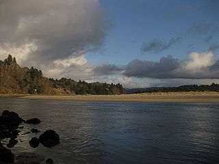
The Siletz River flows about 67 miles (108 km) to the Pacific Ocean through coastal mountains in the U.S. state of Oregon. Formed by the confluence of its north and south forks near Valsetz in Polk County, it winds through the Central Oregon Coast Range. The river, draining a watershed of 373 square miles (970 km2), empties into Siletz Bay, south of Lincoln City in Lincoln County. Although the river travels 67 miles (108 km) in river miles, its winding course begins only about 20 miles (32 km) east of the ocean, and its mouth and source latitudes are almost identical.

North Yamhill River river in the United States of America

The North Yamhill River is a 31-mile (50 km) tributary of the Yamhill River in the U.S. state of Oregon. It drains an area of the Northern Oregon Coast Range, as well as part of the Willamette Valley west of the Willamette River.

Salmon River (Lincoln County, Oregon) river in Lincoln County, Oregon

The Salmon River flows from the Central Oregon Coast Range to the Pacific Ocean coast of northwest Oregon in the United States. About 24 miles (39 km) long, it begins and ends in Lincoln County but also flows briefly through western Polk and southern Tillamook counties. Much of its course lies within the Siuslaw National Forest.

Trask River river in Oregon

The Trask River is in northwestern Oregon in the United States. It drains a mountainous timber-producing area of the Northern Oregon Coast Range west of Portland into Tillamook Bay and the Pacific Ocean. It is one of five rivers—the Tillamook, the Trask, the Wilson, the Kilchis, and the Miami—that flow into the bay.

Wilson River (Oregon) river in the United States of America

The Wilson River, about 33 miles (53 km) long, flows from the Northern Oregon Coast Range to Tillamook Bay in the U.S. state of Oregon. Formed by the confluence of its Devil's Lake Fork and its South Fork, it runs generally west through the Tillamook State Forest to its mouth near the city of Tillamook. It is one of five rivers—the Tillamook, the Trask, the Wilson, the Kilchis, and the Miami—that flow into the bay.

Kilchis River river in the United States of America

The Kilchis River is a stream, about 14 miles (23 km) long, near the coast of northwest Oregon in the United States. It drains a mountainous timbered region of about 65 square miles (170 km2) in the Northern Oregon Coast Range west of Portland.

Miami River (Oregon) river in United States of America

The Miami River is a stream, approximately 13 miles (21 km) long, on the coast of northwest Oregon in the United States. It drains a mountainous timbered region of the Northern Oregon Coast Range west of Portland, into Pacific Ocean.

Tillamook River river in the United States of America

The Tillamook River is a stream, about 17 miles (27 km) long, near the coast of northwest Oregon in the United States. It drains an oceanside valley in the foothills of the Northern Oregon Coast Range west of Portland and empties into the Pacific Ocean via Tillamook Bay. It is one of five rivers—the Tillamook, the Trask, the Wilson, the Kilchis, and the Miami—that flow into the bay.

Abiqua Creek river in Oregon, United States of America

Abiqua Creek is a tributary of the Pudding River in the U.S. state of Oregon. The creek originates near Lookout Mountain in the foothills of the Cascade Range in the northwestern part of the state. It flows northwest for about 29 miles (47 km) to its confluence with the Pudding, about 2 miles (3.2 km) west of Silverton, in the Willamette Valley. About 20 miles (32 km) north of Silverton, the Pudding River meets the Molalla River, which meets the Willamette River less than 1 mile (1.6 km) later near Canby.

Umatilla River tributary of the Columbia River in Oregon

The Umatilla River is an 89-mile (143 km) tributary of the Columbia River in the U.S. state of Oregon. Draining a basin of 2,450 square miles (6,300 km2), it enters the Columbia near the city of Umatilla in the northeastern part of the state. In downstream order, beginning at the headwaters, major tributaries of the Umatilla River are the North Fork Umatilla River and the South Fork Umatilla River, then Meacham, McKay, Birch, and Butter creeks.

Row River river in the United States of America

The Row River is a river, approximately 20 miles (32 km) long, in Lane County, Oregon, United States. It rises in the Cascade Range and flows into the Coast Fork Willamette River near Cottage Grove. The stream was originally known as the "East Fork Coast Fork", but was later renamed after a dispute (row) between neighbors and brothers-in-law George Clark and Joseph Southwell over "trespassing" livestock. Clark was killed as a result of the row. The name rhymes with "cow" rather than with "slow". A post office named Row River operated from 1911 to 1914 a little north of the present site of Dorena at 43.740123°N 122.880347°W.

South Fork Rogue River tributary of the Rogue River in Oregon

The South Fork Rogue River is a 25-mile (40 km) tributary of the Rogue River in the U.S. state of Oregon. Rising in the Sky Lakes Wilderness in the Cascade Range, it flows generally northeast through the Rogue River – Siskiyou National Forest to meet the Rogue River downstream of Prospect and slightly upstream of Lost Creek Lake.

Course of the Willamette River

The Willamette River is a 187-mile (301 km) tributary of the Columbia River in the U.S. state of Oregon. The upper tributaries of the Willamette originate in mountains south and southeast of Eugene and Springfield. Formed by the confluence of the Middle Fork Willamette River and Coast Fork Willamette River near Springfield, the main stem meanders generally north from source to mouth. The river's two most significant course deviations occur at Newberg, where the stream turns sharply east, and about 18 miles (29 km) downriver from Newberg, where it turns north again. Near its mouth, the river splits into two channels that flow around Sauvie Island. The main channel enters the Columbia about 101 miles (163 km) from the larger stream's mouth on the Pacific Ocean, and the smaller Multnomah Channel enters the Columbia about 14.5 miles (23.3 km) further downstream near St. Helens in Columbia County.

West Fork Millicoma River river in the United States of America

The West Fork Millicoma River is a tributary, about 34 miles (55 km) long, of the Millicoma River in the U.S. state of Oregon. Rising in northeastern Coos County near the Douglas County line, it flows generally southwest through the Elliott State Forest of the Southern Oregon Coast Range to the community of Allegany. There it joins the East Fork Millicoma River to form the Millicoma. In turn, the Millicoma, which is only about 9 miles (14 km) long, joins the South Fork Coos River to form the Coos River. The Coos River, itself only about 5 miles (8 km) long, empties into the eastern end of Coos Bay, which connects to the Pacific Ocean.

South Fork Coos River river in the United States of America

The South Fork Coos River is a tributary, about 32 miles (51 km) long, of the Coos River in the U.S. state of Oregon. Formed by the confluence of the Williams River and Tioga Creek, it begins in eastern Coos County near the Douglas County line and flows generally northwest through the Southern Oregon Coast Range. East of the city of Coos Bay, it joins the Millicoma River to form the Coos River. This larger river, only about 5 miles (8 km) long, empties into the eastern end of Coos Bay, which connects to the Pacific Ocean.

Williams River (Oregon) river in the United States of America

The Williams River is a tributary, about 21 miles (34 km) long, of the South Fork Coos River in the U.S. state of Oregon. Formed by the confluence of Lost Creek and Little Cow Creek, it begins in western Douglas County near the Coos County line and flows generally northwest through the Southern Oregon Coast Range. In eastern Coos County, it joins Tioga Creek to form the South Fork Coos River about 32 miles (51 km) from its confluence with the Millicoma River.

Little Luckiamute River river in the United States of America

The Little Luckiamute River is a stream in Polk County in the U.S. state of Oregon. It rises in the Central Oregon Coast Range near Fanno Peak and joins the Luckiamute River about 4 miles (6 km) upstream of the Sarah Helmick State Recreation Site southwest of Monmouth.

References

  1. Source elevation derived from Google Earth search using GNIS source coordinates.
  2. 1 2 3 4 "Willamina Creek". Geographic Names Information System. United States Geological Survey (USGS). November 28, 1980. Retrieved February 27, 2015.
  3. 1 2 3 United States Geological Survey. "United States Geological Survey Topographic Map". Acme Mapper. Retrieved February 28, 2015. The map quadrants include river-mile (RM) markers to RM 17.8. The remaining distance is an estimate based on map scale and ruler.
  4. Yamhill Basin Council (2002). Bash, Jeff; Ishii, Jeanine, eds. "Upper South Yamhill River Watershed Assessment" (PDF). Oregon Department of Fish and Wildlife. p. 6. Retrieved February 27, 2015.
  5. Oregon Atlas & Gazetteer (7th ed.). Yarmouth, Maine: DeLorme. 2008. p. 27. ISBN   978-0-89933-347-2.
  6. 1 2 "Willamina Falls". Northwest Waterfall Survey. 2015. Retrieved February 28, 2015.
  7. "Blackwell". Yamhill County. 2015. Retrieved February 28, 2015.
  8. 1 2 Sheehan, Madelyne Diness (2005). Fishing in Oregon: The Complete Oregon Fishing Guide (10th ed.). Scappoose, Oregon: Flying Pencil Publications. p. 194. ISBN   0-916473-15-5.