
The Barrio de Analco Historic District is a National Historic Landmark District centered at the junction of East De Vargas Street and Old Santa Fe Trail in Santa Fe, New Mexico. The seven buildings of the district represent one of the oldest clusters of what were basically working-class or lower-class residences in North America, and are in a cross-section of pre-statehood architectural styles. It includes two of the oldest colonial-era buildings in the southwest, the San Miguel Mission church (1710), and the "Oldest House", built in 1620 and now a museum. The district was declared a National Historic Landmark in 1968.

The Whitney Avenue Historic District is a historic district in the East Rock neighborhood of New Haven, Connecticut. It is a 203-acre (82 ha) district which included 1,084 contributing buildings when it was listed on the National Register of Historic Places in 1989.
The National Register of Historic Places listings in Syracuse, New York are described below. There are 119 listed properties and districts in the city of Syracuse, including 19 business or public buildings, 13 historic districts, 6 churches, four school or university buildings, three parks, six apartment buildings, and 43 houses. Twenty-nine of the listed houses were designed by architect Ward Wellington Ward; 25 of these were listed as a group in 1996.

The Rochelle Park–Rochelle Heights Historic District is a historic residential district located in the city of New Rochelle in Westchester, New York. The district is historically and architecturally significant as an intact and distinctive example of residential park development at the turn of the Twentieth Century. It includes the historic Rochelle Park development, and the later Rochelle Heights subdivision. Within the district are 555 contributing properties, including 513 buildings, 38 structures, and 4 sites. Only 24 buildings and 1 site separately identified within its area are non-contributing. It was listed on the National Register of Historic Places (NRHP) on July 6, 2005.

This is a list of National Register of Historic Places listings in New Haven, Connecticut.
Beaver Hills is a neighborhood in the city of New Haven, Connecticut. The older, east central portion of the neighborhood is listed on the National Register of Historic Places as the Beaver Hills Historic District. The southwest portion is a state historic district called the Fairlawn-Nettleton Historic District.

The Beaver Hills Historic District is a 97-acre (39 ha) historic district in the Beaver Hills neighborhood of New Haven, Connecticut. It was listed on the National Register of Historic Places in 1986. In 1986, it included 235 contributing buildings.
In the United States, the National Register of Historic Places classifies its listings by various types of architecture. Listed properties often are given one or more of 40 standard architectural style classifications that appear in the National Register Information System (NRIS) database. Other properties are given a custom architectural description with "vernacular" or other qualifiers, and others have no style classification. Many National Register-listed properties do not fit into the several categories listed here, or they fit into more specialized subcategories.

The Hamburg Historic District, also known as the Gold Coast, is a residential neighborhood located on a bluff northwest of downtown Davenport, Iowa, United States. It is listed on the National Register of Historic Places in 1983. In 1999, it was listed on the Davenport Register of Historic Properties The historic district is where the city's middle and upper-income German community built their homes in the 19th and early 20th centuries. Germans were the largest ethnic group to settle in Davenport.

Nob Hill is a neighborhood in Albuquerque, New Mexico, United States, consisting of a commercial district along Central Avenue and surrounding residential areas. Located just east of the University of New Mexico, the neighborhood was developed between about 1925 and 1950 and has since become a popular tourist and shopping destination. Known for its eclectic mix of mostly locally owned businesses, Nob Hill has been described as "the heart of Albuquerque's Route 66 culture and also its hippest, funkiest retail and entertainment district". The neighborhood is named after Nob Hill in San Francisco, California.
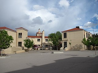
Monte Vista Elementary School is a public elementary school in the Nob Hill neighborhood of Albuquerque, New Mexico, whose campus is listed in the New Mexico State Register of Cultural Properties and the National Register of Historic Places. It is notable as one of the city's best examples of Mediterranean Revival architecture and as the historical focal point of the surrounding neighborhood. It is a part of Albuquerque Public Schools.

Monte Vista Fire Station is a historic former fire station in the Nob Hill neighborhood of Albuquerque, New Mexico. Built in 1936 using Works Progress Administration funding, it is notable as a well-preserved WPA municipal project and for its significance in the early development of the Nob Hill area. The building served in its original role as a fire station until 1972 and currently houses a restaurant. It is the city's third oldest surviving fire station after the AT&SF Fire Station, built in 1920, and the old station #2 on the corner of High St. and Silver Ave. opened in 1926.

Huning Highlands, also known as EDo or East Downtown, is an inner-city neighborhood in Albuquerque, New Mexico, directly east of Downtown. It is a mostly residential area known for its high concentration of Victorian and early 20th-century houses and is listed on the National Register of Historic Places as the Huning Highlands Historic District. There is also a commercial district along the main thoroughfares, Central Avenue and Broadway Boulevard. Huning Highlands was developed starting in 1880 and is named for Franz Huning, a prominent businessman at the time.

The Camino del Monte Sol Historic District, in Santa Fe, New Mexico, is a 52.1 acres (21.1 ha) historic district which was listed on the National Register of Historic Places in 1988. The listing included 106 contributing buildings.
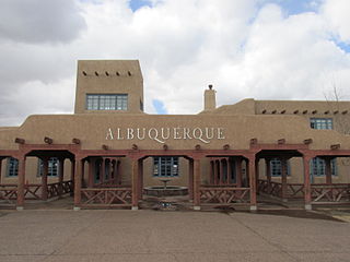
The OldAlbuquerque Municipal Airport Building at 2920 Yale Blvd. SE. in Albuquerque, New Mexico, is a Pueblo Revival building built in 1939. It was listed on the National Register of Historic Places in 1989.
The Huning Highlands Historic District is a historic district in Albuquerque, New Mexico which encompasses the entirety of the Huning Highlands neighborhood. The district is bounded by Dr. Martin Luther King Jr. Avenue to the north, Locust Street to the east, Iron Avenue to the south, and the Burlington Northern Santa Fe railroad tracks to the west, covering an area of about 0.3 square miles (0.78 km2). The neighborhood was Albuquerque's first residential subdivision and was mostly developed between the 1880s and 1920s. It is known for its high concentration of Victorian and early 20th-century houses. The district was added to the New Mexico State Register of Cultural Properties in 1976 and the National Register of Historic Places in 1978.

The Fourth Ward Historic District is a historic district in Albuquerque, New Mexico which encompasses an area between Downtown and Old Town which is roughly bounded by Central Avenue, 8th Street and Keleher Avenue, Lomas Boulevard, and 15th Street. It is named for its location in the city's former fourth political ward. The district is almost entirely residential and developed at a "leisurely pace" between the 1880s and 1930s. As a result, it includes houses in a wide variety of sizes and styles including Queen Anne, Italianate, Tudor, Dutch Colonial, Prairie School, Mediterranean, Pueblo, Territorial, Mission, and Bungalow. The district was added to the New Mexico State Register of Cultural Properties in 1979 and the National Register of Historic Places in 1980.

The Manzano Court Addition Historic District is a historic district in the Downtown Neighborhood of Albuquerque, New Mexico. It encompasses the entirety of the Manzano Court Addition, a small subdivision consisting of a one-block-long cul-de-sac and twelve surrounding houses, eight of which are contributing properties. The subdivision was platted in 1923 by Anna Swetland Gotshall (1892–1985), an Ohio native who came to Albuquerque for tuberculosis treatment. Gotshall also designed and built the subdivision's first eight houses between 1925 and 1928. Four additional houses were completed later. The district was added to the New Mexico State Register of Cultural Properties in 2003 and the National Register of Historic Places in 2004.


