
Livingston Manor is a hamlet in Sullivan County, New York, United States. The population was 1,221 at the 2010 census.

Roscoe is a hamlet in Sullivan County, New York, United States. The population was 541 at the 2010 census.

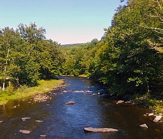
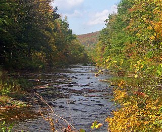
The Beaver Kill, sometimes written as the Beaverkill or Beaverkill River, is a tributary of the East Branch Delaware River, a main tributary of the Delaware River, approximately 44 miles (71 km) long, in the U.S. state of New York. The kill drains a 300-square-mile (780 km2) area of the Catskill Mountains and has long been celebrated as one of the most famous trout streams in the United States. Its preservation helped establish many of the basic conservation principles of rivers in the United States.

The East Branch Delaware River is one of two branches that form the Delaware River. It is approximately 75 mi (121 km) long, and flows through the U.S. state of New York. It winds through a mountainous area on the southwestern edge of Catskill Park in the Catskill Mountains for most of its course, before joining the West Branch along the northeast border of Pennsylvania with New York. For a long stretch it serves as the Blue Line, the park's boundary. Much of it is paralleled by State Route 30.
The Neversink River is a 55-mile-long (89 km) tributary of the Delaware River in southeastern New York in the United States. The name of the river comes from the corruption of an Algonquian language phrase meaning "mad river."
Rondout Creek is a 63.3-mile-long (101.9 km) tributary of the Hudson River in Ulster and Sullivan counties, New York, United States. It rises on Rocky Mountain in the eastern Catskills, flows south into Rondout Reservoir, part of New York City's water supply network, then into the valley between the Catskills and the Shawangunk Ridge, where it goes over High Falls and finally out to the Hudson at Kingston, receiving along the way the Wallkill River.
De Bruce is a small hamlet located in Sullivan County, New York, United States.

Esopus Creek is a 65.4-mile-long (105.3 km) tributary of the Hudson River that drains the east-central Catskill Mountains in the U.S. state of New York. From its source at Winnisook Lake on the slopes of Slide Mountain, the Catskills' highest peak, it flows across Ulster County to the Hudson at Saugerties. Many tributaries extend its watershed into neighboring Greene County and a small portion of Delaware County. Midway along its length, it is impounded at Olive Bridge to create Ashokan Reservoir, the first of several built in the Catskills as part of New York City's water supply system. Its own flow is supplemented 13 miles (21 km) above the reservoir by the Shandaken Tunnel, which carries water from the city's Schoharie Reservoir into the creek.

Bowman Creek is a tributary of the Susquehanna River in Luzerne County and Wyoming County, in Pennsylvania, in the United States. It is approximately 26 miles (42 km) long and flows through Ross Township and Lake Township in Luzerne County and Noxen Township, Monroe Township, and Eaton Township in Wyoming County. The watershed of the creek has an area of 120 square miles (310 km2). The creek is not designated as an impaired waterbody and its pH is close to neutral, although it has experienced some problems with acid rain. It has low concentrations of dissolved solids like calcium. The creek is relatively small in its upper reaches, but by Noxen, its width is 40 to 60 feet. It is also relatively shallow in many reaches. Rock formations in the watershed include the Catskill Formation, the Huntley Mountain Formation, Burgoon Sandstone, the Mauch Chunk Formation, the Pottsville Group, and the Pocono Formation. Soil associations in the creek's watershed include the Wellsboro-Morris-Oquaga association, the Oquaga-Lackawanna-Arnot association, the Mardin-Bath-Volusia association, and the Wyoming-Pope association.
The Catskill Fly Fishing Center and Museum is a nonprofit, educational organization dedicated to: preserving America's fly fishing heritage; teaching its future generations of fly fishers; and protecting its fly fishing environment. The museum is located along Willowemoc Creek in the heart of the Catskills at 1031 Old Route 17 in Livingston Manor, New York.

The Beaverkill Valley Inn, formerly known as The Bonnie View, is located off Beaverkill Road north of Lew Beach, New York, United States. It is a large wooden hotel built near the end of the 19th century.

Catskill Creek is a 46.0-mile-long (74.0 km) tributary of the Hudson River that drains the northeastern Catskill Mountains of the U.S. State of New York. From its source at Franklinton Vlaie in Schoharie County it flows southeast through parts of Albany County and Greene County to its mouth at the village of Catskill on the Hudson River.

West Creek is a tributary of Fishing Creek, in Columbia County and Sullivan County, in Pennsylvania, in the United States. It is 9.1 miles (14.6 km) long and flows through Davidson Township in Sullivan County and Jackson Township, Sugarloaf Township, Benton Township, and Benton in Columbia County. The water temperature of the creek ranges from 0 °C (32 °F) to 25 °C (77 °F). The discharge ranges from nearly zero to ten cubic meters per second. Rock formations in the watershed include the Trimmers Rock Formation, the Catskill Formation, and the Huntley Mountain Formation. The creek's watershed has an area of 16.6 square miles (43 km2), most of which is agricultural, forested, or urban land. A small number of dams, mills, and schoolhouses were built on West Creek in the 19th and early 20th century. West Creek has the highest level of biodiversity of any stream in the upper Fishing Creek watershed.

Fisher Run is a tributary of Catawissa Creek in Columbia County, Pennsylvania, in the United States. It is approximately 2.9 miles (4.7 km) long and flows through Main Township and Beaver Township. The stream is impaired by acid mine drainage. It is considered to be a high-quality coldwater fishery and Class A Wild Trout Waters. The watershed of the stream has an area of 3.03 square miles (7.8 km2).
Mine Gap Run is a tributary of Catawissa Creek in Columbia County, Pennsylvania, in the United States. It is approximately 1.5 miles (2.4 km) long and flows through Roaring Creek Township and Beaver Township. The watershed of the stream has an area of 0.92 square miles (2.4 km2). The stream is polluted and acidic. However, it is considered to be a coldwater fishery. The main rock formations in the stream's watershed are the Mauch Chunk Formation, the Spechty Kopf Formation, the Pocono Formation, and the Buddys Run Member of the Catskill Formation.

Long Hollow is a tributary of Catawissa Creek in Columbia County, Pennsylvania, in the United States. It is approximately 2.5 miles (4.0 km) long and flows through Roaring Creek Township and Beaver Township. The watershed of the stream has an area of 2.84 square miles (7.4 km2). The stream has a neutral pH and is considered to be a coldwater fishery. The main rock formations in the stream's watershed are the Mauch Chunk Formation, the Spechty Kopf Formation, the Pocono Formation, and the Buddys Run Member of the Catskill Formation.
East Kill, a 16-mile-long (26 km) tributary of Schoharie Creek, flows across the town of Jewett, New York, United States, from its source on Stoppel Point. Ultimately its waters reach the Hudson River via the Mohawk. Since it drains into the Schoharie upstream of Schoharie Reservoir, it is part of the New York City water supply system. East Kill drains the southern slopes of the Blackhead Mountains, which include Thomas Cole Mountain, Black Dome, and Blackhead Mountain, the fourth-, third-, and fifth-highest peaks in the Catskills, respectively.
The West Kill, an 11-mile-long (18 km) tributary of Schoharie Creek, flows through the town of Lexington, New York, United States, from its source on Hunter Mountain, the second-highest peak of the Catskill Mountains. Ultimately its waters reach the Hudson River via the Mohawk. Since it drains into the Schoharie upstream of Schoharie Reservoir, it is part of the New York City water supply system. It lends its name to both a mountain to its south and a small town midway along its length.
