Van Tran Flat Bridge

Last updated

Van Tran Flat Bridge
Van-tran-flat-bridge.jpg
The Van Tran Flat Bridge, image taken from the Willowemoc Creek
Coordinates 41°54′53″N74°49′55″W / 41.91472°N 74.83194°W / 41.91472; -74.83194
CarriesVehicle traffic
Crosses Willowemoc Creek
Locale Rockland, New York
Other name(s)
  • Motts Flats Bridge
  • Livingston Manor Covered Bridge
  • Van Tran Bridge
Maintained bySullivan County, New York
Characteristics
Design Covered bridge
Total length117 ft (36 m) (disputed)
Width16 ft 6 inches (5.0 m)
Load limit5 tons
Clearance above 7 ft 8 inches
No. of lanes Single span
History
Constructed byJohn Davidson
Construction end1860
Opened1860, reopened in 1985
Closed1972 (temporarily)
Location
Van Tran Flat Bridge

The Van Tran Flat Bridge (also known as the Motts Flats Bridge, the Livingston Manor Covered Bridge, or the Van Tran Bridge) is a wooden, single span covered bridge that crosses Willowemoc Creek in the town of Rockland, in Sullivan County, New York. The bridge was built in 1860 by John Davidson and features a town lattice truss and a laminated arch system. This makes the Van Tran Flat Bridge the oldest surviving covered bridge in Sullivan County. The bridge was closed and abandoned in 1972, but restoration began in 1984 and reopened the next year. The Van Tran Flat Bridge is a disputed 117 feet (36 m) in length, and leads to Livingston Manor Covered Bridge County Park.

Contents

Description

The Van Tran Flat Bridge is a wooden, single span covered bridge located 1 mile (1.6 km) outside of Livingston Manor, New York. Its assigned covered bridge number is NY-53-05. [1] The bridge was constructed from timber and followed a similar design to other bridges in the Catskill region. [2] [3] This bridge features a town lattice truss and a laminated arch system. The total weight capacity is 10,000 pounds (4,500 kg), the clear width is 11 feet (3.4 m), the out-to-out [lower-alpha 1] width is 16.5 feet (5.0 m), and the vertical clearance is 7.6 feet (2.3 m). [1] The sides are made of wood, have an opening under their eaves, and at each end of the bridge there are 4 buttresses spanning the height of the bridge. [1] [3] [4]

The two openings to the bridge are uniform with each other and the gable stones have a flat, chamfered design. The roof is made of metal. The north-facing abutment is made of stone and concrete, while the south-facing abutment is made of concrete. [1] The exact dimensions of the bridge are disputed amongst sources. Two accounts from 1952 and 1974 claim the bridge is 98 feet (30 m) in length and 43 feet (13 m) across. [2] [5] The New York State Covered Bridge Society claims the bridge is 117 ft length, the originally reported length when constructed. [4] [3] Sullivan County claims the bridge is 103 feet (31 m) in length. [6]

Associated locations

The Van Tran Flat Bridge leads to the Livingston Manor Covered Bridge Park, and is located adjacent to the original homestead of Nobel laureate Dr. John Mott. [1] [7] [8]

History

The Van Tran Flat Bridge (originally named the Motts Flats Bridge, [6] later referred to as the Livingston Manor Covered Bridge [6] or the Van Tran Bridge [4] ) was first constructed in 1860 by John Davidson to cross the Willowemoc Creek. This was an extension of Covered Bridge Road in the town of Rockland, in Sullivan County, New York. [8] [6] The Van Tran Flat Bridge was constructed 5 years before the Beaverkill Covered Bridge, also built by John Davidson. This makes the Van Tran Flat Bridge the oldest of the 4 covered bridges in Sullivan County still standing. [4] [2] [3]

Describing the original proposal for the bridge, the Youngsville Local Record newspaper recounted: [9] [10]

"That the sum of two hundred and fifty dollars be levied and assessed upon the county of Sullivan, and paid to the Commissioner of Highways of the town of Rockland to be applied on the building of a bridge over the Willowemock Creek, on the road leading from Liberty to the West field Flats, near the house of Erastus Sprague in said town of Rockland."

In 1925, the bridge suffered minor damage in a flood. During this time, the bridge was bypassed by New York State Route 17. [11] On August 26, 1940, the Van Tran Flat Bridge's decking was damaged by a loaded truck when it veered off the bridge into the Willowemoc Creek. Repair of the bridge involved $437.75 worth of materials and $174.80 in labor, with 8 workers being responsible for the repairs. [4] Some time after 1958, the bridge's dry-laid stone abutments were refaced with concrete. [7] [3] [6]

In 1972, the bridge was closed and abandoned. In 1984, the Sullivan County's Department of Public Works, in conjunction with Milton S. Graton, began restoring the bridge using original construction techniques. [3] The work included replacement of the truss, chords, floor, roof, and treenails, along with removal of the original queenpost truss. A decision was also made to increase the bridge's load limit, which was achieved by the addition of laminated arches. The bridge was reopened in November 1985. [7] [3] [6]

Today, the bridge is owned and maintained by Sullivan County, New York, and is open to cars. The New York State Covered Bridge Society has classified the Van Tran Flat Bridge as one of 24 "authentic" historic covered bridges in the state of New York. The placard next to the bridge claims it is on both the State and National Register of Historic Places. [lower-alpha 2] [4] [8] [3]

See also

Notes

  1. Also known as total width
  2. While the placard next to the bridge claims it is on both the State and National Register of Historic Places, this is incorrect. [3]

Related Research Articles

<span class="mw-page-title-main">Livingston Manor, New York</span> CDP and hamlet in New York, United States

Livingston Manor is a hamlet in Sullivan County, New York, United States. The population was 1,053 at the 2020 census.

<span class="mw-page-title-main">Beaverkill Bridge</span> Bridge in NY, USA

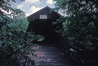
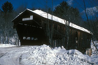
Beaverkill Bridge, also known as Conklin Bridge, is a wooden covered bridge over the Beaver Kill north of the hamlet of Roscoe in the Town of Rockland, New York, United States, that carries Conklin Road through Beaverkill State Campground. It was erected in 1865, one of the first bridges over the river in what was then still a largely unsettled region of the Catskill Mountains.

<span class="mw-page-title-main">Bendo Bridge</span> Bridge

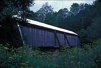
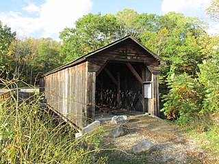
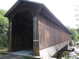
Bendo Bridge is a wooden covered bridge over Willowemoc Creek in the town of Rockland, in Sullivan County, New York. This single 48 foot span Town lattice truss bridge was built by John Davidson in 1860 in Livingston Manor and then moved to its current location in 1913.

<span class="mw-page-title-main">Cogan House Covered Bridge</span> Covered bridge in Pennsylvania, US

The Cogan House Covered Bridge is a Burr arch truss covered bridge over Larrys Creek in Cogan House Township, Lycoming County, in the U.S. state of Pennsylvania. It was built in 1877 and is 94 feet 2 inches (28.7 m) long. The bridge was placed on the National Register of Historic Places in 1980, and had a major restoration in 1998. The Cogan House bridge is named for the township and village of Cogan House, and is also known by at least four other names: Buckhorn, Larrys Creek, Day's, and Plankenhorn.

<span class="mw-page-title-main">Sonestown Covered Bridge</span> Covered bridge in Davidson Township, Sullivan County, Pennsylvania

The Sonestown Covered Bridge is a covered bridge over Muncy Creek in Davidson Township, Sullivan County, Pennsylvania built around 1850. It is 110 ft (34 m) long and was placed on the National Register of Historic Places (NRHP) in 1980. It is named for the nearby unincorporated village of Sonestown in Davidson Township, and is also known as the Davidson Covered Bridge. It was built to provide access to a grist mill which operated until the early 20th century.

<span class="mw-page-title-main">Forksville Covered Bridge</span> Bridge over Loyalsock Creek, Pennsylvania

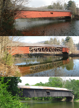
The Forksville Covered Bridge is a Burr arch truss covered bridge over Loyalsock Creek in the borough of Forksville, Sullivan County, in the U.S. state of Pennsylvania. It was built in 1850 and is 152 feet 11 inches (46.61 m) in length. The bridge was placed on the National Register of Historic Places in 1980. The Forksville bridge is named for the borough it is in, which in turn is named for its location at the confluence or "forks" of the Little Loyalsock and Loyalsock Creeks.

<span class="mw-page-title-main">Hillsgrove Covered Bridge</span> Bridge over Loyalsock Creek in Hillsgrove Township, Sullivan County, Pennsylvania

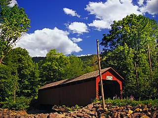
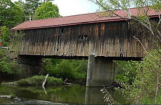
The Hillsgrove Covered Bridge is a Burr arch truss covered bridge over Loyalsock Creek in Hillsgrove Township, Sullivan County, in the U.S. state of Pennsylvania. It was built c. 1850 and is 186 feet (56.7 m) long. In 1973, it became the first covered bridge in the county to be placed on the National Register of Historic Places (NRHP). The bridge is named for the township and nearby unincorporated village of Hillsgrove, and is also known as Rinkers Covered Bridge for an adjoining farm.

<span class="mw-page-title-main">Arthur A. Smith Covered Bridge</span> United States historic place

The Arthur A. Smith Covered Bridge is a historic covered bridge, carrying Lyonsville Road across the North River in Colrain, Massachusetts. Built in 1869, it is the only Burr truss bridge in the state, and is one of a few 19th century covered bridges in the state. It was listed on the National Register of Historic Places in 1983.

<span class="mw-page-title-main">County Route 149 (Sullivan County, New York)</span> County route in New York

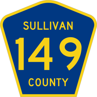
County Route 149 (CR 149) is a 8.69-mile (13.99 km) county route in northern Sullivan County, New York, in the United States. The route runs from an intersection with New York State Route 52 (NY 52) in the Callicoon community of Youngsville to an intersection with CR 178 in the Rockland community of Livingston Manor. CR 149 was originally designated as New York State Route 284 in 1930.

<span class="mw-page-title-main">Stark Covered Bridge</span> United States historic place

The Stark Covered Bridge is a historic wooden covered bridge over the Upper Ammonoosuc River in Stark, New Hampshire. It carries a connecting roadway which joins the Northside Road to New Hampshire Route 110. The bridge was built in either 1857 or 1862, replacing a floating bridge that had been located a short way upstream. It is a two-span Paddleford truss bridge, which is a regional variant of the Long truss. It is 151 feet (46 m) long with a span of 138 feet (42 m), and is 29 feet (8.8 m) wide, carrying an 18-foot (5.5 m) wide roadway and two 6.5-foot (2.0 m) sidewalks. The shore ends of the bridge rest on abutments of granite stone, while the center of the bridge is supported by a reinforced concrete pier, which is flared on the upstream side to deflect debris. The bridge is reinforced with steel beams, giving it a carrying capacity of 15 tons. It is decorated with pendant acorn finials and painted bright white.

<span class="mw-page-title-main">Cold River Bridge (Langdon, New Hampshire)</span> United States historic place

The Cold River Bridge, also known as McDermott Bridge, is a historic wooden covered bridge spanning the Cold River near Crane Brook Road in Langdon, New Hampshire, USA. Built in 1869, it is one of the state's few surviving 19th-century covered bridges. It was listed on the National Register of Historic Places in 1973. It is closed to vehicular traffic.

<span class="mw-page-title-main">Willowemoc Creek</span> River in New York, United States

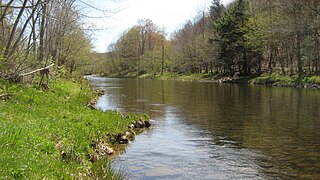
Willowemoc Creek is a tributary of Beaver Kill. It is a popular trout fishing stream near the Catskill Park in Sullivan County, New York.

<span class="mw-page-title-main">Seguin Covered Bridge</span> Bridge in Charlotte, Vermont

The Seguin Covered Bridge, also called the Upper Covered Bridge and the Sequin Covered Bridge, is a wooden covered bridge that crosses Lewis Creek in Charlotte, Vermont on Roscoe Road. It was built about 1850, and is a distinctive variant of a Burr arch design. It was listed on the National Register of Historic Places in 1974.

<span class="mw-page-title-main">Hammond Covered Bridge</span> United States historic place

The Hammond Covered Bridge is a Town lattice covered bridge spanning Otter Creek in Pittsford, Vermont. The bridge was built in 1842 by Asa Norse, and originally carried Kendall Hill Road, which now passes just to its south. The bridge was added to the National Register of Historic Places on January 21, 1974.

<span class="mw-page-title-main">Durgin Bridge</span> United States historic place

The Durgin Bridge is a covered bridge carrying Durgin Bridge Road over the Cold River in eastern Sandwich, New Hampshire. Built in 1869, it is a rare surviving example of a Paddleford truss bridge, and one of the few surviving 19th-century covered bridges in New Hampshire. It was listed on the National Register of Historic Places in 1983.

<span class="mw-page-title-main">Goffstown Covered Railroad Bridge</span> United States historic place

The Goffstown Covered Railroad Bridge was a rare railroad covered bridge in Goffstown, New Hampshire. It was built in 1901 by the Boston and Maine Railroad, on the site of an earlier bridge built in 1850 by the New Hampshire Central Railroad, and carried its tracks across the Piscataquog River in the center of Goffstown. The bridge was listed on the National Register of Historic Places in 1975. It was destroyed by arson in 1976, as would later be the case with the Hillsborough Railroad Bridge in 1985.

<span class="mw-page-title-main">Wright's Bridge</span> United States historic place

Wright's Bridge is a historic covered bridge in Newport, New Hampshire. Originally built in 1906 to carry the Boston and Maine Railroad across the Sugar River, it now carries the multi-use Sugar River Trail. The bridge was listed on the National Register of Historic Places in 1975.

<span class="mw-page-title-main">Porter-Parsonsfield Bridge</span> United States historic place

The Porter-Parsonsfield Bridge is a covered bridge in western Maine, and one of the few 19th-century covered bridges left in the state. The bridge spans the Ossipee River just east of the modern alignment of North Road, which it formerly carried, between the towns of Porter and Parsonsfield. Built in 1876 by the towns, it is a Paddleford truss bridge which has been strengthened with laminated arches. The bridge was closed to traffic in 1960, and is now maintained by the state. It was listed on the National Register of Historic Places in 1970.

<span class="mw-page-title-main">Best's Covered Bridge</span> United States historic place

Best's Covered Bridge(akaSwallow's Bridge) is a historic covered bridge in West Windsor, Vermont, that carries Churchill Road over Mill Creek, just south of Vermont Route 44. Built in 1889, it is an architecturally distinctive laminated arch structure with a post-and-beam superstructure. It was listed on the National Register of Historic Places in 1973.

<span class="mw-page-title-main">Thetford Center Covered Bridge</span> United States historic place

The Thetford Center Covered Bridge is a historic covered bridge, carrying Tucker Hill Road across the Ompompanoosuc River in Thetford, Vermont. It is the state's only known example of the Haupt patent truss system. It was listed on the National Register of Historic Places in 1974.

References

  1. 1 2 3 4 5 Berfield, Rick L. (April 1, 2003). Covered Bridges of New York State: A Guide. Syracuse University Press. ISBN   978-0-8156-0748-9. Archived from the original on December 7, 2023. Retrieved December 6, 2023.
  2. 1 2 3 "A Dozen 'Kissing Bridges' Friendly Havens from the Past". The Kingston Daily Freeman. June 7, 1974. p. 39. Archived from the original on October 23, 2023. Retrieved September 20, 2023.
  3. 1 2 3 4 5 6 7 8 9 "Van Tran Flat | New York State Covered Bridge Society". Archived from the original on September 2, 2022. Retrieved September 1, 2022.
  4. 1 2 3 4 5 6 Kane, Bob; Kane, Trish (October 27, 2014). New York State's Covered Bridges. Arcadia Publishing. pp. 61–63. ISBN   978-1-4396-4805-6. Archived from the original on October 23, 2023. Retrieved September 20, 2023.
  5. Allen, Richard Sanders; Merrill, Arch (1952). "Covered Bridges in New York State". New York History. 33 (1): 84–93. ISSN   0146-437X. JSTOR   24470902. Archived from the original on December 7, 2023. Retrieved December 6, 2023.
  6. 1 2 3 4 5 6 "Livingston Manor Covered Bridge Park | Sullivan County NY". sullivanny.us. Archived from the original on August 20, 2022. Retrieved August 20, 2022.
  7. 1 2 3 Badalato, Fina (October 17, 2021). "Bridges". The Journal News. pp. C3. Archived from the original on October 23, 2023. Retrieved September 20, 2023.
  8. 1 2 3 Badolato, Fina. "9 covered bridges in Ulster, Sullivan counties to check out this fall". Times Herald-Record. Archived from the original on September 2, 2022. Retrieved September 20, 2023.
  9. Local Record (Youngsville), January 1, 1869.
  10. National Society for the Preservation of Covered Bridges. World Guide to Covered Bridges, 2021, page 58
  11. Republican Watchman (Monticello), January 2, 1925.