Worstead is a village and civil parish in the English county of Norfolk. It lies 3 miles (5 km) south of North Walsham, 5 miles (8 km) north of Wroxham, and 13 miles (21 km) north of Norwich. The village is served by Worstead railway station on the Bittern Line. For the purposes of local government, the parish falls within the district of North Norfolk.

Wooburn is a large village in Buckinghamshire, England. It is located off the A4094 road between Wooburn Green and Bourne End in the very south of the county near the River Thames, about two miles south west of Beaconsfield and four miles east of Marlow. Wooburn is one of the two principal settlements within Wooburn, a civil parish in Wycombe district.
Yaxley is a village and civil parish in the Huntingdonshire district in Cambridgeshire, England. Yaxley lies approximately 4 miles (6 km) south of Peterborough, just off the A15 road. The village is located near the Hampton township, and is approximately three miles north-east of junction 16 of the A1(M) at Norman Cross.

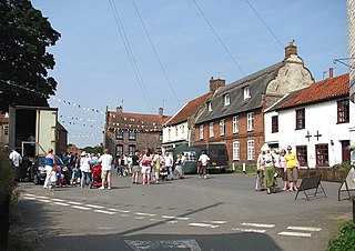
Stilton is a village and civil parish in Cambridgeshire, England, about 12 miles (19 km) north of Huntingdon in Huntingdonshire, which is a non-metropolitan district of Cambridgeshire as well as a historic county of England.

Normanton on Soar, formerly known as Normanton-upon-Soar and known locally as Normanton, is a village and civil parish in the Rushcliffe district of Nottinghamshire, England near the River Soar. This historic village is home to one of the last operating chain ferries in the country, the only lived in cruck building in Nottinghamshire and a 13th-century Grade I listed parish Church.
Sawtry is a village and civil parish in Cambridgeshire, England. Sawtry lies approximately 8 miles (13 km) north of Huntingdon. Sawtry is situated within Huntingdonshire which is a non-metropolitan district of Cambridgeshire as well as being a historic county of England. The village is home to over 6,000 people.

Alconbury is a village and civil parish in Cambridgeshire, England. Alconbury is situated within Huntingdonshire which is a non-metropolitan district of Cambridgeshire as well as being an historic county of England. Alconbury lies approximately 5 miles (8 km) north-west of Huntingdon.

Hartwell is a village and civil parish in West Northamptonshire, bordering Buckinghamshire. The village is next to Salcey Forest and the M1 motorway. It is 7 miles (11 km) south of Northampton and 13 miles (21 km) north of Milton Keynes.
Houghton is a village and former civil parish, now in the parish of Houghton and Wyton, in Cambridgeshire, England, approximately 3 miles (5 km) east of Huntingdon on the A1123 road, and south of RAF Wyton. It lies on the north bank of the River Great Ouse, by Houghton Mill.

Upton is a village and civil parish in the Peterborough district, in the ceremonial county of Cambridgeshire, England. For electoral purposes it forms part of Glinton and Wittering ward in North West Cambridgeshire constituency. The population of the parish is included in the civil parish of Sutton.
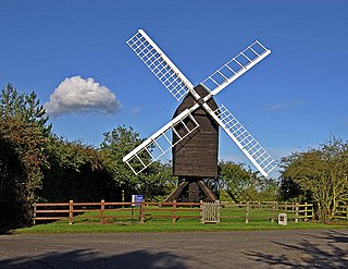
Great Gransden is a civil parish and village in the Huntingdonshire district of Cambridgeshire, England. In 2001, the parish population was 969, which rose to 1,023 at the 2011 Census. It lies 16 miles (25 km) west of Cambridge and 13 miles (21 km) south of Huntingdon. It contains the oldest post mill in England.
Spaldwick is a village and civil parish in Cambridgeshire, England. Spaldwick lies approximately 6 miles (10 km) west of Huntingdon, near Catworth. Spaldwick is situated within Huntingdonshire which is a non-metropolitan district of Cambridgeshire as well as being a historic county of England.
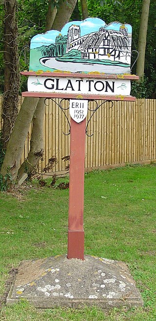
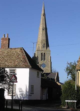
Glatton is a village and civil parish in Cambridgeshire, England, some 8 miles (13 km) south-west of Peterborough, near the villages of Conington, Yaxley and Stilton. It lies in the non-metropolitan district of Huntingdonshire, which is part of Cambridgeshire as well as being a historic county. A World War II airfield built nearby is now known as Peterborough's Conington Airport.

Aiskew is a village in the civil parish of Aiskew and Leeming Bar, in the Hambleton District of North Yorkshire, England. The village is situated to the immediate north-east of Bedale and separated from it by Bedale Beck.

Huby is a village and civil parish in the Hambleton District of North Yorkshire, England, about nine and a half miles north of York and five miles south-east of Easingwold. The village has a small shop, post office, fish and chip shop, a Chinese takeaway, a pub, motel rooms, a Methodist church, a sports ground complete with a pavilion, a B&B motel and a village hall.
Shadwell is a village and civil parish in north-east Leeds, West Yorkshire, England. The village is 6 miles (9.7 km) to the north east of Leeds city centre.

Eppleby is a village and civil parish in the Richmondshire district of North Yorkshire, England. It is located about 7 miles (11 km) north of Richmond. According to the 2011 United Kingdom census, the population of the parish was 269.

Chatburn is a village, civil parish and electoral ward in the Ribble Valley, East Lancashire, England. The population of the civil parish at the 2011 census was 1,102. Situated in a hollow between two ridges north-east of Clitheroe, just off the A59 road, relatively near Pendle Hill south-east of the village. Lanehead quarry is situated to the West at the termination of Chatburn Old Road. Ribble lane at 240 above sea level leads down to the River Ribble North of the village, the top of Downham road being 150 feet higher.

West Bradford is a village and civil parish in Lancashire, England, 27 miles (43 km) west of the larger city of Bradford, West Yorkshire and 2.5 miles (4 km) north of Clitheroe. The population of the civil parish taken at the 2011 census was 788. It covers some 2000 acres of the Forest of Bowland. In Domesday, it is recorded as Bradeford and in the thirteenth century, Braford in Bouland. It was part of the West Riding of Yorkshire until 1974. "West Bradford" was introduced in the nineteenth century at the time of the introduction of postal services to help distinguish the village from its larger eastern neighbour of the same name.
Christchurch is a village in the Fenland district of Cambridgeshire, England. The population of the civil parish at the 2011 Census was 833. The village is sited close to the Cambridgeshire/Norfolk border.

