Winborn, Mississippi

Last updated

Winborn, Mississippi
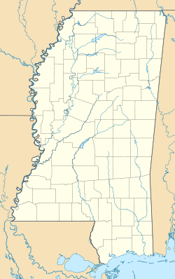
USA Mississippi location map.svg
Red pog.svg
Winborn, Mississippi
Usa edcp location map.svg
Red pog.svg
Winborn, Mississippi
Coordinates: 34°37′52″N89°16′23″W / 34.63111°N 89.27306°W / 34.63111; -89.27306
Country United States
State Mississippi
County Benton
Elevation
367 ft (112 m)
Time zone UTC-6 (Central (CST))
 • Summer (DST) UTC-5 (CDT)
Area code 662
GNIS feature ID695191 [1]

Winborn, also known as Reids Switch, is an unincorporated community in Benton County, Mississippi, United States. [1]

History

The area surrounding Winborn was found to have large deposits of carbonate iron ore. [2] In 1912, businessman from Birmingham chartered the Memphis Mining and Manufacturing Company to process this iron ore. A railroad spur and charcoal blast furnace were constructed. The furnace had a capacity for ten tons per day and produced 125 tons of pig iron before closing. [3] After the furnace closed, the iron ore was mined for paint pigment. [4]

A post office operated under the name Reids Switch from 1902 to 1905 and under the name Winborn from 1905 to 1956. [5]

References

  1. 1 2 U.S. Geological Survey Geographic Names Information System: Winborn
  2. ↑ Ephraim Noble Lowe (1915). Mississippi, Its Geology, Geography, Soils and Mineral Resources. Tucker Printing House. p. 138.
  3. ↑ Kern, Marshall (1963). An Investigation of Mississippi Iron Ores (PDF). Mississippi Geological, Economic and Topographical Survey. pp. 27–8.
  4. ↑ Minerals Yearbook. Bureau of Mines. 1956. p. 640.
  5. ↑ "Benton County". Jim Forte Postal History. Retrieved May 4, 2020.