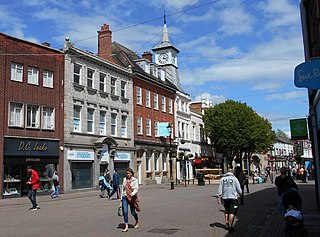
Nuneaton is a market town in Warwickshire, England, close to the county border with Leicestershire to the north-east. Nuneaton's population at the 2021 census was 88,813, making it the largest town in Warwickshire. Nuneaton's urban area, which also includes the large villages of Bulkington and Hartshill, had a population of 99,372 at the 2021 census.

Atherstone is a market town and civil parish in the North Warwickshire district of Warwickshire, England. Located in the far north of the county, Atherstone is on the A5 national route, and is adjacent to the border with Leicestershire which is here formed by the River Anker. It is situated between the towns of Tamworth and Nuneaton. Atherstone is the administrative centre of the North Warwickshire district, with the offices of North Warwickshire Borough Council located in the town.

Barwell is a village and civil parish in Leicestershire, England, with a population of 8,750 residents in 2001, increasing to 9,022 at the 2011 census. The name "Barwell" literally translates as "Stream of the Boar" and is said to originate from a boar that used to drink from the well near a brook in Barwell. It was originally known as "Borewell", but later became "Barwell". The brook is now called the River Tweed, and is a tributary of the River Trent.

Burbage is a large village and civil parish, now generally considered a suburb of the neighbouring town of Hinckley. It is in the Borough of Hinckley and Bosworth in Leicestershire, England, near the border with Warwickshire.

Warwickshire is a ceremonial county in the West Midlands of England. It is bordered by Staffordshire and Leicestershire to the north, Northamptonshire to the east, Oxfordshire and Gloucestershire to the south, and Worcestershire and the West Midlands county to the west. The largest settlement is Nuneaton and the county town is Warwick.

North Warwickshire is a local government district with borough status in Warwickshire, England. The borough includes the two towns of Atherstone and Coleshill, and the large villages of Hartshill, Kingsbury, Mancetter, Polesworth and Water Orton along with smaller villages and surrounding rural areas.

Dadlington is a village and former civil parish, now in the parish of Dadlington and Sutton Cheney, in the Hinckley and Bosworth district, in Leicestershire, England. It is situated between Hinckley, Market Bosworth and Nuneaton. In 1931 the parish had a population of 200.
Polesworth is a large village and civil parish in the North Warwickshire district of Warwickshire, England. It is situated close to the northern tip of Warwickshire, adjacent to the border with Staffordshire. It is 3 miles (5 km) east of Tamworth, and is 4.5 miles (7 km) northwest of Atherstone.

Fenny Drayton is a village and former civil parish, now in the parish of Witherley, in the Hinckley and Bosworth district of Leicestershire, England. It lies near the Warwickshire boundary, three miles south-east of Atherstone in the Coventry postcode area, just off the A444, the Roman Watling Street. Another Roman road crosses at the end of the scenic Fenn Lanes. The village is four miles from Stoke Golding, where Henry VII of England was crowned after the Battle of Bosworth in 1485. The reinterment of Richard III of England on 21 March 2015 started along Fenn Lanes, near the village. In 1931 the parish had a population of 125. On 1 April 1935 the parish was abolished and merged with Witherley, parts also went to Hartshill, Mancetter and Caldecote. The name means "farm/settlement for portage" or "farm/settlement used as a dragging place". "Fenny" reflects the fen-like ground along the Roman road.
Baddesley Ensor is a village and civil parish in the district of North Warwickshire in Warwickshire, England, about three miles west of Atherstone. It runs into the village of Grendon, which forms a parish itself.

Aston Flamville is a village and civil parish in the Blaby district in Leicestershire, England. It is situated near Hinckley, but on the other (eastern) side of the M69. It has a population of 150 and consequently has a parish meeting rather than a parish council. The population at the 2011 census had increased to 311.

Ashby Parva is a village and civil parish in the Harborough district of Leicestershire, England. The parish had a population of 211 according to the 2001 census, increasing to 233 at the 2011 census. The village is in the west of the district, west of the M1 motorway, and nearby Ullesthorpe, Leire and Bitteswell. It is about 3 miles away from Lutterworth. The village was recorded in the Domesday Book. Ashby Parva is the home of the newly built Midlands Roller Arena, which used to host Major League Roller Hockey Europe competitions in the UK. It is the only purpose built inline hockey arena in the UK that is solely for the use of this one sport and it is used by thousands of athletes every year.

Ratcliffe Culey is a village and former civil parish, now in the parish of Witherley, in the Hinckley and Bosworth district, in Leicestershire, England, near the county boundary with Warwickshire. In 1931 the parish had a population of 184.

Shackerstone is a village and civil parish in the Hinckley and Bosworth district of Leicestershire, England. It is situated on the Ashby-de-la-Zouch Canal and the River Sence. According to the 2001 census the parish, which also includes the village of Barton in the Beans, had a population of 811, including Odstone which had risen to 921 at the 2011 census.

Sheepy is a civil parish in the Borough of Hinckley and Bosworth in Leicestershire, England. It contains the villages of Sheepy Magna, Sheepy Parva, Sibson, Wellsborough, Upton, Pinwall and Cross Hands—collectively 449 homes. At the 2001 census, the parish had a population of 1,192, including Orton on the Hill but falling slightly to 1,174 at the 2011 census.

Sibson is a village and former civil parish, now in the parish of Sheepy, in the Hinckley and Bosworth district, in western Leicestershire, England, close to the border with North Warwickshire. It is situated approximately midway between the towns of Hinckley and Measham, and slightly northeast of Atherstone. In 1931 the parish had a population of 264.
Morebarne or Moore Barn is a grange originally belonging to the Abbey of Merevale, near Orton on the Hill in Sparkenhoe Hundred, Leicestershire, England. It is mentioned in possession of Robert Bradshaw in 1567, and as the 'capite' of Robert Bradshaw esq. the brother of John Bradshaw of Orton on the Hill in 1609. They were descendants of Hugh Bradshaw of Nantwich in Lancashire, who purchased the manor in 1546. It was later sold to the Steeles who bought the manor, the estate and the attached "mansion house", sometime after 1640.

The Mythe is a house built on the top of a hill overlooking the town of Tewkesbury, England. There has been a house on the site for nearly a thousand years. The Mythe is the name of the house but it also the name of the surrounding area, about 4 square miles (10 km2), which includes Mythe Chapel. The main road going through it is the A38 or the "Mythe Road". "Mythe" in Old English means the joining of two rivers.

The River Sence is a river which flows in Leicestershire, England. The tributaries of the Sence, including the Saint and Tweed, fan out over much of western Leicestershire from Charnwood Forest and Coalville in the north-east to Hinckley and almost to Watling Street in the south and south-west. Its watershed almost coincides with Hinckley and Bosworth Borough of Leicestershire, which was formed in 1974 by amalgamation of Market Bosworth Rural District and Hinckley Urban District. It flows into the Anker, which in turn flows into the River Tame. It is part of the wider River Trent catchment, which covers much of central England. In 1881, Sebastian Evans wrote that the usual names for this river were Shenton Brook and Sibson Brook.

Grendon is a civil parish which includes both Old Grendon and New Grendon in North Warwickshire, England. Old Grendon is a village situated three miles (5 km) west of Atherstone and five miles (8 km) east of Tamworth centred on the A5. It lies on the north-western tip of Warwickshire, divided from Leicestershire by a small stream and by the River Anker. Also, Grendon has since enlarged and has a population of 1000.

