
Martha's Vineyard, often simply called the Vineyard, is an island in the Northeastern United States, south of Cape Cod in Dukes County, Massachusetts, known for being a popular, affluent summer colony. Martha's Vineyard includes the smaller adjacent Chappaquiddick Island, a peninsula, currently connected to the Vineyard. It is the 58th largest island in the U.S., with a land area of about 96 square miles (250 km2), and the third-largest on the East Coast, after Long Island and Mount Desert Island. Martha's Vineyard constitutes the bulk of Dukes County, which also includes the Elizabeth Islands and the island of Nomans Land.

Nantucket is an island about 30 miles (48 km) south from Cape Cod. Together with the small islands of Tuckernuck and Muskeget, it constitutes the Town and County of Nantucket, a combined county/town government in the state of Massachusetts. Nantucket is the southeasternmost town in both Massachusetts and the New England region.

Somervell County is a county on the Edwards Plateau in the U.S. state of Texas. As of the 2020 census, its population was 9,205. Its county seat is Glen Rose. The county is named for Alexander Somervell, secretary of war for the Republic of Texas.
Reeves County is a county located in the U.S. state of Texas. As of the 2020 census, its population was 14,748. Its county seat and most populous city is Pecos. The county was created in 1883 and organized the next year. It is named for George R. Reeves, a Texas state legislator and colonel in the Confederate Army. It is one of the nine counties that comprise the Trans-Pecos region of West Texas. Reeves County comprises the Pecos micropolitan statistical area.

Palo Pinto County is a county located in the U.S. state of Texas. As of the 2020 census, its population was 28,409. The county seat is Palo Pinto. The county was created in 1856 and organized the following year.

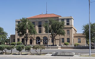
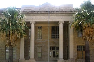
Jack County is a county located in the north central part of the U.S. state of Texas. As of the 2020 census, its population was 8,472. Its county seat is Jacksboro. The county was created in 1856 and organized the next year. It is named for Patrick Churchill Jack and his brother William Houston Jack, both soldiers of the Texas Revolution.

Hansford County is a county located in the U.S. state of Texas. As of the 2020 census, its population was 5,285. Its county seat is Spearman. The county was created in 1876 and organized in 1889. It is named for John M. Hansford, a Texas state congressman and judge.
Dimmit County is a county located in the U.S. state of Texas. As of the 2020 census, its population was 8,615. The county seat is Carrizo Springs. The county was founded in 1858 and later organized in 1880. It is named after Philip Dimmitt, a major figure in the Texas Revolution. The spelling of the county name and the individual's name differ because of a spelling error in the bill creating the county name.

Crockett County is a county located on the Edwards Plateau in the U.S. state of Texas. As of the 2020 census, its population was 3,098. The county seat is Ozona. The county was founded in 1875 and later organized in 1891. It is named in honor of Davy Crockett, the legendary frontiersman who died at the Battle of the Alamo.

Chittenango is a village located in Madison County, New York, United States. The village is in the southern part of the Town of Sullivan. The population was 4,896 at the 2020 census. Chittenango is the birthplace of L. Frank Baum, author of The Wonderful Wizard of Oz.

Bandera is a town in Bandera County, Texas, United States. The county seat, it lies in the Texas Hill Country, a part of the Edwards Plateau located at the crossroads of the central, southern, and western parts of the state, The population was 829 at the 2020 census. approximately 40 miles northwest of San Antonio and 90 miles southwest of Austin, the state capital.

Jacksboro is a city in Jack County, Texas, in the United States. Its population was 4,184 at the 2020 census. U.S. Highways 281 and 380, and Texas State Highways 114 and 199 intersect at Jacksboro, which is the county seat of Jack County.

Orange is a city and the county seat of Orange County, Texas, United States. The population was 19,324 at the 2020 census. It is the easternmost city in Texas, located on the Sabine River at the border with Louisiana, and is 113 miles (182 km) from Houston. Orange is part of the Beaumont−Port Arthur Metropolitan Statistical Area. Founded in 1836, it is a deep-water port to the Gulf of Mexico.
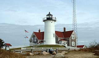
Falmouth is a town in Barnstable County, Massachusetts, United States. The population was 32,517 at the 2020 census, making Falmouth the second-largest municipality on Cape Cod after Barnstable. The terminal for the Steamship Authority ferries to Martha's Vineyard is located in the village of Woods Hole in Falmouth. Woods Hole also contains several scientific organizations such as the Woods Hole Oceanographic Institution (WHOI), the Marine Biological Laboratory (MBL), the Woodwell Climate Research Center, NOAA's Woods Hole Science Aquarium, and the scientific institutions' various museums.

The Elizabeth Islands are a chain of over 20 small islands extending southwest from the southern coast of Cape Cod, Massachusetts in the United States.They are located at the outer edge of Buzzards Bay, north of Martha's Vineyard, from which they are separated by Vineyard Sound, and constitute the town of Gosnold in Dukes County, Massachusetts.

Lavaca Bay is a northwestern extension of the Matagorda Bay system found mostly in Calhoun County, Texas, United States. The ports of Port Lavaca and Point Comfort have been established on the bay, and are the main areas of human habitation. Linnville was located on the bay until its abandonment after the Great Raid of 1840, and the major port of Indianola was found near the confluence with the main Matagorda Bay, until the town's final destruction following the massive hurricane of 1886. Smaller communities include Olivia, Alamo Beach and Magnolia Beach. Lavaca Bay is approximately 82 miles (130 km) northeast of Corpus Christi, about 121 miles (190 km) southwest of Houston, and 145 miles (230 km) southeast of San Antonio.

The Aurora, Texas, UFO incident reportedly occurred on April 17, 1897, when, according to locals, a UFO crashed on a farm near Aurora, Texas. The incident is claimed to have resulted in a fatality of the pilot. The pilot was "not of this world" and was said to be an alien. The pilot was buried at the Aurora cemetery. A stone was placed as a marker for the grave, but has since been removed.

Sisterdale is an unincorporated farming and ranching community established in 1847 and located 13 miles (21 km) north of Boerne in Kendall County, in the U.S. state of Texas. The community is located in the valley of Sister Creek. The elevation is 1,280 feet (390 m).

Carancahua Bay is a northern extension of Matagorda Bay located in Jackson and Matagorda counties in Texas, United States. It is oriented from the southeast to the northwest but meanders as it reaches the north to the confluence with Carancahua Creek. Generally slender, it is only about 1 mile (1.6 km) in width north of its circular mouth.


