
Wood County is a county located in the U.S. state of Texas. As of the 2010 census, its population was 41,964. Its county seat is Quitman. The county was named for George T. Wood, governor of Texas from 1847 to 1849.

University Park is a city in Dallas County, Texas, United States of America, an inner northern suburb of Dallas. The population was 23,068 at the 2010 census. The city is home to Southern Methodist University.

Edward Burleson was the third vice president of the Republic of Texas. After Texas was annexed to the United States, he served in the State Senate. Prior to his government service in Texas, he was a commander of Texian Army forces during the Texas Revolution. Before moving to Texas, he served in militias in Alabama, Missouri, and Tennessee, and fought in the War of 1812. Burleson was the soldier who was given Santa Anna's sword when he surrendered.

The Dallas–Fort Worth metroplex, officially designated Dallas–Fort Worth–Arlington by the U.S. Office of Management and Budget, is a conurbated metropolitan statistical area in the U.S. state of Texas encompassing 11 counties. It is the economic and cultural hub of North Texas. Residents of the area also refer to it as DFW, or the Metroplex. The Dallas–Fort Worth–Arlington metropolitan statistical area's population was 7,573,136 according to the U.S. Census Bureau's 2019 population estimates, making it the most populous metropolitan area in both Texas and the Southern United States, the fourth-largest in the U.S., and the tenth-largest in the Americas. In 2016, the Dallas–Fort Worth metroplex had the highest annual population growth in the United States.
State Highway 249, also known depending on its location as West Mount Houston Road, the Tomball Parkway, Tomball Tollway, MCTRA 249 Tollway, or the Aggie Expressway, is a generally north–south highway in Southeast Texas. The southern terminus is in North Houston at Interstate 45 (I-45). The current northern terminus of the highway is north of Todd Mission at the intersection of FM 1774.
Chisholm Trail Parkway is a toll road operated by the North Texas Tollway Authority (NTTA) in Tarrant and Johnson counties connecting the central business district of the city of Fort Worth at Interstate 30 to US 67 in Cleburne.

State Highway 50 (SH 50) is a 11.679-mile-long (18.796 km) state highway in the northeastern part of the U.S. state of Texas. Its southern terminus is at SH 24 and SH 224 near Commerce. Its northern terminus is at SH 34 in Ladonia. It previously extended northward from Ladonia to Honey Grove, concurrent with SH 34, and southward to Interstate 30 (I-30), concurrent with SH 24. The duplications of these highways were removed in 2003 and 2009, respectively.

State Highway 174 is a state highway in Texas that connects Meridian and Burleson.
Huffman is an unincorporated community of northeastern Harris County, Texas within the Houston, Baytown metropolitan area.

State Highway 211 is a 11.184-mile (17.999 km) state highway west of the city of San Antonio in the U.S. state of Texas. This route was designated in 1986 as an access route to the Texas Research Park. Portions of the route were built, but significant landowner opposition kept the connecting section from being completed. The completed sections of the route consist of a southern section from U.S. Highway 90 north to Farm to Market Road 1957 and a northern section from FM 471 north to SH 16. The Texas Transportation Commission has approved a pass-through toll agreement that Bexar County submitted in October 2008. This proposal will allow for development of a segment of SH 211 from 1.33 miles south of FM 1957 to FM 471 and improvements to FM 1957 from Loop 1604 to the Medina County line. The completion of the section between FM 1957 to FM 471 will finally allow for seamless travel from Hwy 90 at the south end, north to SH 16. The improvements to FM 1957 will allow for the necessary widening of the two-lane roadway which is dealing with new suburban growth and traffic for which it wasn't built to handle.
Farm to Market Road 50 is a Farm to Market Road in the U.S. state of Texas maintained by the Texas Department of Transportation (TxDOT). The 52.9-mile (85.1 km) route begins at State Highway 105 near Brenham and passes to the north through Independence to U.S. Route 79 and U.S. Route 190 near Hearne. The road has a brief concurrency with SH 21 along a bridge crossing the Brazos River. The road is in Washington, Burleson, Brazos, and Robertson counties.
Farm to Market Road 535 is a 33.4-mile (53.8 km) state-maintained roadway located in Bastrop County in the US State of Texas that is a part of the state's Farm to Market Road system.
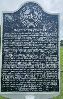
Marystown is an unincorporated community in Johnson County, Texas, United States. It is located at the intersection of FM 917, approximately 10 miles (16 km) northeast of Cleburne.

Lovelace is an unincorporated community in northwestern Hill County in Central Texas. It is located approximately eight miles north of Hillsboro, at the intersection of Texas State Highway 81 and FM 2959.

Rogers Hill is an unincorporated community in McLennan County, located in the U.S. state of Texas. The community is located 18 miles to the north of Waco, and directly to the east of Gholson, Texas.
Wilcox is an unincorporated community in southeastern Burleson County, Texas, near Snook, to the south of College Station at the intersection of SH 50 and Farm Road 1361.
Quil Miller Creek is a stream located in Johnson County, Texas.
Drop is an unincorporated community in Denton County, Texas, located on FM 1384, to the east of Dish and Justin.


