Churchill County is a county in the western U.S. state of Nevada. As of the 2020 census, the population was 25,516. Its county seat is Fallon. Named for Mexican–American War hero brevet Brigadier General Sylvester Churchill, the county was formed in 1861. Churchill County comprises the Fallon, NV Micropolitan Statistical Area. It is in northwestern Nevada. Churchill County is noteworthy in that it owns and operates the local telephone carrier, Churchill County Communications.
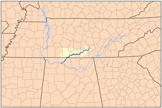
The Elk River is a tributary of the Tennessee River in the U.S. states of Tennessee and Alabama. The river is about 195 miles (314 km) long.

A national recreation area (NRA) is a protected area in the United States established by an Act of Congress to preserve enhanced recreational opportunities in places with significant natural and scenic resources. There are 40 NRAs, which emphasize a variety of activities for visitors, including hiking, camping, boating, fishing, swimming, biking, horseback riding, and wildlife viewing, in areas that include multiple-use management for both conservation and limited utilization of natural resources. They have diverse features and contexts, being established around reservoirs, in urban areas, and within forests. Due to their size, diversity of activities, and proximity to population centers, NRAs are among the most visited units of the National Park System, with six among the thirty most visited sites.
Sam Rayburn Reservoir is a reservoir in the United States in Deep East Texas, 70 miles (110 km) north of Beaumont. The reservoir is fed by the Angelina River, the major tributary of the Neches River. The Reservoir is upstream of the Big Thicket National Preserve.

Beech Fork Lake is a 720 acre (2.9 km2) reservoir located near Lavalette in Wayne County, West Virginia, United States. Beech Fork Lake is also partly located in neighboring Cabell County. Millers Fork and Stowers Branch join Beech Fork with their own river valleys contributing to the majority of the lakesurface of Beech Fork Lake. These streams are tributaries of Twelvepole Creek.

Kanopolis State Park contains a reservoir, desert plants such as yucca, a prairie dog town, and scenic sandstone canyons. It is located in the Smoky Hills region of the U.S. state of Kansas. The park is located southwest of the city of Salina, just south of I-70.

The Whiskeytown–Shasta–Trinity National Recreation Area is a United States National Recreation Area in northern California. The recreation area was authorized in 1965 by the United States Congress. Recreational activities available include swimming, fishing, boating, camping, and hiking.

The East Branch Penobscot River is a 75.3-mile-long (121.2 km) tributary of Maine's Penobscot River. It flows in Piscataquis County and Penobscot County.
Bridgeport State Park is a public recreation area located two miles east of Bridgeport, Washington, on the north shore of Rufus Woods Lake, the Columbia River reservoir created by the Chief Joseph Dam. The state park was built through a partnership between Washington State Parks and the Army Corps of Engineers after completion of the dam in 1955. The park's 25-year lease was renewed in 1990 and again in 2015. The 622-acre (252 ha) park includes 7,500 feet (2,300 m) of shoreline, camping areas, four miles (6.4 km) of hiking trails, and facilities for boating, fishing, swimming, and golf.

Calero Reservoir, also called Calero Lake, is a reservoir in San Jose, California, located in the Calero neighborhood of Almaden Valley in South San Jose. It is the site of Calero County Park, which also includes a large area covering the lake and hundreds of acres of hills around it.

The North Fork Kings River is a 40.3-mile (64.9 km) tributary of the Kings River, in the U.S. state of California. The river's main stem is entirely within Fresno County, and its watershed drains about 387 square miles (1,000 km2) of the southern Sierra Nevada mountain range.
Success Lake is a reservoir in Bridgeport, Connecticut. The elevation of the reservoir is 46 feet. It is located in the 435 acre Lake Success Business Park, which was used to produce ammunition and explosives by the Remington Arms Company from 1905 through 1989 as it was then called "Remington Woods".
