Related Research Articles
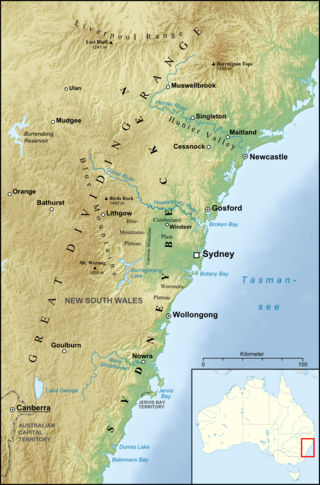
The Sydney Basin is an interim Australian bioregion and is both a structural entity and a depositional area, now preserved on the east coast of New South Wales, Australia and with some of its eastern side now subsided beneath the Tasman Sea. The basin is named for the city of Sydney, on which it is centred.
The geology of Shropshire is very diverse with a large number of periods being represented at outcrop. The bedrock consists principally of sedimentary rocks of Palaeozoic and Mesozoic age, surrounding restricted areas of Precambrian metasedimentary and metavolcanic rocks. The county hosts in its Quaternary deposits and landforms, a significant record of recent glaciation. The exploitation of the Coal Measures and other Carboniferous age strata in the Ironbridge area made it one of the birthplaces of the Industrial Revolution. There is also a large amount of mineral wealth in the county, including lead and baryte. Quarrying is still active, with limestone for cement manufacture and concrete aggregate, sandstone, greywacke and dolerite for road aggregate, and sand and gravel for aggregate and drainage filters. Groundwater is an equally important economic resource.
The Zechstein is a unit of sedimentary rock layers of Late Permian (Lopingian) age located in the European Permian Basin which stretches from the east coast of England to northern Poland. The name Zechstein was formerly also used as a unit of time in the geologic timescale, but nowadays it is only used for the corresponding sedimentary deposits in Europe.
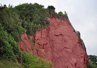
The New Red Sandstone, chiefly in British geology, is composed of beds of red sandstone and associated rocks laid down throughout the Permian to the end of the Triassic, that underlie the Jurassic-Triassic age Penarth Group. The name distinguishes it from the Old Red Sandstone which is largely Devonian in age, and with which it was originally confused due to their similar composition.

One of the classic locations for the study of Triassic sandstones in the UK is at Alderley Edge in Cheshire. Numerous scientists from the early 19th century up to the present day have studied the area and it is a popular field site for universities around the UK.
The geology of Cheshire in England consists mainly of Triassic sandstones and mudstones. To the north west of Cheshire, these rocks are heavily faulted and the underlying Carboniferous Coal Measures are thrown up. Around the areas of Poynton and Macclesfield, the coal is close to the surface and was easily mined. Below the Coal Measures is the Millstone Grit, which appears towards the Derbyshire border on the flanks of the Peak District dome.
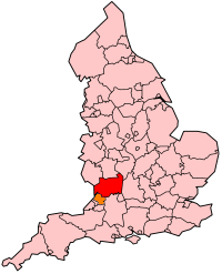
Gloucestershire is one of the most geologically and scenically diverse counties in England, with rocks from the Precambrian through to the Jurassic represented. These varying rock-types are responsible for the three major areas of the county, each with its own distinctive scenery and land-use - the Forest of Dean in the west, bordering Wales, the Cotswolds in the east, and in between, the Severn Vale.
The Cheshire Basin is a late Palaeozoic and Mesozoic sedimentary basin extending under most of the county of Cheshire in northwest England. It extends northwards into the Manchester area and south into Shropshire. The basin possesses something of the character of a half-graben as its deepest extent is along its eastern and southeastern margins, where it is well defined by a series of sub-parallel faults, most important of which is the Red Rock Fault. These faults divide the basin from the older Carboniferous rocks of the Peak District and the North Staffordshire Coalfield.

The Mercia Mudstone Group is an early Triassic lithostratigraphic group which is widespread in Britain, especially in the English Midlands – the name is derived from the ancient kingdom of Mercia which corresponds to that area. It is frequently encountered in older literature as the Keuper Marl or Keuper Marl Series.

The geology of the Isle of Wight is dominated by sedimentary rocks of Cretaceous and Paleogene age. This sequence was affected by the late stages of the Alpine Orogeny, forming the Isle of Wight monocline, the cause of the steeply-dipping outcrops of the Chalk Group and overlying Paleogene strata seen at The Needles, Alum Bay and Whitecliff Bay.
The geology of Lancashire in northwest England consists in the main of Carboniferous age rocks but with Triassic sandstones and mudstones at or near the surface of the lowlands bordering the Irish Sea though these are largely obscured by Quaternary deposits.
The geology of Merseyside in northwest England largely consists of a faulted sequence of Carboniferous Coal Measures rocks overlain in the west by younger Triassic and Permian age sandstones and mudstones. Glaciation during the present Quaternary Period has left widespread glacial till as well as erosional landforms. Other post-glacial superficial deposits such as river and estuarine alluvium, peat and blown sand are abundant.
The geology of County Durham in northeast England consists of a basement of Lower Palaeozoic rocks overlain by a varying thickness of Carboniferous and Permo-Triassic sedimentary rocks which dip generally eastwards towards the North Sea. These have been intruded by a pluton, sills and dykes at various times from the Devonian Period to the Palaeogene. The whole is overlain by a suite of unconsolidated deposits of Quaternary age arising from glaciation and from other processes operating during the post-glacial period to the present. The geological interest of the west of the county was recognised by the designation in 2003 of the North Pennines Area of Outstanding Natural Beauty as a European Geopark.

The North Sea is part of the Atlantic Ocean in northern Europe. It is located between Norway and Denmark in the east, Scotland and England in the west, Germany, the Netherlands, Belgium and France in the south.

The North German Basin is a passive-active rift basin located in central and west Europe, lying within the southeasternmost portions of the North Sea and the southwestern Baltic Sea and across terrestrial portions of northern Germany, Netherlands, and Poland. The North German Basin is a sub-basin of the Southern Permian Basin, that accounts for a composite of intra-continental basins composed of Permian to Cenozoic sediments, which have accumulated to thicknesses around 10–12 kilometres (6–7.5 mi). The complex evolution of the basin takes place from the Permian to the Cenozoic, and is largely influenced by multiple stages of rifting, subsidence, and salt tectonic events. The North German Basin also accounts for a significant amount of Western Europe's natural gas resources, including one of the world's largest natural gas reservoir, the Groningen gas field.

The geology of England's Lake District is dominated by sedimentary and volcanic rocks of mainly Ordovician age underpinned by large granitic intrusions. Younger sedimentary sequences outcrop on the edges of the Lake District area, with Silurian to the south, Carboniferous to the north, east and west and Permo-Triassic to the west and east. The entire area was covered by a Mesozoic sequence that was eroded off during Paleogene uplift related to the opening of the North Atlantic. During the Quaternary the area was affected by repeated glaciations, which sculpted the current mountainous landscape.
The geology of Thailand includes deep crystalline metamorphic basement rocks, overlain by extensive sandstone, limestone, turbidites and some volcanic rocks. The region experienced complicated tectonics during the Paleozoic, long-running shallow water conditions and then renewed uplift and erosion in the past several million years ago.
The geology of Denmark includes 12 kilometers of unmetamorphosed sediments lie atop the Precambrian Fennoscandian Shield, the Norwegian-Scottish Caledonides and buried North German-Polish Caledonides. The stable Fennoscandian Shield formed from 1.45 billion years ago to 850 million years ago in the Proterozoic. The Fennoscandian Border Zone is a large fault, bounding the deep basement rock of the Danish Basin—a trough between the Border Zone and the Ringkobing-Fyn High. The Sorgenfrei-Tornquist Zone is a fault-bounded area displaying Cretaceous-Cenozoic inversion.
The geology of Exmoor National Park in south-west England contributes significantly to the character of Exmoor, a landscape which was designated as a national park in 1954. The bedrock of the area consists almost wholly of a suite of sedimentary rocks deposited during the Devonian, a period named for the English county of Devon in which the western half of the park sits. The eastern part lies within Somerset and it is within this part of the park that limited outcrops of Triassic and Jurassic age rocks are to be found.
A feature of the geology of England, the Stafford Basin extends beneath much of the Midlands county of Staffordshire. It is a depositional basin which was initiated during the Permian period and continued to receive sediment during the Triassic period and probably thereafter. Part of a more extensive set of linked basins, it connects with the Cheshire Basin to the northwest, the Worcester Basin via the Bratch Graben to the south and the Needwood Basin to the east. It is flanked in part to the west by the Coalbrookdale Coalfield and to the east by the South Staffordshire Coalfield. The sedimentary sequence, principally sandstones and mudstones, within the basin is continuous with that of the adjoining basins in the rift complex. Deposition of the Chester Formation for example is ascribed to a river flowing north from the Worcester Basin through the Stafford Basin and on into the Cheshire and East Irish Sea basins during the early Triassic. In contrast the Bridgnorth Sandstone Formation of this area is of aeolian origin, the equivalent of the Collyhurst Sandstone of the Cheshire Basin.
References
- 1 2 3 Chadwick R.A.; Evans D.J. (1995). "The timing and direction of Permo-Triassic extension in southern Britain". In Boldy S.A.R. (ed.). Permian And Triassic Rifting in Northwest Europe. Special Publications. Vol. 91. Geological Society. ISBN 9781897799338.
- ↑ Ambrose K.; Hough E.; Smith N.J.P. & Warrington G. (2014). "Lithostratigraphy of the Sherwood Sandstone Group of England, Wales and south- west Scotland" (PDF). Research Report RR/14/01. British Geological Survey. Retrieved 3 June 2016.
- ↑ Howard A.S., Warrington G., Ambrose K. & Rees J.G. (2008). "A formational framework for the Mercia Mudstone Group (Triassic) of England and Wales" (PDF). Research Report RR/08/04. British Geological Survey. Retrieved 3 June 2016.
{{cite web}}: CS1 maint: multiple names: authors list (link) - ↑ Cox B.M., Sumbler M.G. & Ivimey-Cook H.C. (1999). "A formational framework for the Lower Jurassic of England and Wales (onshore area)" (PDF). Research Report RR/99/01. British Geological Survey. Retrieved 3 June 2016.