
Sedimentary rocks are types of rock that are formed by the accumulation or deposition of mineral or organic particles at Earth's surface, followed by cementation. Sedimentation is the collective name for processes that cause these particles to settle in place. The particles that form a sedimentary rock are called sediment, and may be composed of geological detritus (minerals) or biological detritus. The geological detritus originated from weathering and erosion of existing rocks, or from the solidification of molten lava blobs erupted by volcanoes. The geological detritus is transported to the place of deposition by water, wind, ice or mass movement, which are called agents of denudation. Biological detritus was formed by bodies and parts of dead aquatic organisms, as well as their fecal mass, suspended in water and slowly piling up on the floor of water bodies. Sedimentation may also occur as dissolved minerals precipitate from water solution.

The Entrada Sandstone is a formation in the San Rafael Group found in the U.S. states of Wyoming, Colorado, northwest New Mexico, northeast Arizona, and southeast Utah. Part of the Colorado Plateau, this formation was deposited during the Jurassic Period sometime between 180 and 140 million years ago in various environments, including tidal mudflats, beaches, and sand dunes. The Middle Jurassic San Rafael Group was dominantly deposited as ergs in a desert environment around the shallow Sundance Sea.
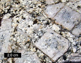
The matrix or groundmass of a rock is the finer-grained mass of material in which larger grains, crystals, or clasts are embedded.

Dorset is a county in South West England on the English Channel coast. Covering an area of 2,653 square kilometres (1,024 sq mi); it borders Devon to the west, Somerset to the north-west, Wiltshire to the north-east, and Hampshire to the east. The great variation in its landscape owes much to the underlying geology, which includes an almost unbroken sequence of rocks from 200 to 40 million years ago (Mya) and superficial deposits from 2 Mya to the present. In general, the oldest rocks appear in the far west of the county, with the most recent (Eocene) in the far east. Jurassic rocks also underlie the Blackmore Vale and comprise much of the coastal cliff in the west and south of the county; although younger Cretaceous rocks crown some of the highpoints in the west, they are mainly to be found in the centre and east of the county.

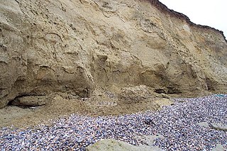
Poole Bay is a bay in the English Channel, on the coast of Dorset in southern England, which stretches 16 km from Sandbanks at the mouth of Poole Harbour in the west, to Hengistbury Head in the east. Poole Bay is a relatively shallow embayment and consists of steep sandstone cliffs and several 'chines' that allow easy access to the sandy beaches below. The coast along the bay is continuously built up, and is part of the South East Dorset conurbation, including parts of the towns of Poole, Bournemouth and Christchurch. The bay is sometimes referred to as Bournemouth Bay, because much of it is occupied by Bournemouth.
In geology, the Bagshot Beds are a series of sands and clays of shallow-water origin, some being fresh-water, some marine. They belong to the upper Eocene formation of the London and Hampshire basins, in England and derive their name from Bagshot Heath in Surrey. They are also well developed in Hampshire, Berkshire and the Isle of Wight. The following divisions are generally accepted:
The Perth Basin is a thick, elongated sedimentary basin in Western Australia. It lies beneath the Swan Coastal Plain west of the Darling Scarp, representing the western limit of the much older Yilgarn Craton, and extends further west offshore. Cities and towns including Perth, Busselton, Bunbury, Mandurah and Geraldton are built over the Perth Basin.
The Wealden Group, occasionally also referred to as the Wealden Supergroup, is a group in the lithostratigraphy of southern England. The Wealden group consists of paralic to continental (freshwater) facies sedimentary rocks of Berriasian to Aptian age and thus forms part of the English Lower Cretaceous. It is composed of alternating sands and clays. The sandy units were deposited in a flood plain of braided rivers, the clays mostly in a lagoonal coastal plain.

The Clarens Formation is a geological formation found in several localities in Lesotho and in the Free State, KwaZulu-Natal, and Eastern Cape provinces in South Africa. It is the uppermost of the three formations found in the Stormberg Group of the greater Karoo Supergroup rocks and represents the final phase of preserved sedimentation of the Karoo Basin.
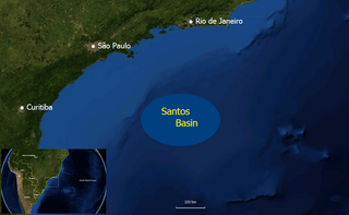
The Santos Basin is an approximately 352,000 square kilometres (136,000 sq mi) large mostly offshore sedimentary basin. It is located in the south Atlantic Ocean, some 300 kilometres (190 mi) southeast of Santos, Brazil. The basin is one of the Brazilian basins to have resulted from the break-up of Gondwana since the Early Cretaceous, where a sequence of rift basins formed on both sides of the South Atlantic; the Pelotas, Santos, Campos and Espírito Santo Basins in Brazil, and the Namibia, Kwanza and Congo Basins in southwestern Africa.

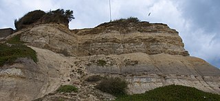
Kimmeridge Bay is a bay on the Isle of Purbeck, a peninsula on the English Channel coast in Dorset, England, close to and southeast of the village of Kimmeridge, on the Smedmore Estate. The area is renowned for its fossils, with The Etches Collection in the village of Kimmeridge displaying fossils found by Steve Etches in the area over a 30-year period. It is a popular place to access the coast for tourists. To the east are the Kimmeridge Ledges, where fossils can be found in the flat clay beds.
Igneous rocks are found in Bukit Timah, Woodlands, and Pulau Ubin island. Granite makes up the bulk of the igneous rock. Gabbro is also found in the area and is found in an area called Little Guilin, named for its resemblance to Guilin in South China. This area is in Bukit Gombak. Sedimentary rocks are found on the western part of Singapore, which is mainly made of sandstone and mudstones. It also includes the southwestern area. Metamorphic rocks are found in the northeastern part of Singapore, and also on Pulau Tekong, off the east coast of Singapore. The rocks are mainly made up of quartzite, and also make up the Sajahat Formation.

The geology of East Sussex is defined by the Weald–Artois anticline, a 60 kilometres (37 mi) wide and 100 kilometres (62 mi) long fold within which caused the arching up of the chalk into a broad dome within the middle Miocene, which has subsequently been eroded to reveal a lower Cretaceous to Upper Jurassic stratigraphy. East Sussex is best known geologically for the identification of the first dinosaur by Gideon Mantell, near Cuckfield, to the famous hoax of the Piltdown man near Uckfield.

Dorset is a county located in the middle of the south coast of England. It lies between the latitudes 50.512°N and 51.081°N and the longitudes 1.682°W and 2.958°W, and occupies an area of 2,653 km2. It spans 90 kilometres (56 mi) from east to west and 63 kilometres (39 mi) from north to south.

The geology of the Isle of Wight is dominated by sedimentary rocks of Cretaceous and Paleogene age. This sequence was affected by the late stages of the Alpine Orogeny, forming the Isle of Wight monocline, the cause of the steeply-dipping outcrops of the Chalk Group and overlying Paleogene strata seen at The Needles, Alum Bay and Whitecliff Bay.
The Thanet Formation is a geological formation found in the London Basin of southeastern England. It is of early to mid-Thanetian age and gave its name to that stratigraphic interval. It was previously known as the Thanet Beds, the Thanet Sands and the Thanet Sand Formation. It was named after the Isle of Thanet. The type sections are Herne Bay in Kent for the upper part of the formation and Pegwell Bay for the lower part. It lies unconformably on the Late Cretaceous Chalk Group. It unconformably underlies the Lambeth Group, generally the Upnor Formation but in Essex it is the Reading Formation.
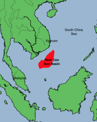
The Nam Con Son Basin formed as a rift basin during the Oligocene period. This basin is the southernmost sedimentary basin offshore of Vietnam, located within coordinates of 6°6'-9°45'N and 106°0-109°30'E in the East Vietnam Sea. It is the largest oil and gas bearing basin in Vietnam and has a number of producing fields.

The Wessex Basin is a petroleum-bearing geological area located along the southern coast of England and extending into the English Channel. The onshore part of the basin covers approximately 20,000 km2 and the area that encompasses the English Channel is of similar size. The basin is a rift basin that was created during the Permian to early Cretaceous in response to movement of the African plate relative to the Eurasian plate. In the late Cretaceous, and again in the Cenozoic, the basin was inverted as a distant effect of the Alpine orogeny. The basin is usually divided into 3 main sub-basins including the Winterborne-Kingston Trough, Channel Basin, and Vale of Pewsey Basin. The area is also rich in hydrocarbons with several offshore wells in the area. With the large interest in the hydrocarbon exploration of the area, data became more readily available, which improved the understanding of the type of inversion tectonics that characterize this basin.
The geology of Tunisia is defined by the tectonics of North Africa, with large highlands like the Atlas Mountains as well as basins such as the Tunisian Trough. Geologists have identified rock units in the country as much as a quarter-billion years old, although most units date to the Mesozoic and Cenozoic, in the past 250 million years. Tunisia has a small but active mining industry and a significant oil and natural gas sector.
The geology of Lithuania consists of ancient Proterozoic basement rock overlain by thick sequences of Paleozoic, Mesozoic and Cenozoic marine sedimentary rocks, with some oil reserves, abundant limestone, dolomite, phosphorite and glauconite. Lithuania is a country in the Baltic region of northern-eastern Europe.
