Worcester and Shrewsbury Railroad

Last updated
Worcester and Shrewsbury Railroad
Drawing of Worcester and Shrewsbury Railroad steam dummy, 1877.jpg
Drawing of a Worcester and Shrewsbury steam dummy
Overview
StatusAbandoned
Locale Worcester, Massachusetts
History
OpenedJuly 31, 1873
Converted to streetcar use1896–1900
Closed1933
Technical
Line length2.7 mi (4.3 km)
Track gauge 3 ft (914 mm) – 1873–1900
1,435 mm (4 ft 8+12 in) – 1896–1933

The Worcester and Shrewsbury Railroad was a narrow gauge railroad line in eastern Worcester, Massachusetts, United States. It opened in 1873 and was converted to a standard-gauge streetcar line in 1900.

Contents

Route

An 1874 map and profile of the railroad 1874 plan of Worcester and Shrewsbury Railroad.jpg
An 1874 map and profile of the railroad

The Worcester and Shrewsbury Railroad was 2.7 miles (4.3 km) long and ran entirely within the city of Worcester. It was originally built to 3 ft (914 mm) narrow gauge. [1] :2 The line's western terminal was near Washington Square, just north of where Union Station was built in 1875. [2] [3] It ran east and northeast along Shrewsbury Street, East Worcester Street, private right-of-way, and Albany Street. From Adams Street to Natick Street, it ran along the north side of the Boston and Albany Railroad (B&A) right-of-way. [4] [5] While the B&A ran in the aptly-named "Deep Cut", the W&S stayed at ground level above the B&A tracks. [6] From there it ran southeast into the Lakeview neighborhood, then turned north to its Lincoln Park terminus on the western shore of Lake Quinsigamond near the Boston and Worcester Turnpike. [4] [5]

Along with the terminals, the railroad had intermediate stations at Drapers (at Drapers Street), Bloomingdale (at Plantation Street) and Lakeview (at Alvarado Avenue). [7] [5] A carhouse, roundhouse, and turntable were located near the eastern terminus. [2] The line had a maximum grade of 3% – 160 feet per mile (30 m/km) – which was sustained for a full mile on the eastern half of the route. [4] [8] [7]

History

Railroad

W&S ticket from the 1880s or 1890s Worcester and Shrewsbury Railroad ticket.jpg
W&S ticket from the 1880s or 1890s

In 1872, the Massachusetts legislature permitted new railroads to be built to 3 ft (914 mm) gauge, which could be built with lower expense than standard gauge lines. [1] :2 The Worcester and Shrewsbury Railroad was chartered that year to transport passengers between downtown Worcester and Lake Quinsigamond, which was becoming a popular recreation and resort area. [9] [6] Construction began in May 1873. [10] [8] It opened as far east as Lake Signal (east of Bloomingdale) on July 31, 1873. [11] [12] The Worcester and Shrewsbury was the first narrow gauge railroad to open in Massachusetts. [1] :2 Beginning August 7, the railroad operated 20 daily round trips, with trains operating about every 45 minutes. [13] Service over the full length of the line to Lake Quinsigamond began on August 28, 1873. [14]

The line served primarily local passengers and ran a profit carrying excursion traffic to Lincoln Park on the lake shore. [1] :2 [10] During the 1874 summer season, the railroad operated every half hour from 6 am to 9 am. Fare was ten cents. [15] By 1877, the railroad was carrying 110,000–150,000 passengers annually. [7] Local businessman Horace H. Bigelow purchased the line and several attractions on Lake Quinsigamond in 1883. [6] [16] [17] By that time, the total cost to the original owners for the railroad and its rolling stock had been $60,048 (equivalent to $1,886,000in 2022). [18] Events at Lake Quinsigamond were used to promote ridership on the W&S. In August 1886, the company offered $500 to rower Ned Hanlan to break a single scull record. [19] [20] By 1890, the railroad was scheduled for 18 daily round trips in the winter and 22 in the summer, with additional trips operated most days. [6]

The W&S was originally intended to continue east from Lake Quinsigamond into Shrewsbury. [8] [11] In 1875, the railroad conducted surveys for a 16+12-mile (26.6 km) extension past Shrewsbury to Marlborough via Northborough. None of the three towns had direct rail service to Worcester at that time. [21] [6] In 1882 and 1885, proposals to fund an extension were declined at Shrewsbury town meetings. [6] In September 1887, the W&S tested an electric railcar over its line. [22] Plans for an extension were revived in 1891; in June 1892, the legislature authorized the W&S to cross the Lake Quinsigamond causeway provided the line was completed to Marlborough within three years. [23] [24] By 1893, the railroad had plans to electrify its line along with building the Marlborough extension. [25]

Streetcar conversion

A Boston and Worcester Street Railway streetcar on the line in the early 20th century Haven's Curve postcard.jpg
A Boston and Worcester Street Railway streetcar on the line in the early 20th century

The Worcester Consolidated Street Railway, which operated an extensive streetcar system in Worcester and surrounding towns, received permission from the state legislature in June 1896 to lease the W&S and the Worcester and Shrewsbury Street Railway (an unrelated streetcar company). [26] The lease of the W&S took effect on July 1, 1896, with an annual rental of $3,750 (equivalent to $132,000in 2022). In its final 12 months of independent operations, the line had carried 575,512 passengers and earned a net profit of $4,253 (equivalent to $150,000in 2022). [27] The Consolidated had also leased Lincoln Park by this time. [28]

The Consolidated soon added an electrified standard gauge track on the north side of the W&S track between Bloomingdale and Lincoln Park. This track connected to the existing Consolidated streetcar line on Shrewsbury Street and Belmont Street near Liscomb Street and at Lincoln Park, forming a loop line know as the "Lake line" (also "Lake View line"). [29] [30] [31] After the new streetcar track entered service, steam-powered service on the W&S track operated only intermittently, such when there was high ridership to the lake or events at the nearby Worcester Oval, or when the streetcar line was blocked. [32] [33] Despite this, eastward extension of the W&S was again considered in 1898. [34]

The Boston and Worcester Street Railway (B&W), an interurban line between its namesake cities, began operation on July 1, 1903. [35] :29 All B&W service initially used the Lake View line to enter and leave Worcester. [35] :10 The B&W introduced limited-stop service in 1909. By 1911, eastbound limited cars exited the city on the Shrewsbury/Belmont line, which saved four minutes compared to the longer Lake View line. [35] :35 Beginning on October 12, 1925, all B&W cars used the Shrewsbury/Belmont route. [35] :36

The W&S and the Worcester and Shrewsbury Street Railway were consolidated into the Consolidated on March 29, 1929. [36] The Lake View line was replaced with buses in 1933, ending rail service on the former Worcester and Shrewsbury. [37] :6 [38]

Rolling stock

The W&S began operation with a single 22-horsepower steam dummy locomotive and two passenger cars. The dummy and one car were made by E. Remington and Sons in Ilion, New York, at a cost of $3,500 (equivalent to $85,000in 2022). The other car cost $500 (equivalent to $12,000in 2022) and was made by J.M. Jones and Co. of West Troy, New York. [11] [8] The W&S was locally known as the "dummy" after the steam dummy. [7] By 1875, the W&S owned three locomotives, four passenger cars, four cars for freight or other purposes, and one snowplow. [9] At the time of its lease by the Consolidated, the W&S owned four locomotives, eleven passenger cars, and four freight cars. [27]

Related Research Articles

<span class="mw-page-title-main">Lake Quinsigamond</span> Lake in Central Massachusetts

Lake Quinsigamond is a body of water situated between the city of Worcester and the town of Shrewsbury in Worcester County, Massachusetts, United States. It is 4 miles (6.4 km) long, between 50 and 85 feet deep, and has a surface area of approximately 772 acres (3.12 km2). Lake Quinsigamond hosts 8 islands with the majority owned by private citizens. Two islands are connected to land via bridge. The largest island, Drake Island, is still state owned. Water from the lake empties into the Quinsigamond River in the Blackstone Valley.

<span class="mw-page-title-main">Boston, Revere Beach and Lynn Railroad</span>

The Boston, Revere Beach and Lynn Railroad was a 3 ft narrow-gauge passenger-carrying shortline railroad between East Boston and Lynn, Massachusetts, from 1875 to 1940. Part of the railroad's right of way now forms the outer section of the Massachusetts Bay Transportation Authority's Blue Line rapid transit service.

<span class="mw-page-title-main">Boston and Albany Railroad</span> American railroad line (1867-1961)

The Boston and Albany Railroad was a railroad connecting Boston, Massachusetts to Albany, New York, later becoming part of the New York Central Railroad system, Conrail, and CSX Transportation. The line is currently used by CSX for freight. Passenger service is provided on the line by Amtrak, as part of their Lake Shore Limited service, and by the MBTA Commuter Rail system, which owns the section east of Worcester and operates it as its Framingham/Worcester Line.

<span class="mw-page-title-main">West End Street Railway</span> Former streetcar company serving the Boston metro area, Massachusetts, USA (1887-1922)

The West End Street Railway was a streetcar company that operated in Boston, Massachusetts and several surrounding communities in the late nineteenth century.

The Middlesex and Boston Street Railway (M&B) was a streetcar and later bus company in the area west of Boston. Streetcars last ran in 1930, and in 1972, the company's operations were merged into the Massachusetts Bay Transportation Authority (MBTA).

<span class="mw-page-title-main">Boston and Worcester Street Railway</span>

Boston and Worcester Electric Companies (B&W) was a holding company for several streetcar companies between Boston and Worcester, Massachusetts. The main line, built by the Boston and Worcester Street Railway, was an interurban streetcar line partly on the old Boston and Worcester Turnpike and partly on private right-of-way. Long after the line was converted to buses, Boston and Worcester Lines took over operations, and sold the franchises to various other bus companies.

<span class="mw-page-title-main">New York and New England Railroad</span> Defunct railroad in southern New England

The New York and New England Railroad (NY&NE) was a railroad connecting southern New York State with Hartford, Connecticut; Providence, Rhode Island; and Boston, Massachusetts. It operated under that name from 1873 to 1893. Prior to 1873 it was known as the Boston, Hartford and Erie Railroad, which had been formed from several smaller railroads that dated back to 1846. After a bankruptcy in 1893, the NY&NE was reorganized and briefly operated as the New England Railroad before being leased to the competing New York, New Haven and Hartford Railroad in 1898.

<span class="mw-page-title-main">Green Line E branch</span> Light rail line

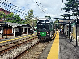
The E branch is a light rail line in Boston, Cambridge, Medford, and Somerville, Massachusetts, operating as part of the Massachusetts Bay Transportation Authority (MBTA) Green Line. The line runs in mixed traffic on South Huntington Avenue and Huntington Avenue between Heath Street and Brigham Circle, in the median of Huntington Avenue to Northeastern University, then into the Huntington Avenue subway. The line merges into the Boylston Street subway just west of Copley, running to North Station via the Tremont Street subway. It then follows the Lechmere Viaduct to Lechmere, then the Medford Branch to Medford/​Tufts. As of February 2023, service operates on eight-minute headways at weekday peak hours and eight to nine-minute headways at other times, using 13 to 17 trains.

<span class="mw-page-title-main">Green Line B branch</span> Light rail line in Boston, Massachusetts

The B branch, also called the Commonwealth Avenue branch or Boston College branch, is a branch of the MBTA Green Line light rail system which operates on Commonwealth Avenue west of downtown Boston, Massachusetts. One of four branches of the Green Line, the B branch runs from Boston College station down the median of Commonwealth Avenue to Blandford Street. There, it enters Blandford Street portal into Kenmore station, where it merges with the C and D branches. The combined services run into the Boylston Street subway and Tremont Street subway to downtown Boston. B branch service has terminated at Government Center since October 2021. Unlike the other branches, the B branch runs solely through the city limits of Boston. The Green Line Rivalry between Boston College and Boston University is named in reference to the B branch, which runs to both universities.

<span class="mw-page-title-main">Highland branch</span> Suburban railway line in Boston, Massachusetts

The Highland branch, also known as the Newton Highlands branch, was a suburban railway line in Boston, Massachusetts. It was opened by the Boston and Albany Railroad in 1886 to serve the growing community of Newton, Massachusetts. The line was closed in 1958 and sold to the Metropolitan Transit Authority (MTA), the predecessor of the current Massachusetts Bay Transportation Authority (MBTA), which reopened it in 1959 as a light rail line, now known as the D branch of the Green Line.

<span class="mw-page-title-main">Brookline Village station</span> Light rail station in Brookline, Massachusetts, US

Brookline Village station is a light rail station on the MBTA Green Line D branch, located in the Brookline Village neighborhood of Brookline, Massachusetts, United States. It was originally a commuter rail station on the Boston and Albany Railroad's Highland branch; it closed with the rest of the line in 1958 and reopened on July 4, 1959 as a light rail station. With 3,230 daily boardings, it is the third-busiest surface station on the D branch and the sixth-busiest surface station overall. Brookline Village station has raised platforms for accessibility with low-floor light rail vehicles.

<span class="mw-page-title-main">Suffolk Downs station</span> Rapid transit station in East Boston, Massachusetts

Suffolk Downs station is a rapid transit station on the Massachusetts Bay Transportation Authority (MBTA) Blue Line, located on the east side of Orient Heights in East Boston, Massachusetts, United States. It is named for the now-defunct Suffolk Downs racetrack, located just to the north. Suffolk Downs station has two side platforms, with a footbridge structure of brick, concrete, and steel connecting them. The station is accessible. With just 521 daily boardings in FY 2019, Suffolk Downs is the least-used fare-controlled station on the MBTA subway system.

The Lexington and West Cambridge Railroad was a railroad company chartered in 1845 and opened in 1846 that operated in eastern Massachusetts. It and its successors provided passenger service until 1977 and freight service until 1980 or early 1981.

<span class="mw-page-title-main">Railroad history of Portland, Maine</span>

The railroad history of Portland, Maine, began in 1842 with the arrival of the Portland, Saco & Portsmouth Railway (PS&P). Most of the rail activity in Portland revolved around agricultural goods bound for export and import freight from Europe. Yet Maine's largest city also enjoyed 125 years of continuous passenger rail service, from 1842 until 1967, and Amtrak began serving the city in 2001. For most of Portland's history, passenger train schedules were designed with intercity travel rather than daily commuting in mind; passenger activities were mostly confined to intercity travel from Portland to Boston, Montreal, Nova Scotia, and points west.

<span class="mw-page-title-main">Erastus Wells</span> American politician

Erastus Wells was a 19th-century politician and businessman from Missouri. Wells was born in Jefferson County, New York, and was the only son of Otis Wells, a descendant of Hugh Welles, an early colonist of Wethersfield, Connecticut. Otis Wells was a farmer and died when Erastus was only fourteen. Erastus was the grandson of Ethelinda Otis and a relation of John Otis, who helped found the town of Hingham, Massachusetts in 1635. Other notable relatives include James Otis, a successful lawyer, Harrison Gray Otis, a statesman and orator, Samuel A. Otis, one of the framers of the constitution of Massachusetts, and George Otis, a clergyman and author.

<span class="mw-page-title-main">Ayer station</span> Railway station in Ayer, Massachusetts, US

Ayer station is an MBTA Commuter Rail station located off Main Street in the Ayer Main Street Historic District of Ayer, Massachusetts. It serves the Fitchburg Line. There are three tracks through the station, two of which are served by a pair of low-level side platforms, which are not accessible. There is a shelter on the inbound platform.

<span class="mw-page-title-main">Grafton station (MBTA)</span> Railway station in Grafton, Massachusetts, US

Grafton station is an MBTA Commuter Rail station in the North Grafton village of Grafton, Massachusetts, served by the Framingham/Worcester Line. The station is fully accessible, with mini-high platforms serving both of the line's two tracks.

<span class="mw-page-title-main">Framingham station</span> MBTA and Amtrak railroad station in Framingham, Massachusetts.

Framingham station is a historic Boston and Albany Railroad station located in downtown Framingham, Massachusetts. Designed by noted American architect H. H. Richardson, it was one of the last of the railroad stations he designed in the northeastern United States to be built. The station, built in 1884–85, served as a major stop on the B&A Main Line as well as a hub for branch lines to Milford, Mansfield, Fitchburg, and Lowell. After years of deterioration, the station was listed on the National Register of Historic Places in 1975 as the Framingham Railroad Station, and restored a decade later.

<span class="mw-page-title-main">Babcock Street station</span> Light rail station in Boston, Massachusetts, US

Babcock Street station is a light rail stop on the Massachusetts Bay Transportation Authority (MBTA) Green Line B branch, located in the median of Commonwealth Avenue in the west part of the Boston University campus. The accessible station has two side platforms serving the line's two tracks, with access at Babcock Street and Pleasant Street.

<span class="mw-page-title-main">Warwick Railway</span> Railroad in Rhode Island, United States

The Warwick Railway was a railroad in Rhode Island, United States. It was originally chartered in 1873 under the name Warwick Railroad, with a route connecting Cranston to Oakland Beach, eight miles (13 km) away. Opened in 1875, the company survived until 1879 when it declared bankruptcy and shut down; it was resurrected in 1880 as the Rhode Island Central Railroad under New York, Providence and Boston Railroad (NYP&B) ownership and extended by two miles (3.2 km) in length. Following the New York, New Haven and Hartford Railroad's purchase of the NYP&B in 1892, operations continued with steam power until the Rhode Island Central Railroad's 1899 consolidation with the Rhode Island Suburban Railway, at which point the line was electrified and trolleys replaced steam locomotives. Control subsequently passed to the United Electric Railways in 1921. Passenger trolley service was discontinued in 1935, but freight service continued; the following year, the line was cut back from its 10 mile maximum length to just two miles (3.2 km).

References

  1. 1 2 3 4 Humphrey, Thomas J.; Clark, Norton D. (1986). Boston's Commuter Rail: Second Section. Boston Street Railway Association. ISBN   9780938315025.
  2. 1 2 Atlas of the city of Worcester, Massachusetts (Map). 1:1,800, 1:3,600. L.J. Richards & Co. 1896. Plate 18, Plate 19.
  3. "Plate 43" (Map). Sanborn Fire Insurance Map from Worcester, Worcester County, Massachusetts. Sanborn Map Company. 1892. hdl:loc.gmd/g3764wm.g038971892.
  4. 1 2 3 Wheeler, Daniel Merrick (June 1874). Plan of Worcester and Shrewsbury R.R. (Map). 1:2,400 via Wikimedia Commons.
  5. 1 2 3 Atlas of the city of Worcester, Massachusetts (Map). 1:2,400, 1:4,800. L.J. Richards & Co. 1886. Plate 14, Plate 15.
  6. 1 2 3 4 5 6 Perna, Michael P. (1998). Remembering Lake Quinsigamond: From Steamboats to White City. Chandler House Press. pp. 71–73. ISBN   9781886284029.
  7. 1 2 3 4 "The Dummy Railroad". Pleasure Resorts in Worcester County, and how to Reach Them: Containing Descriptive Sketch of Lake Quinsigamond and Its Environs, with Other Popular Places for the Summer Excursionist. Edward Rice Fiske. 1877. pp. 29–33.
  8. 1 2 3 4 Fleming, Howard (1875). Narrow Gauge Railways in America. p. 72.
  9. 1 2 Poor's Manual of Railroads. Vol. 9. H.V. & H.W. Poor. 1876. pp. 154–155.
  10. 1 2 Karr, Ronald Dale (2017). The Rail Lines of Southern New England (2 ed.). Branch Line Press. p. 428. ISBN   9780942147124.
  11. 1 2 3 "Railroad Matters". The Boston Globe. July 26, 1873. p. 5 via Newspapers.com.
  12. "The Dummy Railroad". Worcester Daily Spy. Vol. 28, no. 181. August 1, 1873. p. 1.
  13. "For Lake Quinsigamond [advertisement]". Worcester Daily Press. Vol. 1, no. 123. August 22, 1873. p. 3.
  14. "Various Matters". Worcester Daily Press. Vol. 1, no. 128. August 28, 1873. p. 2.
  15. "Worcester and Shrewsbury Railroad [advertisement]". Worcester Daily Spy. Vol. 29, no. 111. May 11, 1874. p. 3.
  16. "Our Business Pioneers". The Boston Globe. March 31, 1916. p. 14 via Newspapers.com.
  17. "Massachusetts". Boston Evening Transcript. June 15, 1883. p. 2 via Newspapers.com.
  18. "Worcester & Shrewsbury Railroad". The Boston Globe. October 27, 1883. p. 5 via Newspapers.com.
  19. "Hanlan Will Try It". The Fall River Daily Herald. August 3, 1886. p. 2 via Newspapers.com.
  20. "Hanlan's Feat". The Boston Globe. August 13, 1886. p. 3 via Newspapers.com.
  21. "Marlboro". The Boston Globe. April 24, 1875. p. 2 via Newspapers.com.
  22. "Massachusetts". Boston Evening Transcript. September 15, 1887. p. 2 via Newspapers.com.
  23. "Railroad Wants to Extend its Line". Boston Evening Transcript. November 27, 1891. p. 1 via Newspapers.com.
  24. "Chapter 364: An Act to Authorize the Worcester and Shrewsbury Railroad Company to Extend its Tracks Across Lake Quinsigamond". Acts and resolves passed by the General Court of Massachusetts in the Year 1892. Massachusetts General Court. 1893. pp. 379–380.
  25. "Newsy News". Transcript-Telegram. January 9, 1893. p. 3 via Newspapers.com.
  26. "Chapter 511: An Act To Authorize The Worcester And Shrewsbury Street Railway Company And The Worcester And Shrewsbury Railroad Company To Lease Their Property To The Worcester Consolidated Street Railway Company". Acts and resolves passed by the General Court of Massachusetts in the Year 1896. Massachusetts General Court. 1897. pp. 513–514.
  27. 1 2 Poor's Manual of Railroads. Vol. 30. H.V. & H.W. Poor. 1897. p. 25.
  28. "Down by the Lake". Worcester Morning Daily Spy. April 12, 1897. p. 3.
  29. "General News". Electricity. Vol. 11, no. 13. October 7, 1896. p. 203.
  30. "Washout on Lake Line". Worcester Morning Daily Spy. April 10, 1897. p. 3.
  31. "City of Worcester" (Map). New topographical atlas of the county of Worcester, Massachusetts. L.J. Richards & Co. 1898. Plate 2.
  32. "Intercollegiate Meet". Worcester Morning Daily Spy. May 11, 1897. p. 10.
  33. "Worst Is Over". Worcester Morning Daily Spy. February 5, 1898. p. 1.
  34. "Mr. Bigelow's Road". Worcester Morning Daily Spy. February 26, 1898. p. 5.
  35. 1 2 3 4 Cummings, O.R. (1975). Trolleys Along The Turnpike. Boston Street Railway Association.
  36. Moody's Public Utilities. 1935. p. 1361. On Mar. 29, 1929, Worcester and Shrewsbury Railroad Co. and Worcester and Shrewsbury Street Railway Co. were consolidated with the Worcester Consolidated Street Railway Co. by purchase of all franchises and property of the former two companies for $56,700 Worcester Consolidated Street Railway Co. common stock.
  37. Carlson, Stephen P.; Harding, Thomas W. (1985). Worcester Trolleys Remembered. Worcester Regional Transit Authority.
  38. "Patrons Must Walk as Result of Ruling". The Boston Globe. June 8, 1934. p. 28 via Newspapers.com.

Commons-logo.svg Media related to Worcester and Shrewsbury Railroad at Wikimedia Commons