Boston and Worcester Street Railway

Last updated
1900s postcard of two Boston and Worcester Street Railway streetcars in South Framingham. At left is an open car to Hudson via Marlborough; at right is a closed car to Boston. B&W streetcars at South Framingham postcard.jpg
1900s postcard of two Boston and Worcester Street Railway streetcars in South Framingham. At left is an open car to Hudson via Marlborough; at right is a closed car to Boston.

Boston and Worcester Electric Companies (B&W) was a holding company for several streetcar companies between Boston and Worcester, Massachusetts. The main line, built by the Boston and Worcester Street Railway, was an interurban streetcar line partly on the old Boston and Worcester Turnpike (now Route 9) and partly on private right-of-way. Long after the line was converted to buses, Boston and Worcester Lines took over operations, and sold the franchises to various other bus companies.

Contents

In Newton, the B&W was granted a franchise in exchange for constructing a 90-foot (27 m) wide boulevard, of which it ran down the median. The B&W also carried freight.

History

The B&W's Framingham Junction waiting room on an early postcard Framingham Junction station postcard.jpg
The B&W's Framingham Junction waiting room on an early postcard

The Boston and Worcester Street Railway was chartered November 16, 1901. Service between Boston and Framingham Junction began on May 5, 1903. [1] [2] (The line operated over the Boston Elevated Railway in Brookline and Boston; these trackage rights had been granted in December 1900 after a brief controversy. [3] ) Service between Worcester and Chestnut Hill began on July 1, 1903; Worcester–Boston service began five days later. [4] Running time between the terminal was two hours and fifteen minutes; this was slower than Boston and Albany Railroad trains, but the B&W cost 40 cents versus the railroad's one-dollar fare. Service operated every half-hour, with short turn cars providing fifteen-minute frequency east of Framingham. [5]

Boston and Worcester Electric Companies was incorporated December 29, 1902 to serve as a holding company. The B&W arranged control of several connecting roads in 1899 and purchased them in 1903–04: [6] [7]

The B&W opened a short branch to Natick Center in 1909. [8]

In 1925–26, the B&W attempted to replace its entire service with buses, but was rebuffed by Brookline. [9] [10] However, the Framingham–Framingham Centre and Framingham Junction–Saxonville routes were replaced by buses on June 13, 1925. On July 3, 1926, the B&W began operating a Boston–Worcester bus line that followed the turnpike west of Shrewsbury, and the Post Road east of Northborough. The Hudson branch was replaced by buses in April 1928, followed by the Natick branch on October 15. Framingham Junction–Framingham service ended in September 1930. [11] The line was cut back to Framingham on January 15, 1931, as paving of the turnpike progressed eastward, with buses replacing the western half. [8] [11] On June 11, 1932, the eastern half of the line was replaced with buses as well. [11]

Rail trail

The Boston Worcester Air Line Trail is a proposed multi-use rail trail between Framingham and Worcester that would reuse much of the abandoned B&W right-of-way between Shrewsbury and Southborough. Planning for the trail was initiated by Shrewsbury, Westborough, and Northborough around 2013. [12] Several portions of the right-of-way in Westborough are in use as existing trails, including between Lyman Street and East Main Street and within the Walkup and Robinson Memorial Reservation. A feasibility study for the Westborough section of the trail was released in 2021. [13] In June 2023, the town was awarded $440,000 in state funds for design of the 1.7-mile (2.7 km) section between Otis Street and Park Street. [14] Not on the former B&W alignment, this section would connect the trail with Westborough station. [13]

Routes

1904 map of the Boston and Worcester Street Railway 1904 Boston and Worcester Street Railway bird's eye view map.jpg
1904 map of the Boston and Worcester Street Railway

Main line

The main line ran along the old Boston and Worcester Turnpike (now Route 9) for most of its length. It used tracks of the Worcester Consolidated Street Railway between the City Hall terminal and Lake Junction in Shrewsbury (slightly east of the Lake Quinsigamond causeway). Service initially used the Consolidated's Lake View line (the former Worcester and Shrewsbury Railroad), which ran partially on private right-of-way west of the lake. Around 1911, some limited service began using a different Consolidated line on Shrewsbury Street and Belmont Street; all service began using that route in 1925. [15] :35–36

Between Lake Junction and Whites Corner in Southborough, the B&W used a private right-of-way roughly paralleling the Turnpike. East of Whites Corner, it followed the turnpike to Chestnut Hill on the Newton/Brookline border. [15] :9–12 It used Boston Elevated Railway (BERy) tracks along the turnpike and Huntington Avenue into Boston. For most of its history, the B&W used BERy tracks on Massachusetts Avenue and Columbus Avenue to reach its eastern terminal at Park Square in Boston. [15] :10 In the late 1920s, the BERY abandoned most of its Columbus Avenue tracks; B&W cars instead continued on Huntington Avenue to Copley Square, then followed Boylston Street, Berkeley Street, and Columbus Avenue to Park Square. [15] :36

Branches

Former right-of-way of the branch to Natick, photographed in 2016 Boston and Worcester Street Railway Natick Branch ROW (2), April 2016.JPG
Former right-of-way of the branch to Natick, photographed in 2016

The B&W also operated several branch line services. The Natick branch split from the main line at Natick Junction, east of Walnut Street. It followed a private right-of-way to Highland Street, then ran on Middle Street, Sawin Street, North Avenue, Washington Street, and Park Street to Natick Common in downtown Natick, Massachusetts. Service ran between Natick Common and Chestnut Hill from 1908 to around 1917, with some through service to Park Square in the mid-1910s. From around 1917 to 1928, it operated as a shuttle service between Natick Common and Natick Junction. [15] :42

Tracks ran between South Framingham and the main line at Framingham Center via Union Avenue and Main Street, and between South Framingham and Saxonville via Concord Street (intersecting the main line at Framingham Junction). Local service ran on both these lines, and South Framingham–Boston service used the Saxonville line between South Framingham and Framingham Junction. [15] :40

A long branch ran between Whites Corner and Hudson via Southborough and Marlborough. Hudson service ran to Whites Corner, South Framingham, Chestnut Hill, and Park Square at various times. A short crosstown line also ran within Marlborough. [15] :46

Related Research Articles

<span class="mw-page-title-main">Marlborough, Massachusetts</span> City in Massachusetts, United States

Marlborough is a city in Middlesex County, Massachusetts, United States. The population was 41,793 at the 2020 census. Marlborough became a prosperous industrial town in the 19th century and made the transition to high technology industry in the late 20th century after the construction of the Massachusetts Turnpike.

<span class="mw-page-title-main">Southborough, Massachusetts</span> Town in Massachusetts, United States

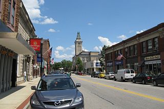
Southborough is a town in Worcester County, Massachusetts, United States. It incorporates the villages of Cordaville, Fayville, and Southville. Its name is often informally shortened to Southboro, a usage seen on many area signs and maps, though officially rejected by town ordinance. At the 2020 census, its population was 10,450 in 3,542 households.

<span class="mw-page-title-main">Framingham, Massachusetts</span> City in Massachusetts, US

Framingham is a city in the Commonwealth of Massachusetts in the United States. Incorporated in 1700, it's located in Middlesex County and the MetroWest subregion of the Greater Boston metropolitan area. The city proper covers 25 square miles (65 km2) with a population of 72,362 in 2020, making it the 14th most populous municipality in Massachusetts. Residents voted in favor of adopting a charter to transition from a representative town meeting system to a mayor–council government in April 2017, and the municipality transitioned to city status on January 1, 2018. Before it transitioned, it had been the largest town by population in Massachusetts.

<span class="mw-page-title-main">Massachusetts Route 9</span> East-west state highway in Massachusetts, US

Route 9 is a 135.310-mile-long (217.760 km) major east–west state highway in Massachusetts, United States. Along with U.S. Route 20, Route 2, and Interstate 90, Route 9 is one of the major east–west routes of Massachusetts. The western terminus is near the center of the city of Pittsfield. After winding through the small towns along the passes of the Berkshire Mountains, it crosses the college towns of the Pioneer Valley and then south of the Quabbin Reservoir and the rural areas of western Worcester County. Entering the city of Worcester from the southwest corner of the city, it passes through the center of the city and forms the major commercial thoroughfare through the MetroWest suburbs of Boston, parallel to the Massachusetts Turnpike. Crossing the Route 128 freeway circling Boston, it passes through the inner suburbs of Newton and Brookline along Boylston Street, and enters Boston on Huntington Avenue, before reaching its eastern terminus at Copley Square.

<span class="mw-page-title-main">MetroWest</span> Region west of Boston and east of Worcester, in the U.S. state of Massachusetts

MetroWest is a cluster of cities and towns lying west of Boston and east of Worcester, in the U.S. state of Massachusetts. The name was coined in the 1980s by a local newspaper.

<span class="mw-page-title-main">Boston and Albany Railroad</span> American railroad line (1867-1961)

The Boston and Albany Railroad was a railroad connecting Boston, Massachusetts to Albany, New York, later becoming part of the New York Central Railroad system, Conrail, and CSX Transportation. The line is currently used by CSX for freight. Passenger service is provided on the line by Amtrak, as part of their Lake Shore Limited service, and by the MBTA Commuter Rail system, which owns the section east of Worcester and operates it as its Framingham/Worcester Line.

<span class="mw-page-title-main">Green Line B branch</span> Light rail line in Boston, Massachusetts

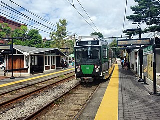
The B branch, also called the Commonwealth Avenue branch or Boston College branch, is a branch of the MBTA Green Line light rail system which operates on Commonwealth Avenue west of downtown Boston, Massachusetts. One of four branches of the Green Line, the B branch runs from Boston College station down the median of Commonwealth Avenue to Blandford Street. There, it enters Blandford Street portal into Kenmore station, where it merges with the C and D branches. The combined services run into the Boylston Street subway and Tremont Street subway to downtown Boston. B branch service has terminated at Government Center since October 2021. Unlike the other branches, the B branch runs solely through the city limits of Boston. The Green Line Rivalry between Boston College and Boston University is named in reference to the B branch, which runs to both universities.

<span class="mw-page-title-main">Framingham/Worcester Line</span> MBTA commuter railroad line

The Framingham/Worcester Line of the MBTA Commuter Rail system runs west from Boston, Massachusetts to Worcester, Massachusetts through the MetroWest region, serving 17 station stops in Boston, Newton, Wellesley, Natick, Framingham, Ashland, Southborough, Westborough, Grafton, and Worcester. It is the third longest and third busiest line in the MBTA Commuter Rail system. Service on the line is a mix of local and express trains serving Worcester plus short-turn Framingham locals.

<span class="mw-page-title-main">Massachusetts Route 30</span> East-west state highway in Massachusetts, US

Route 30 is a 36.3817-mile-long (58.5507 km) east–west arterial route, connecting Grafton with Packard's Corner in Boston. Route 30 runs roughly parallel to the Massachusetts Turnpike and Route 9, but unlike those two larger highways, takes a more meandering path from town to town. Between Boston and the Charles River it is known as Commonwealth Avenue, along most of this route is part of the course of the Boston Marathon.

<span class="mw-page-title-main">Brookline Village station</span> Light rail station in Brookline, Massachusetts, US

Brookline Village station is a light rail station on the MBTA Green Line D branch, located in the Brookline Village neighborhood of Brookline, Massachusetts, United States. It was originally a commuter rail station on the Boston and Albany Railroad's Highland branch; it closed with the rest of the line in 1958 and reopened on July 4, 1959 as a light rail station. With 3,230 daily boardings, it is the third-busiest surface station on the D branch and the sixth-busiest surface station overall. Brookline Village station has raised platforms for accessibility with low-floor light rail vehicles.

<span class="mw-page-title-main">Natick Center station</span> Train station in Natick, Massachusetts, US

Natick Center station is an MBTA Commuter Rail station in Natick, Massachusetts served by the Framingham/Worcester Line. The station, located below grade in a wide cut adjacent to North Main Street, has two side platforms serving the line's two tracks. The second-busiest non-accessible station on the system, it is undergoing a major accessibility renovation and modernization from 2020 to 2024.

<span class="mw-page-title-main">Lansdowne station (MBTA)</span> Railway station in Boston, Massachusetts, US

Lansdowne station is an MBTA Commuter Rail station in Boston, Massachusetts. It serves the Framingham/Worcester Line. Lansdowne is located next to the Massachusetts Turnpike in the Fenway–Kenmore neighborhood near Kenmore Square, below grade between Beacon Street and Brookline Avenue.

<span class="mw-page-title-main">Ashland station (MBTA)</span> Railway station in Ashland, Massachusetts, US

Ashland station is an MBTA Commuter Rail station in Ashland, Massachusetts. It serves the Framingham/Worcester Line. It has a long driveway leading from the south parking lot to the intersection of West Union Street and Voyagers Lane. Like the other stations on the line west of Framingham, Ashland serves as a park-and-ride station with 678 parking spots.

<span class="mw-page-title-main">Southborough station (MBTA)</span> Railroad station in Southborough, Massachusetts

Southborough station is a commuter rail station on the MBTA Commuter Rail Framingham/Worcester Line, located near the intersection of Cordaville Street and River Street in the Cordaville section of Southborough, Massachusetts. The parking area is located off River Street adjacent to the inbound platform. Passengers use ramps and stairways to access the sidewalk along River Street to cross under the tracks.

<span class="mw-page-title-main">Westborough station</span> Train station in Westborough, Massachusetts, US

Westborough station is an MBTA Commuter Rail station in Westborough, Massachusetts. It serves the Framingham/Worcester Line. It is located off Smith Parkway, west of the Westborough town center. The station consists of two side platforms serving the line's two tracks. Each side has a small mini-high platform for accessibility; an overhead ramp structure connects the two platforms.

<span class="mw-page-title-main">Grafton station (MBTA)</span> Railway station in Grafton, Massachusetts, US

Grafton station is an MBTA Commuter Rail station in the North Grafton village of Grafton, Massachusetts, served by the Framingham/Worcester Line. The station is fully accessible, with mini-high platforms serving both of the line's two tracks.

<span class="mw-page-title-main">Framingham station</span> MBTA and Amtrak railroad station in Framingham, Massachusetts.

Framingham station is a historic Boston and Albany Railroad station located in downtown Framingham, Massachusetts. Designed by noted American architect H. H. Richardson, it was one of the last of the railroad stations he designed in the northeastern United States to be built. The station, built in 1884–85, served as a major stop on the B&A Main Line as well as a hub for branch lines to Milford, Mansfield, Fitchburg, and Lowell. After years of deterioration, the station was listed on the National Register of Historic Places in 1975 as the Framingham Railroad Station, and restored a decade later.

<span class="mw-page-title-main">Westborough, Massachusetts</span> Town in Worcester County, Massachusetts, US

Westborough is a town in Worcester County, Massachusetts, United States. The population was 21,567 at the 2020 Census, in over 7,000 households. Incorporated in 1717, the town is governed under the New England open town meeting system, headed by a five-member elected Board of Selectmen whose duties include licensing, appointing various administrative positions, and calling a town meeting of citizens annually or whenever the need arises.

<span class="mw-page-title-main">Ipswich Street line</span> Former streetcar line in Boston and Brookline, Massachusetts

The Ipswich Street line was a streetcar line in Boston and Brookline, Massachusetts. The line ran on Boylston Street and Ipswich Street in the Fenway–Kenmore neighborhood, and on Brookline Avenue through what is now the Longwood Medical Area to Brookline Village.

<span class="mw-page-title-main">Worcester and Shrewsbury Railroad</span>

The Worcester and Shrewsbury Railroad was a narrow gauge railroad line in eastern Worcester, Massachusetts, United States. It opened in 1873 and was converted to a standard-gauge streetcar line in 1900.

References

  1. Carlson, Stephen P.; Harding, Thomas W. (1990). From Boston to the Berkshires: a pictorial review of electric transportation in Massachusetts. Boston Street Railway Association. p. 123. ISBN   093831503X.
  2. "Stagnation Still Rules the Market". Boston Post. May 2, 1903. p. 10 via Newspapers.com. Open Access logo PLoS transparent.svg
  3. "Wrangle Ends". Boston Globe. December 15, 1900. p. 11 via Newspapers.com. Open Access logo PLoS transparent.svg
  4. "Cars Running". Boston Globe. July 1, 1903. p. 6 via Newspapers.com. Open Access logo PLoS transparent.svg
  5. "Between June 15 and 20". Boston Globe. June 1, 1903. p. 8 via Newspapers.com. Open Access logo PLoS transparent.svg
  6. "Gets the Marlboro Lines". Boston Evening Transcript. November 13, 1899. p. 6 via Google News.
  7. "Two Roads Absorbed". Boston Globe. November 7, 1903. p. 3 via Newspapers.com. Open Access logo PLoS transparent.svg
  8. 1 2 Hilton, George W.; Due, John F. (2000). The Electric Interurban Railways in America. Stanford University Press. pp. 320–322. ISBN   0-8047-4014-3.
  9. "Bus Franchise for Boston & Worcester". Boston Globe. September 15, 1925. p. 23 via Newspapers.com. Open Access logo PLoS transparent.svg
  10. "Brookline Grants Elevated Bus Line". Boston Globe. February 24, 1926. p. 17 via Newspapers.com. Open Access logo PLoS transparent.svg
  11. 1 2 3 Humphrey, Thomas J. (August 2020). "Origin and Development of the Fixed-Route Local Bus Transportation Network in the Cities and Towns of the Massachusetts Bay Transportation Authority District as of December 31, 1973: Revised Edition" (PDF). NETransit. pp. 154–159.
  12. "Boston Worcester Air Line Bike Trail Route Planning: Shrewsbury–Northborough–Westborough" (PDF). Central Massachusetts Regional Planning Commission. 2013. Archived from the original (PDF) on January 3, 2016.
  13. 1 2 WDA Design Group (October 2021). BWALT Shared-Use Path Feasibility Study (Report). Town of Westborough.
  14. McNamara, Neil (June 15, 2023). "Westborough BWALT Trail Gets $440K State Award For Extension". Westborough Patch. Archived from the original on February 20, 2024.
  15. 1 2 3 4 5 6 7 Cummings, O.R. (1975). Trolleys Along The Turnpike. Boston Street Railway Association.
Template:Attached KML/Boston and Worcester Street Railway
KML is from Wikidata

Commons-logo.svg Media related to Boston and Worcester Street Railway at Wikimedia Commons