
Redgrave is a village and civil parish in Suffolk, England, just south of the River Waveney that here forms the county boundary with Norfolk. The village is about 4+1⁄2 miles (7 km) west of the town of Diss. The 2011 Census recorded the parish population as 459.

Dennington is a village and civil parish in the English county of Suffolk. It is 2 miles (3.2 km) north of Framlingham and 15 miles (24 km) north-east of Ipswich in the east of the county. It lies along the A1120 road around 8 miles (13 km) west of the road's junction with the main A12 road in Yoxford.

Longworth is a village and civil parish in the Vale of White Horse, England. Historically within the north-west projection of Berkshire, boundary changes transferred it to Oxfordshire in 1974. The village is between Faringdon, 7 miles (11 km) to the west, and Oxford, 9 miles (14 km) to the northeast. The 2021 Census recorded the parish's population as 543.

Thorpe Morieux is a small village and civil parish in Suffolk, England. It is 10 miles south-east of Bury St Edmunds and 10 miles north east of Sudbury.

Great Bealings is a small village in Suffolk, England. It has about 302 people living in it in around 113 households. Its nearest towns are Ipswich and Woodbridge. Nearby villages include Little Bealings, Playford, Culpho, Hasketon and Grundisburgh. The village does not have an obvious centre, and the population is split between two areas — one around Lower Street to the East of the village, and the other at Boot Street/Grundisburgh Road to the West of the village. St Mary's, the village church, is about in the middle of these two centres of population.

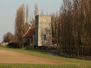
Thrandeston is a small village on the Norfolk/Suffolk border in England.
Ringshall is a village and civil parish in the Mid Suffolk district of Suffolk in eastern England. Located around four miles south of Stowmarket, and 13 miles north west of Ipswich.

Withersfield is a village and civil parish in the West Suffolk district of Suffolk in eastern England. In 2011 its population was 450. It has a public house and a village hall, and centres on the parish church, St. Mary the Virgin. It is in a rural location, surrounded by farmland, yet only a mile north of the busy market town of Haverhill. Surrounding villages include Great Wratting, West Wickham and Great Thurlow.
Westley is a village and civil parish in the West Suffolk district of Suffolk in eastern England. It is located south of Junction 42 of the A14 providing primary access to adjacent market towns Bury St Edmunds (East) and Newmarket (West). The village consists of two central roads: Fornham Lane and Hill Road running north and south through the parish, with adjoining roads accommodating Westley's total population of 183.

Saint Mary at Stoke is a Grade I listed Anglican church in the Old Stoke area of Ipswich.

Hinton Waldrist is a village and civil parish in the Vale of White Horse, England. It was part of Berkshire until the 1974 boundary changes transferred it to Oxfordshire. The village is between Oxford and Faringdon, 9 miles (14 km) southwest of Oxford. The parish includes the hamlet of Duxford. The 2011 Census recorded the parish's population as 328.

Ufford is a village and civil parish in Suffolk, England. Its population of 808 at the 2001 census rose to 948 at the 2011 Census and was estimated at 1,008 in 2019. The village lies 2 miles south-south-west of Wickham Market and 13 miles north-east of Ipswich. The main road through the village was renumbered B1438 after its replacement as a trunk road by the new A12.
Benjamin Ingelow was an English architect who practised from an office in London.

St Cross South Elmham is a village and civil parish in the north of the English county of Suffolk. It is in the East Suffolk district, close to the border with Norfolk and is 3 miles (4.8 km) east of Harleston and 4.25 miles (6.84 km) south-west of Bungay. It is one of the villages around Bungay known as the Saints.

Richard Dykes Alexander was a businessman and philanthropist based in Ipswich, Suffolk.

John Dupuis Cobbold was a member of the Ipswich-based Cobbold family in England.

John Speed's Ipswich is a graphic account of the town of Ipswich, Suffolk created by John Speed in conjunction with the Dutch engraver, Jodocus Hondius, in 1610. It was featured as an inset for his map of the county of Suffolk, published in Theatre of The Empire of Great Britaine. It is the earliest extant map of Ipswich and features many buildings of the late medieval period, whilst at the same time showing streets laid out in a grid pattern which has largely been retained into the twenty first century.

St George's Chapel, was a religious building located in Ipswich, Suffolk, England. The spot where it was located is now occupied by St George's Terrace, in St Georges Street. This lies just to the north of the historic town centre of Ipswich. It was from this chapel that Thomas Bilney was taken in 1527 and accused of heresy. No trace of the building remains.
Henry Tooley was a Suffolk, England merchant. Alive during the Tudor period, by the time of his death he was one of the richest businessmen in the town of Ipswich. He was closely associated with the fellow merchant and Member of Parliament for Ipswich, Robert Daundy. His trade network extended Biscayan ports, the Netherlands and Iceland as well as including much of East Anglia east of line drawn between Chelmsford and Thetford – and the highly populated and industry towns of south Suffolk in particular.
Frederick Brett Russell was an English architect and artist based in Ipswich, Suffolk.

