
The Australian Capital Territory (ACT), known as the Federal Capital Territory (FCT) until 1938, is a federal territory of Australia. Canberra, the capital city of Australia, is located in this territory. It is located in southeastern Australian mainland as an enclave completely within the state of New South Wales. Founded after Federation as the seat of government for the new nation, the territory hosts the headquarters of all important institutions of the Australian Government.

Protected areas of Australia include Commonwealth and off-shore protected areas managed by the Australian government, as well as protected areas within each of the six states of Australia and two self-governing territories, the Australian Capital Territory and the Northern Territory, which are managed by the eight state and territory governments.

The Jervis Bay Territory is an internal territory of Australia. It was established in 1915 from part of New South Wales (NSW), in order to give the landlocked Australian Capital Territory (ACT) access to the sea.

The City of Shoalhaven is a local government area in the South Coast region of New South Wales, Australia. The area is about 200 kilometres (120 mi) south of Sydney. The Princes Highway passes through the area, and the South Coast railway line traverses the northern section, terminating at Bomaderry. At the 2021 census, the population was 108,531.

Booderee National Park and Botanic Gardens, formerly Jervis Bay National Park and Jervis Bay Botanic Gardens, are located in the Jervis Bay Territory of Australia. The reserve is composed of two sections:

Jervis Bay is a 102-square-kilometre (39 sq mi) oceanic bay and village on the south coast of New South Wales, Australia, said to possess the whitest sand in the world.
The Kaurna people are a group of Aboriginal people whose traditional lands include the Adelaide Plains of South Australia. They were known as the Adelaide tribe by the early settlers. Kaurna culture and language were almost completely destroyed within a few decades of the British colonisation of South Australia in 1836. However, extensive documentation by early missionaries and other researchers has enabled a modern revival of both language and culture. The phrase Kaurna meyunna means "Kaurna people".

Winmalee is a town in New South Wales, Australia. Winmalee is located 77 kilometres west of Sydney, in the local government area of the City of Blue Mountains. At the 2011 census, Winmalee had a population of 6,593.
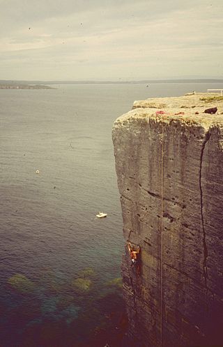
Beecroft Peninsula is the northern headland of Jervis Bay, on Australia's east coast. On the western and southern sides of the peninsula steep sandstone cliffs rise out of the ocean, up to 91 metres at its southernmost point, Point Perpendicular. White sandy beaches are found along the northern, eastern and southern sides interspersed with numerous intertidal reefs.

The New South Wales Office of Environment and Heritage (OEH), a former division of the Government of New South Wales between April 2011 and July 2019, was responsible for the care and protection of the environment and heritage, which includes the natural environment, Aboriginal country, culture and heritage, and built heritage in New South Wales, Australia. The OEH supported the community, business and government in protecting, strengthening and making the most of a healthy environment and economy within the state. The OEH was part of the Department of Planning and Environment cluster and managed national parks and reserves.

Jervis Bay National Park, formerly known as Jervis Bay National Park (NSW), consists of several protected areas on the western and northern foreshores of Jervis Bay, on the south coast of New South Wales. The park is close to the town of Huskisson and includes Hyams Beach, renowned for its white sand, whale watching and fishing opportunities.
Hyams Beach is a seaside village in the City of Shoalhaven, New South Wales, Australia, on the shores of Jervis Bay. At the 2016 census, it had a population of 112. The village, 180 km south of Sydney, is bordered by two beaches, Chinaman's Beach to the north and Seaman's Beach to the south, with Hyams Beach being in the centre. A seaside resort, its beach is known for having turquoise/aqua-coloured waters and fine, squeaky, brilliantly white sand composed of pure quartz.

Sussex Inlet is a town in the South Coast region of New South Wales, Australia. The town lies on the west bank of the waterway called Sussex Inlet, which divides New South Wales from the Jervis Bay Territory. The town lies within the City of Shoalhaven.

Greenpatch is a locality in the Jervis Bay Territory, Australia. It is located inside Boodere National Park.

Cape St George Lighthouse was a lighthouse that stood near Jervis Bay Village, Jervis Bay Territory, Australia. It was located about 3 kilometres (1.9 mi) south of the southern entrance to Jervis Bay. Constructed in 1860 it was active until 1889. The tower was destroyed between 1917–1922 to avoid confusion in daylight. The ruins remain and are listed on the Commonwealth Heritage List.
The South Coast Pipe is a surf spot in the Jervis Bay Territory, Australia. It takes its name from the Banzai Pipeline in Hawaii because both breaks share many characteristics. It was originally known as just "Pipeline" or "Wreck Bay" by the few surfers who knew about it in the second half of the 1960s. The term "Black Rock" was coined by an Australia Surfing Magazine in 1970 but it remained little-known until the late 1980s.

An Indigenous Protected Area (IPA) is a class of protected area used in Australia; each is formed by voluntary agreement with Indigenous Australians, and declared by Aboriginal Australians and Torres Strait Islander representative organisations. Each is formally recognised by the Australian Government as being part of its National Reserve System. The areas may comprise land and sea, and are managed by Indigenous groups for the conservation of biodiversity. Managing IPAs also helps to protect the cultural values of their country for future generations, and has benefits for Indigenous health, education, economic and social cohesion.

Bowen Island is a sandstone island lying 250 metres (270 yd) off the tip of the Bherwerre Peninsula at the entrance to Jervis Bay, on the coast of New South Wales, Australia. The island, however, is not part of the state of New South Wales but of the Jervis Bay Territory, administered by Australia's federal government. It lies within the Booderee National Park. In the 1990s it was raised as a prospective site to establish an internment camp for drug users to recover from heroin addiction.

Bherwerre Beach is a long beach located in Booderee National Park, Jervis Bay Territory, Australia. It is approximately 7 kilometres (4.3 mi) long and is bordered by Cave Beach to the east and Sussex Inlet to the west.
Nikita Ridgeway is a Bundjalung/Biripi tattoo artist and graphic designer from Australia, who was awarded the a BBC 100 Women Award in 2015 in recognition of her entrepreneurial work and advocacy for Aboriginal graphic design.

