
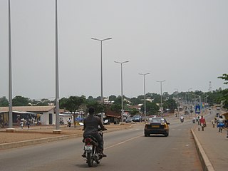
Tamale is the capital city of the Northern Region of Ghana. It is Ghana's third largest city, with a population of 950,000. The city has been ranked as the fastest-growing city in West Africa. It is located 600 km (370 mi) north of Accra.

Sudano-Sahelian architecture refers to a range of similar indigenous architectural styles common to the African peoples of the Sahel and Sudanian grassland (geographical) regions of West Africa, south of the Sahara, but north of the fertile forest regions of the coast.

Bolgatanga, colloquially known as Bolga, is a town and the capital of the Bolgatanga Municipality and Upper East Region of Ghana, adjacent to the border with Burkina Faso. Bolgatanga has over 2012 settlements and a population of about 66,685 people. Bolgatanga is 161 km to the north of Tamale. Bolgatanga lies in the Red Volta River Valley, with the White Volta River and the cliffs of the Gambaga Escarpment to the south of the town forming the southern boundary of the Upper East Region.
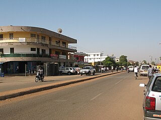
Wa is the capital town of Wa Municipal and Upper West Region of northern Ghana. It forms part of the eleven Municipalities and Districts that make-up the Upper West Region. It’s Municipal Assembly is one of the 261 Metropolitan, Municipal and District Assemblies (MMDAs) in Ghana.

The Northern Region is one of the sixteen regions of Ghana. It is located in the north of the country, and it is the second largest of the sixteen regions. Until its split, it covered an area of 25,000 square kilometres, or 10 percent of Ghana's area. In December 2018, the Savannah Region and North East Region were created from it. The Northern Region is divided into 14 districts. The region's capital is Tamale, Ghana's third largest city.

East Mamprusi Municipal Assembly is one of the six districts in North East Region, Ghana. Originally created as an ordinary district assembly in 1988 when it was known as East Mamprusi District, which was created from the former Mamprusi District Council, until the eastern part of the district was split off by a decree of president John Agyekum Kufuor on 19 August 2004 to create Bunkpurugu-Yunyoo District; thus the remaining part has been retained as East Mamprusi District. However on 15 March 2018, it was elevated to municipal district assembly status to become East Mamprusi Municipal District. The municipality is located in the eastern part of North East Region and has Gambaga as its capital town.
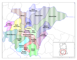
Ejisu-Juaben Municipal District is a former district that was located in the Ashanti Region of Ghana. Originally created as an ordinary district assembly on 10 March 1989 when it was known as Ejisu-Juaben District which was created from the former Ejisu-Juaben-Bosomtwe District Council. It was later elevated to municipal district assembly status in 2007 to become Ejisu-Juaben Municipal District. However on 15 March 2018, it was split off into two new municipal districts: Ejisu Municipal District and Juaben Municipal District. The municipality was located in the central part of Ashanti Region and had Ejisu as its capital town.

Savelugu-Nanton Municipal District is a former district that was located in Northern Region, Ghana. Originally created as an ordinary district assembly in 1988; which was created from the former West Dagomba District Council. It was later elevated to municipal district assembly status on 1 March 2012. However on 28 June 2012, it was split off into two new districts: Savelugu Municipal District and Nanton District. The municipality was located in the eastern part of Northern Region and had Nanton as its capital town.
Tamale Metropolitan District is one of the sixteen districts in Northern Region, Ghana. Originally created as a municipal district assembly in 1988 when it was known as Tamale Municipal District, which was created from the former West Dagomba District Council, until it was elevated to metropolitan district assembly status in August 2004. Later, a small northern part of the district was split off to create Sagnarigu District on 24 June 2012 ; thus the remaining part has been retained as Tamale Metropolitan District. The metropolis is located in the northwest part of Northern Region and has Ghana as its capital city. The metro poly is the central business hub of the region.
West Mamprusi Municipal Assembly is one of the six districts in North East Region, Ghana. Originally created as an ordinary district assembly in 1988 when it was known as West Mamprusi District, which was created from the former Mamprusi District Council, until the western part of the district was split off on 28 June 2012 to create Mamprugu-Moagduri District; thus the remaining part has been retained as West Mamprusi District. However, on 15 March 2018, it was elevated to municipal district assembly status to become West Mamprusi Municipal District. The municipality is located in the western part of North East Region and has Walewale as its capital town. Other settlements within the municipal assembly include Wulugu.
Gushegu Municipal District is one of the sixteen districts in Northern Region, Ghana. Originally it was formerly part of the then-larger Gushegu-Karaga District in 1988, which was created from the former East Dagomba District Council, until the western part of the district was split off to create Karaga District on 27 August 2004; thus the remaining part has been renamed as Gushegu District, which it was later elevated to municipal district assembly status on that same year to become Gushegu Municipal District. The municipality is located in the northeast part of Northern Region and has Gushegu as its capital town.

The railway stations in Ghana serve a rail network concentrated in the south of the country.
Damongo is a town and the capital of West Gonja Municipal, a municipal in the Savannah Region of northern Ghana. On 12 February 2019, Damongo was declared the capital of the newly created Savannah Region; With the coming into force of the Constitutional Instrument (CI) 105, which was signed into force by the President of the Republic of Ghana and presented to the Yagbonwura in Jubilee House Accra. Damongo hosts the Overlord of the Gonja Kingdom; the Yagbonwura. It is also the capital in the Damongo Constituency whose current MP is Hon. Samuel Abu Jinapor. The languages spoken in Damongo include Gonja, Vagla, Hanga, Dagaare, Waale, Frafra, Kasim, Twi, Ewe, and Hausa.

Walewale is a town and the capital of Mamprusi West Municipal in the North East Region of Ghana. The West Mamprusi Municipal is one of the 261 Metropolitan, Municipal, and District Assemblies (MMDAs) in Ghana, and forms part of the 6 MMDAs in the North East Region. The West Mamprusi Municipality is one of 45 new districts created in 1988 under the Government of Ghana’s decentralization and was later replaced with LI 2061 in 2012. With its administrative capital as Walewale.

The Tamale Teaching Hospital is a teaching hospital in Tamale in the Northern region and the third largest hospital in Ghana. It serves as a referral hospital for the five northern regions of Ghana. The main hospital in Northern Ghana is 2 km southeast of town. It cooperates with the University for Development Studies in Northern Ghana to offer undergraduate and graduate programs in medicine, nursing, and nutrition. It is the third teaching hospital in Ghana after the Korle Bu Teaching Hospital and the Komfo Anokye Teaching Hospital.
Mion District is one of the sixteen districts in Northern Region, Ghana. Originally it was formerly part of the then-larger Yendi District in 1988, which was created from the former East Dagomba District Council, until the western part of the district was later split off to create Mion District on 28 June 2012; thus the remaining original part has bee retained to become Yendi Municipal District. The district assembly is located in the central part of Northern Region and has Sang as its capital town.
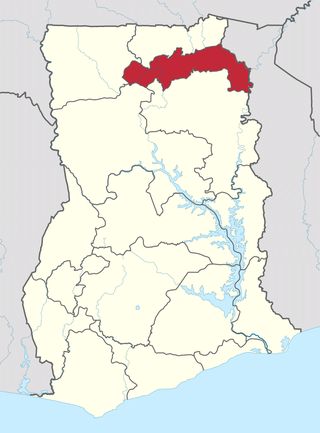
The North East Region is one of the sixteen regions of Ghana. It is located in the north of the country and was created in December 2018 after a referendum was voted upon to break it off of the Northern region. The region's capital is Nalerigu.
Sagnarigu Municipal is one of the sixteen districts in Northern Region, Ghana. Originally it was formerly part of the then-larger Tamale Municipal District in 1988, which was created from the former West Dagomba District Council, until a small northern part of the district was split off to create Sagnarigu District on 24 June 2012; thus the remaining part has been retained as Tamale Metropolitan District. However, on 15 March 2018, it was elevated to municipal district assembly status to become Sagnarigu Municipal District. The municipality is located in the northwest part of Northern Region and has Sagnarigu as its capital city. However Tamale remains the capital city of the Northern Region.
Sang is a town in the Northern Region of north Ghana. The Mion District is one of the new districts created in 2018 in Ghana. It used to be part of the Yendi Municipal District. It is the capital of the Mion District. The largest town to the west is Tamale and to the east is Yendi.

New Juaben South Municipal Assembly is one of the thirty-three districts in Eastern Region, Ghana. Originally it was formerly part of the then-larger New Juaben Municipal District in 1988 until the northern part of the district was split off to create New Juaben North Municipal Assembly on 15 March 2018; thus the remaining part has been renamed as New Juaben South Municipal Assembly. The municipality is located in the central part of the Eastern Region and has Koforidua as its capital town.

