Wörth, Upper Bavaria

Last updated • a couple of secsFrom Wikipedia, The Free Encyclopedia
Wörth
St. Petrus Woerth Lkr. Erding-3.jpg
Church of Saint Peter
DEU Worth (Landkreis Erding) COA.svg
Location of Wörth within Erding district
Worth in ED.svgBockhornTaufkirchenWartenbergKirchbergFraunbergIsenWörth
Germany adm location map.svg
Red pog.svg
Wörth
Bavaria location map.svg
Red pog.svg
Wörth
Coordinates: 48°14′N11°54′E / 48.233°N 11.900°E / 48.233; 11.900
Country Germany
State Bavaria
Admin. region Oberbayern
District Erding
Municipal assoc. Hörlkofen
Government
   Mayor (202026) Thomas Gneißl [1]
Area
  Total21.05 km2 (8.13 sq mi)
Highest elevation
520 m (1,710 ft)
Lowest elevation
480 m (1,570 ft)
Population
 (2023-12-31) [2]
  Total4,483
  Density210/km2 (550/sq mi)
Time zone UTC+01:00 (CET)
  Summer (DST) UTC+02:00 (CEST)
Postal codes
85457
Dialling codes 08123, 08122
Vehicle registration ED
Website www.vg-hoerlkofen.de

Wörth (German pronunciation: [vœʁt] ) is a municipality in the district of Erding in Bavaria in Germany.

Related Research Articles

<span class="mw-page-title-main">Oberaudorf</span> Municipality in Bavaria, Germany

Oberaudorf is a municipality in the district of Rosenheim in Bavaria, Germany. It lies on the river Inn.

<span class="mw-page-title-main">Baar, Bavaria</span> Municipality in Bavaria, Germany

Baar is a municipality in Aichach-Friedberg district, in Bavaria, southern Germany.

<span class="mw-page-title-main">Roding, Germany</span> Town in Bavaria, Germany

Roding is a town in the district of Cham, in Bavaria, Germany, near the Czech border.

<span class="mw-page-title-main">Pegnitz (town)</span> Town in Bavaria, Germany

Pegnitz is a town in the Bayreuth district in Upper Franconia, Bavaria, Germany, with a population of approximately 15,000 inhabitants. It is also the source of the river Pegnitz. The city Bayreuth is about 27 km to the north.

<span class="mw-page-title-main">Gräfelfing</span> Municipality in Bavaria, Germany

Gräfelfing is a municipality in the district of Munich, in Bavaria, Germany. It is located 1 km west of Munich.

<span class="mw-page-title-main">Ergolding</span> Municipality in Bavaria, Germany

Ergolding is a municipality in the district of Landshut, in Bavaria, Germany. It is situated on the left bank of the Isar, 5 km northeast of Landshut.

<span class="mw-page-title-main">Pleystein</span> Town in Bavaria, Germany

Pleystein is a municipality in the district of Neustadt an der Waldnaab, in Bavaria, Germany. It is situated 18 km east of Weiden in der Oberpfalz, and 11 km west of Rozvadov.

<span class="mw-page-title-main">Thannhausen</span> Town in Bavaria, Germany

Thannhausen is a town in the district of Günzburg, in Bavaria, Germany. It is situated on the river Mindel, 24 kilometres (15 mi) southeast of Günzburg, and 33 kilometres (21 mi) west of Augsburg.

<span class="mw-page-title-main">Eggolsheim</span> Municipality in Bavaria, Germany

Eggolsheim is a municipality in the district of Forchheim in Bavaria in Germany.

<span class="mw-page-title-main">Dürrwangen</span> Municipality in Bavaria, Germany

Dürrwangen is a municipality in the district of Ansbach in Bavaria in Germany.

<span class="mw-page-title-main">Ohrenbach</span> Municipality in Bavaria, Germany

Ohrenbach is a municipality in the district of Ansbach in Bavaria in Germany.

<span class="mw-page-title-main">Petersaurach</span> Municipality in Bavaria, Germany

Petersaurach is a municipality in the district of Ansbach in Bavaria in Germany.

<span class="mw-page-title-main">Wald, Upper Palatinate</span> Municipality in Bavaria, Germany

Wald is a municipality in the district of Cham in Bavaria in Germany.

<span class="mw-page-title-main">Heroldsbach</span> Municipality in Bavaria, Germany

Heroldsbach is a municipality in the district of Forchheim in Bavaria in Germany.

<span class="mw-page-title-main">Seinsheim</span> Municipality in Bavaria, Germany

Seinsheim is a municipality in the district of Kitzingen in Bavaria in Germany. It is best known for its connection with the comital Seinsheim family (german), which died out in 1958 except for the princely House of Schwarzenberg branch of the family.

<span class="mw-page-title-main">Leuchtenberg</span> Municipality in Bavaria, Germany

Leuchtenberg is a municipality in the district of Neustadt an der Waldnaab in Bavaria, Germany, essentially a suburb of nearby Weiden in der Oberpfalz, and a larger historical region in the Holy Roman Empire governed by the Landgraves of Leuchtenberg.

<span class="mw-page-title-main">Oberstaufen</span> Municipality in Bavaria, Germany

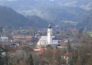
Oberstaufen is a municipality in the district of Oberallgäu in Bavarian Swabia, Germany, situated on the B 308 road from Lindau to Immenstadt.

<span class="mw-page-title-main">Beratzhausen</span> Municipality in Bavaria, Germany

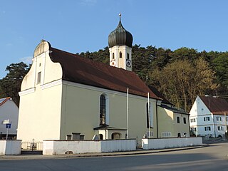
Beratzhausen is a market town and municipality in the district of Regensburg in Bavaria in Germany.

<span class="mw-page-title-main">Brannenburg</span> Municipality in Bavaria, Germany

Brannenburg is a municipality in the district of Rosenheim in Bavaria in Germany. There is a railway station located in Brannenburg.

<span class="mw-page-title-main">Kist, Bavaria</span> Municipality in Bavaria, Germany

Kist is a municipality in the district of Würzburg in Bavaria in Germany.

References