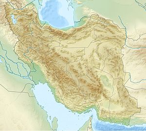
Location | Golestan Province, Iran |
---|---|
Coordinates | 37°08′53″N55°12′01″E / 37.148°N 55.2004°E Coordinates: 37°08′53″N55°12′01″E / 37.148°N 55.2004°E |
Type | Settlement |
Site notes | |
Condition | In ruins |
Yarim Tepe is a Neolithic settlement in the eastern Gorgan plain, Golestan Province. It is located near Gonbad-e Kavus. This ancient settlement played a big role in establishing the cultural chronology of the neolithic period in Central Asia.
It was first explored by V. E. Crawford in 1963, when very little was still known about the neolithic age settlements in this area. [1] There are many cultural similarities between Yarim and the nearby site of Tureng Tepe of the same age.
Just like at Tureng Tepe, in the earliest horizon, there occur Jeitun-like ceramics, that are found mostly in the Koppet Dag mountains area, [2] but also at several other contemporary sites in the Gorgan plain, for example in the Hotu cave, and even further west near Behshahr.
In Period I at Yarim Tepe, the Jeitun ware was identified as “Yarim Neolithic”. [3]
The early stage of Yarim I is generally dated c. 5200 BC. In Southern Turkmenistan, this is also known as ‘Pessejik period’. In Northeastern Iran, along with Yarim I, to this period also belong Hotu cave, and Tureng 'IA'. In North-central Iran, this period is known as ‘Transitional Chalcolithic’, and it is parallel to Sialk II stratum. [4] [5]
At Yarim Tepe there is a gap between the Djeitun-ware levels and the overlying gray-ware levels (Yarim II). [6]
Gorgan, formerly Esterabad , is the capital city of Golestan Province, Iran. It lies approximately 400 km (250 mi) to the north east of Tehran, some 30 km (19 mi) away from the Caspian Sea. In the 2006 census; its population was 269,226, in 73,702 families.
The Bactria–Margiana Archaeological Complex (BMAC) is the modern archaeological designation for a particular Bronze Age civilization of Central Asia also known as the Oxus Civilization. The civilization's urban phase or Integration Era was previously dated by Sandro Salvatori to c. 2400–1900 BC, but was more recently dated to c. 2250–1700 BC.
Teppe Hasanlu or Hasanlu Tepe is an archeological site of an ancient city located in northwest Iran, a short distance south of Lake Urmia. The nature of its destruction at the end of the 9th century BC essentially froze one layer of the city in time, providing researchers with extremely well preserved buildings, artifacts, and skeletal remains from the victims and enemy combatants of the attack.
Tepe Sialk is a large ancient archeological site in a suburb of the city of Kashan, Isfahan Province, in central Iran, close to Fin Garden. The culture that inhabited this area has been linked to the Zayandeh River Culture.
The Yaz culture was an early Iron Age culture of Margiana, Bactria and Sogdia. It emerges at the top of late Bronze Age sites (BMAC), sometimes as stone towers and sizeable houses associated with irrigation systems. Ceramics were mostly hand-made, but there was increasing use of wheel-thrown ware. There have been found bronze or iron arrowheads, also iron sickles or carpet knives among other artifacts.
Ganj Dareh is a Neolithic settlement in western Iran. It is located in the Harsin County in east of Kermanshah Province, in the central Zagros Mountains.
Teppe Zagheh is an early urban settlement located near Qazvin, Iran. In Persian, Tappeh means "tell, mound". It was first excavated by a team from the University of Tehran under the direction of Ezzat Negahban in the early 1970s
Altyndepe, is a Bronze Age (BMAC) archaeological site in Turkmenistan, near Aşgabat, inhabited first from c. 3200 to 2400 BCE in the Late Regionalization Era, and from c. 2400 to 2000 BCE in the Integration Era as a full urban site.
Jajarm is a city and capital of Jajarm County, in North Khorasan Province, Iran.
The Hassuna culture is a Neolithic archaeological culture in northern Mesopotamia dating to the early sixth millennium BC. It is named after the type site of Tell Hassuna in Iraq. Other sites where Hassuna material has been found include Tell Shemshara.
Tureng Tepe is a Neolithic and Chalcolithic archaeological site in northeastern Iran, in the Gorgan plain, approximately 17 km northeast of the town of Gorgan. Nearby is a village of Turang Tappeh.
Cheshmeh-Ali is an ancient recreational place, located in the south of Tehran and north of Rey in the country of Iran. The spring is spot in the neighborhood of Ebn-e Babooyeh, Tughrul Tower, and below the Rashkan castle and next to Rey Castle and Fath Ali shah inscription. In the past, carpet sellers and people used to wash their carpets there, with their idea that the property of this spring water is good and clean for carpets and make them full lighter color by its mineral water.
Tepe Hissar is a prehistoric site located in the village Heydarabad just south of Damghan in Semnan Province in northeastern Iran.
Deh Kheyr is a village in Kharqan Rural District, Bastam District, Shahrud County, Semnan Province, Iran. At the 2006 census, its population was 182, in 39 families.
The South Turkmenistan Complex Archaeological Expedition (STACE), also called the South Turkmenistan Archaeological Inter-disciplinary Expedition of the Academy of Sciences of the Turkmen Soviet Socialist Republic (YuTAKE) was endorsed by the Turkmenistan Academy of Sciences. It was initially organized by the orientalist Mikhail Evgenievich Masson in 1946. The expedition had several excavations or "Brigades", based on sites and periods, and were spread over many years.
Jeitun (Djeitun) is an archaeological site of the Neolithic period in southern Turkmenistan, about 30 kilometers north of Ashgabat in the Kopet-Dag mountain range. The settlement was occupied from about 7200 to 4500 BC possibly with short interruptions. Jeitun has given its name to the whole Neolithic period in the foothills of the Kopet Dag.
Yarim Tepe is an archaeological site of an early farming settlement that goes back to about 6000 BC. It is located in the Sinjar valley some 7km southwest from the town of Tal Afar in northern Iraq. The site consists of several hills reflecting the development of the Hassuna culture, and then of the Halaf and Ubaid cultures.
Sang-i Chakmak is a Neolithic archaeological site located about 1 km (0.62 mi) north of the village of Bastam in the northern Semnan Province of Iran, on the southeastern flank of the Elburs Mountains. The site represents quite well the transition from the aceramic Neolithic phase in the general area; this was taking place during the 7th millennium BC.
The Gorgan Plain, or Dasht-e Gorgan, is situated in northeastern Iran in Golestan Province. It extends from the lower slopes of the Alborz and Kopet Dag mountain ranges to the steppes of Turkmenistan. The River Gorgan flows through the plain from east to west, emptying into the Caspian Sea. The provincial capital Gorgan lies to the south of the plain, which covers an area of about 170 square kilometres (66 sq mi) and is situated between 37°00' and 37°30' north latitude, and between 54°00' and 54°30' east longitude. The annual precipitation in the south of the plain is about 600 mm (24 in) which is much higher than the 200 mm (8 in) just 60 km (37 mi) to the north. The southern part is very fertile, being watered by the many streams that flow from the Alborz Mountains.
The Anau culture was an ancient agricultural civilization of Central Asia centred in southern Turkmenistan. It started during the Chalcolithic period around 4000 BC, following the Neolithic Jeitun culture. It is named after its main site of Anau, Turkmenistan.