Kabarole District is a district in Western Uganda. Kabarole District is part of the Kingdom of Toro. Its main town is Fort Portal.
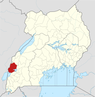
Kasese District is a district in Western Uganda. Like most other Ugandan districts, the town of Kasese is the site of the district headquarters.

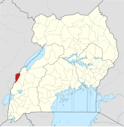
Bundibugyo is a town in Western Uganda. It is the 'chief town' of Bundibugyo District and the district headquarters are located there.
Semliki River is a major river, 140 kilometres (87 mi) long, in the Democratic Republic of the Congo (DRC) and Uganda in Central and East Africa. It flows north from Lake Edward to Lake Albert in the Albertine Rift west of the Rwenzori Mountains. Along its lower reaches, it forms part of the international border between the DRC and the western Ugandan district of Bundibugyo, near the Semuliki National Park. It empties into Lake Albert slightly west of the border in Orientale Province of the DRC.

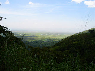
Semuliki National Park, is located in Bwamba County, a remote part of the Bundibugyo District, in the Western Region of Uganda. It was made a national park in October 1993 and is one of Uganda's newest national parks. 219 km2 (85 sq mi) of East Africa's only lowland tropical rainforest is found in the park. It is one of the richest areas of floral and faunal diversity in Africa, with bird and butterfly species being especially diverse. The park is managed by the Uganda Wildlife Authority.
Articles related to Uganda include:

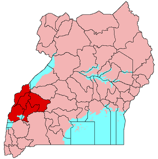
Rwenzururu is a subnational kingdom in western Uganda, located in the Rwenzori Mountains on the border with the Democratic Republic of the Congo. The kingdom includes the districts of Bundibugyo, Kasese and Ntoroko. Rwenzururu is also the name given to the region the kingdom is located in.
The Konzo, or Konzo, are a people located in the Rwenzori Mountains of southwest Uganda. Numbering 850,646 in the 2014 census, they live on the plains, hills and mountain sloping up to an altitude of 2,200 meters. Traditionally agriculturalists and animal husbanders, they farm yams, beans, sweet potatoes, peanuts, soy beans, potatoes, rice, wheat, cassava, coffee, bananas, and cotton, while keeping goats, sheep, and poultry. They speak the Konjo language and practice traditional religions and Christianity. Konzo speakers also live on the western slopes of the Rwenzori range in the Democratic Republic of the Congo.
The Amba are a people located in border area of the Democratic Republic of the Congo and Uganda south of Lake Albert in the northern foothills of the Rwenzori Mountains. On the Uganda side, they are found in Bundibugyo District. On the Congolese side, they are located in the Watalinga and Bawisa subcounties of Beni, South Kivu. Numbering 42,559 on the Uganda side in the 2014 census and 4,500 on the Congolese side according to a 1991 SIL International estimate, Ethnologue lists their total population as 40,100. Agriculturalists, the Amba traditionally cultivate plantains, millet, maize, sweet potatoes, peanuts, rice, coffee, cotton, and cassava, while raising goats and sheep. The Amba practice Christianity.

Ntoroko District is a district in the Western Region of Uganda. The district headquarters are in the Kibuuku town council.
Toro sub-region is a region in Uganda that is coterminous with Toro Kingdom in Western Uganda. The districts that constitute the sub-region include the following:
The Songora or Shongora also known as "Bacwezi", "Chwezi", Huma or "Bahuma") are a traditionally a pastoralist people of the Great Lakes region of Central Africa located in Western Uganda and Eastern Democratic Republic of the Congo. They have distinctive customs and speak 'Rusongora' an African language that is originates from Proto-Kordofanian and is similar to Runyankole and Runyoro. The Basongora population has reported as numbering 25,000 in 2015 in Uganda. Some Basongora also live in Eastern Congo.

The 1966 Toro earthquake, or the 1966 Ruwenzori earthquake, occurred on March 20 at 01:42 UTC. The earthquake was located near the border between Uganda and the Democratic Republic of the Congo (DRC), to the south of Lake Albert. Some sources put the epicenter in Uganda while some put it in the Democratic Republic of the Congo. The earthquake had a magnitude of 6.8 and a maximum perceived intensity of VIII (Severe) on the Mercalli intensity scale.
Nyakasura School is a mixed, boarding, middle, and high school in Fort Portal, Kabarole District, Western Region of Uganda.
The Fort Portal–Bundibugyo–Lamia Road is in the Western Region of Uganda. It links Fort Portal in the Kabarole District with the towns of Bundibugyo and Lamia in the Bundibugyo District.

Violence erupted on 26 November 2016 in the town of Kasese, the capital of the Ugandan Kingdom of Rwenzururu, when Uganda security forces raided the government offices of the Rwenzururu kingdom, killing eight Rwenzururian royal guards and arresting two others. According to the government of Uganda, the raid was in response to militant attacks on police posts in the region two weeks earlier, allegedly perpetrated by the royal guards.
The Rwenzururu movement was an armed secessionist movement active in southwest Uganda, in the subnational kingdom of Tooro. The group was made up of Konjo and Amba fighters and was led by Isaya Mukirania. It disbanded in 1982 following successful peace negotiations with the Ugandan government.

Kitagwenda District is a district in Western Uganda. The district is named after Kitagwenda County, which is coterminous with the district.