Yentna Glacier

Last updated
Yentna Glacier
Relief map of USA Alaska.png
Red pog.svg
Yentna Glacier
TypeValley glacier
Coordinates 62°43′07″N151°40′57″W / 62.71861°N 151.68250°W / 62.71861; -151.68250 Coordinates: 62°43′07″N151°40′57″W / 62.71861°N 151.68250°W / 62.71861; -151.68250
Yentna Glacier

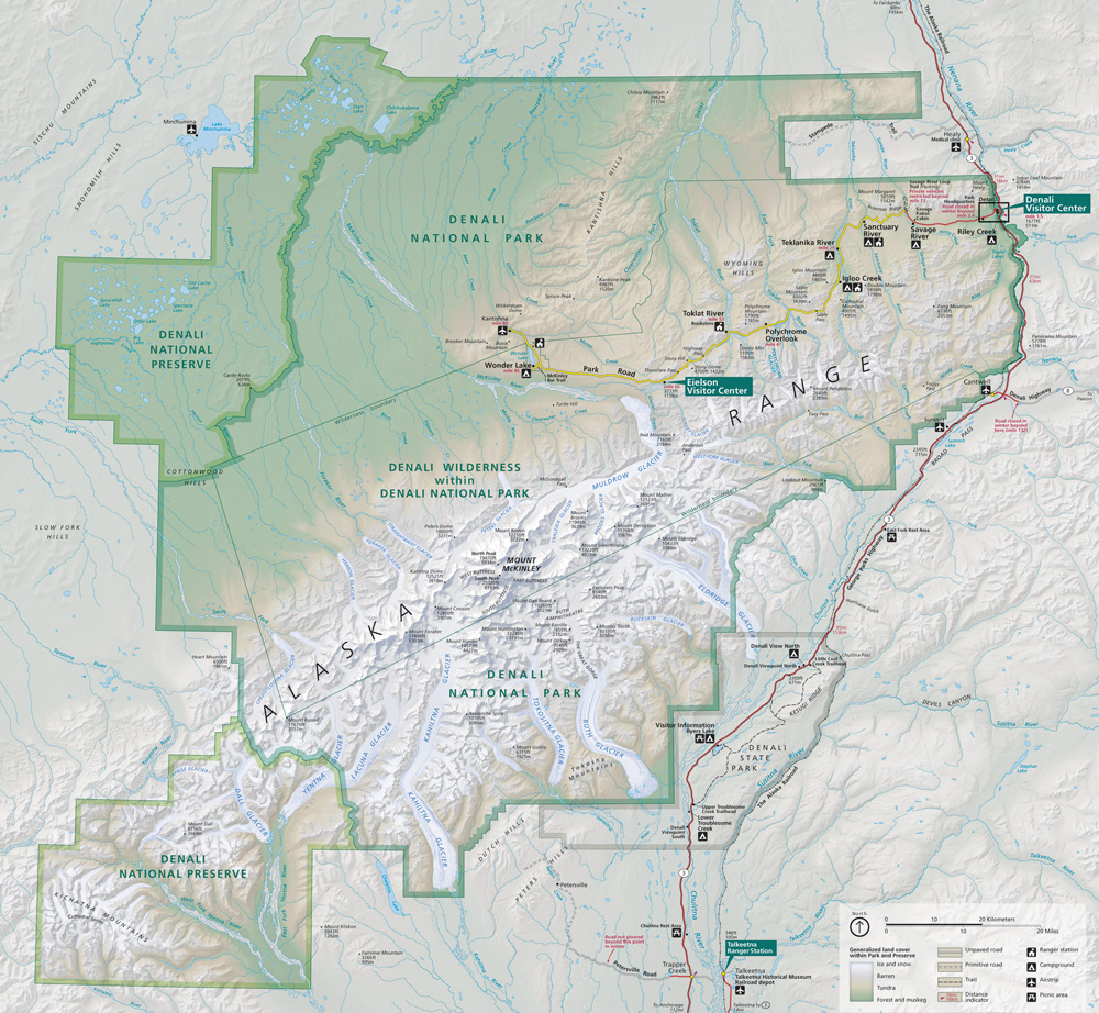
Yentna Glacier is a glacier in Denali National Park and Preserve in the U.S. state of Alaska. The glacier begins in the Alaska Range between Mount Russell and Mount Foraker, moving southwest. It is the source of the east fork of the Yentna River. Lacuna Glacier is a major tributary, and Dall Glacier enters the glacial valley just below Yentna Glacier's present terminus. [1] [2] [3]

Contents

See also

Related Research Articles

Denali Highest mountain in North America

Denali is the highest mountain peak in North America, with a summit elevation of 20,310 feet (6,190 m) above sea level. With a topographic prominence of 20,194 feet (6,155 m) and a topographic isolation of 4,621.1 miles (7,436.9 km), Denali is the third most prominent and third most isolated peak on Earth, after Mount Everest and Aconcagua. Located in the Alaska Range in the interior of the U.S. state of Alaska, Denali is the centerpiece of Denali National Park and Preserve.

Denali National Park and Preserve National park in Alaska, USA

Denali National Park and Preserve, formerly known as Mount McKinley National Park, is an American national park and preserve located in Interior Alaska, centered on Denali, the highest mountain in North America. The park and contiguous preserve encompass 6,045,153 acres which is larger than the state of New Hampshire. On December 2, 1980, 2,146,580-acre Denali Wilderness was established within the park. Denali's landscape is a mix of forest at the lowest elevations, including deciduous taiga, with tundra at middle elevations, and glaciers, snow, and bare rock at the highest elevations. The longest glacier is the Kahiltna Glacier. Wintertime activities include dog sledding, cross-country skiing, and snowmobiling. The park received 594,660 recreational visitors in 2018.

Kahiltna Glacier is the longest glacier of the Alaska Range in the U.S. state of Alaska. It starts on the southwest slope of Denali near Kahiltna Pass. Its main channel runs almost due south between Mount Foraker to the west and Mount Hunter to the east. The name was first reported as "Car-ilt-nu Glacier" by Alaska Range explorer Lt. J.S. Herron in 1902. An alternate name is Kagheltnu Li'a. Kahiltna Glacier is the longest glacier in the Alaska Range at 44 miles (71 km) in length.

Peters Glacier, also known as Hanna Glacier and Hudeetsedle Toyaane' is a glacier in Denali National Park and Preserve in the U.S. state of Alaska. The glacier runs from the Peters Basin icefield in a deep valley to the north of Denali's Wickersham Wall, between Denali and Peters Dome, falling from the icefield via the Tluna Icefall, where it is joined by Jeffery Glacier. It exits the Alaska Range to the north, forming the source of the Muddy River. Peters Glacier was named by A.H. Brooks for U.S. Geological Survey topographer William John Peters, who surveyed in Alaska from 1898 to 1902. Until 1947 it was named Hanna Glacier for U.S. Senator from Ohio Marcus Alonzo Hanna, a friend of President William McKinley.

Lacuna Glacier is a glacier in Denali National Park and Preserve in the U.S. state of Alaska. The glacier begins on the south side of Mount Foraker in the Alaska Range, moving southwest to join the Yentna Glacier, to which Lacuna is a tributary.

Dall Glacier is a glacier in Denali National Park and Preserve in the U.S. state of Alaska. The glacier begins in the Alaska Range on Mount Russell, moving southwest, then south to the Yentna River just below the present terminus of Yentna Glacier.

Chedotlothna Glacier is a glacier in Denali National Park and Preserve in the U.S. state of Alaska. The glacier begins in the Alaska Range between Mount Russell and Mount Dall moving northeast, then north. It is the source of the Swift Fork of the Kuskokwim River. The name Chedotlothna was reported as a native name by S.R. Capps in 1925. Alternate spellings include Chedotlothno and Chedotluthna. The glacier is also called Todzolno' Lughwzra'.

Surprise Glacier is a glacier in Denali National Park and Preserve in the U.S. state of Alaska. The glacier begins in the Alaska Range near Mount Dall, moving west. Its terminus is the source of the Tonzona River.

Herron Glacier is a glacier in Denali National Park and Preserve in the U.S. state of Alaska. The glacier begins in the Alaska Range on the north side of Mount Foraker, moving northwest for 14 miles (23 km). It is the source of the Herron River. The name was given by A.H. Brooks of the U.S. Geological Survey to honor Lt. Joseph S. Herron, who mapped much of the region.

Foraker Glacier is a glacier in Denali National Park and Preserve in the U.S. state of Alaska. The glacier begins in the Alaska Range on the north side of Mount Foraker, moving northwest for 15 miles (24 km). It is the source of the Foraker River.

Straightaway Glacier, also known as Crosson Glacier, is a glacier in Denali National Park and Preserve in the U.S. state of Alaska. The glacier begins in the Alaska Range on the north side of Mount Crosson, moving northwest. It is a source of the Foraker River.

Traleika Glacier

Traleika Glacier is a glacier in Denali National Park and Preserve in the U.S. state of Alaska. The glacier originates from two forks on either side of Farthing Horn on the east side of Denali. The west fork of the glacier starts in the Thayer Basin to the south of Denali, moving northeast and falling from the basin's 15,000-foot (4,600 m) height via the Traleika Icefall into the west fork between Karsten Ridge and the Farthing Horn. The main fork starts from Denali's east buttress in Traleika Col, joining the West Fork between the Farthing Horn and Mount Silverthrone, then moving northeast to join Muldrow Glacier. Traleika Glacier was named in 1945 by Bradford Washburn, attributing the name to a Susitna name meaning "great one" or "high one.". The form Traleika is an Anglicization of the Dena'ina name Dghelaay Ka'a, denoting Denali.

Brooks Glacier is a glacier in Denali National Park and Preserve in the U.S. state of Alaska. The glacier originates on the east face of Mount Silverthrone at Brooks Gap. The 9-mile (14 km) glacier moves northeast, joining Muldrow Glacier between Mount Brooks and Ragged Peak. Brooks Glacier was named by T.G. Gerdine of the U.S. Geological Survey circa 1900 for geologist Alfred Hulse Brooks.

Muldrow Glacier

Muldrow Glacier, also known as McKinley Glacier, is a large glacier in Denali National Park and Preserve in the U.S. state of Alaska. Native names for the glacier include, Henteel No' Loo' and Henteel No' Loot.

Eldridge Glacier is a major glacier in Denali National Park and Preserve in the U.S. state of Alaska. The 30-mile (48 km) long glacier originates on the east side of Explorers Peak, flowing northeast to a basin below Mount Eldridge, gathering flow from several glaciated cirques, then flowing southeast to the valley of the Chulitna River, where it gives rise to the Fountain River. A large unnamed tributary glacier joins Eldridge Glacier a few miles above its terminus.

Cul-de-sac Glacier is a glacier in the Alaska Range of Denali National Park and Preserve in the U.S. state of Alaska. The glacier begins in the Kichatna Mountains on the side of Kichatna Spire, moving north. Its run-off and that of neighboring Shelf and Shadows glaciers feeds the west fork of the Yentna River.

Shelf Glacier is a glacier in the Alaska Range of Denali National Park and Preserve in the U.S. state of Alaska. The glacier begins in the Kichatna Mountains on the side of Kichatna Spire, moving north. It is a tributary to neighboring Shadows Glacier, which with Cul-de-sac Glacier feeds the west fork of the Yentna River.

Shadows Glacier is a glacier in the Alaska Range of Denali National Park and Preserve in the U.S. state of Alaska. The glacier begins in the Kichatna Mountains on the north side of the Cathedral Spires, moving north. It receives neighboring Shelf Glacier as a tributary, and together with Cul-de-sac Glacier feeds the west fork of the Yentna River.

Kanikula Glacier., also known as Little Tokositna Glacier, is an 11-mile (18 km) long glacier in the Alaska Range of Denali National Park and Preserve in the U.S. state of Alaska. The glacier originates in a series of glacial amphitheaters in the south side of the range, moving southeast past Mount Goldie and ending before the valley of Tokositna Glacier. Variant forms and spellings of the name include K'enik'ela Li'a, Kahnicula Glacier, Kanicula Glacier and Little Tokasitna Glacier.

Tokositna Glacier Glacier in Alaska, United States

Tokositna Glacier is a glacier in the Alaska Range of Denali National Park and Preserve in the U.S. state of Alaska. The glacier originates in two major arms on the east side of Mount Hunter, moving east until the main arms join, then turning south. Tokositna Glacier is the source of the Tokositna River. Spelling variants and alternate names include Tokasitna Glacier, Tokichitna Glacier and Tuqashitnu Li'a.

References

  1. "Map of Denali National Park and Preserve". Denali National Park and Preserve. National Park Service. Retrieved 25 March 2013.
  2. Denali National Park and Preserve (Map). !:225,000. National Geographic Maps. 2007. ISBN   978-1-56695-328-3.
  3. "Yentna Glacier". Geographic Names Information System . United States Geological Survey . Retrieved 2013-03-29.