Yik'in Chan K'awiil

Last updated
Yik'in Chan K'awiil
Ajaw of Tikal
27th in the line

TempleIIILintelMaudslay.jpg

Yik'in Chan K'awiil as depicted in a lintel from Tikal Temple IV. [1]
Reign December 8, 734-c.746/after751/766?
Predecessor Jasaw Chan K'awiil I
Successor 28th Ruler
Born before 734
Died c.746/afer751/766?
Issue 28th Ruler
Yax Nuun Ahiin II
Father Jasaw Chan K'awiil I
Mother Lady Lahan Unen Mo'
Religion Maya religion

Yik'in Chan K'awiil [N 1] also known as Ruler B, Yaxkin Caan Chac and Sun Sky Rain, (before 734-c.746/766?), was an ajaw of the Maya city of Tikal. He took the throne on December 8, 734. [N 2] [2]

Ajaw

Ajaw or Ahau ('Lord') is a pre-Columbian Maya political title attested from epigraphic inscriptions. It is also the name of the 20th day of the tzolk'in, the Maya divinatory calendar, on which a king's k'atun-ending rituals would fall.

Maya civilization Mesoamerican civilization

The Maya civilization was a Mesoamerican civilization developed by the Maya peoples, and noted for its logosyllabic script—the most sophisticated and highly developed writing system in pre-Columbian Americas—as well as for its art, architecture, mathematics, calendar, and astronomical system. The Maya civilization developed in an area that encompasses southeastern Mexico, all of Guatemala and Belize, and the western portions of Honduras and El Salvador. This region consists of the northern lowlands encompassing the Yucatán Peninsula, and the highlands of the Sierra Madre, running from the Mexican state of Chiapas, across southern Guatemala and onwards into El Salvador, and the southern lowlands of the Pacific littoral plain.

Tikal Ruins of major ancient Maya city

Tikal is the ruin of an ancient city, which was likely to have been called Yax Mutal, found in a rainforest in Guatemala. It is one of the largest archaeological sites and urban centers of the pre-Columbian Maya civilization. It is located in the archaeological region of the Petén Basin in what is now northern Guatemala. Situated in the department of El Petén, the site is part of Guatemala's Tikal National Park and in 1979 it was declared a UNESCO World Heritage Site.

Contents

Biography

Yik'in Chan K'awiil's glyph Yik'in Chan K'awiil.svg
Yik'in Chan K'awiil's glyph

Identified by Mayanist epigraphers as the 27th ruler in Tikal's dynastic succession, [3] Yik'in Chan K'awiil was one of Tikal's most successful and expansionary rulers, consolidating the political gains won by his father, Jasaw Chan K'awiil I. During his reign prolific building works were undertaken at Tikal, with a number of the site's significant still-standing structures commissioned or extended under his direction. Before advances in the decipherment of the Maya script revealed this reading of his name, this ruler was also known to researchers as Tikal Ruler B. [2]

A Mayanist is a scholar specialising in research and study of the Mesoamerican pre-Columbian Maya civilization. This discipline should not be confused with Mayanism, a collection of New Age beliefs about the ancient Maya.

Jasaw Chan Kawiil I Rulers of Tikal

Jasaw Chan K'awiil I also known as Ruler A, Ah Cacao and Sky Rain,, was an ajaw of the Maya city of Tikal. He took the throne on May 3, 682 and reigned until his death.

Maya script writing system of the Maya civilization

Maya script, also known as Maya glyphs, was the writing system of the Maya civilization of Mesoamerica and is the only Mesoamerican writing system that has been substantially deciphered. The earliest inscriptions found which are identifiably Maya date to the 3rd century BCE in San Bartolo, Guatemala. Maya writing was in continuous use throughout Mesoamerica until the Spanish conquest of the Maya in the 16th and 17th centuries.

Yik'in K'awiil conquered Calakmul in 736 and two other Calakmul allies in 743 and 744: El Peru to the east and Naranjo to the west, destroying the noose of power that had previously dominated the area. [4]

Calakmul archaeological site

Calakmul is a Maya archaeological site in the Mexican state of Campeche, deep in the jungles of the greater Petén Basin region. It is 35 kilometres (22 mi) from the Guatemalan border. Calakmul was one of the largest and most powerful ancient cities ever uncovered in the Maya lowlands.

El Perú (Maya site) pre-Columbian Maya archaeological site in Guatemala

El Perú, is a pre-Columbian Maya archeological site occupied during the Preclassic and Classic cultural chronology periods. The site was the capital of a Maya city-state and is located near the banks of the San Pedro River in the Department of Petén of northern Guatemala. El Perú is 60 km (37 mi) west of Tikal.

Naranjo

Naranjo is a Pre-Columbian Maya city in the Petén Basin region of Guatemala. It was occupied from about 500 B.C. to 950 A.D, with its height in the Late Classic Period. The site is part of Yaxha-Nakum-Naranjo National Park. The city lies along the Mopan and Holmul rivers, and is about 50 km east of the site of Tikal. Naranjo has been the victim of severe looting. The site is known for its polychrome ceramic style

His principal wife was a princess of Palenque; her personal name is unknown, but her formal title was Lady Yax Ahau Xoc. It is unknown exactly where his tomb lies, but strong archaeological parallels between Burial 116 (the resting place of his father) and Burial 196, located in the diminutive pyramid immediately south of Tikal Temple II and referred to as Structure 5D-73, suggest the latter may be the tomb of Yik’in Chan Kawiil. Other possible locations, and likely candidates as mortuary shrines, include Tikal Temple IV and Tikal Temple VI. [5] [6]

Palenque former city state in Central Amrica in present-day southern Mexico

Palenque, also anciently known as Lakamha, was a Maya city state in southern Mexico that flourished in the 7th century. The Palenque ruins date from ca. 226 BC to ca. AD 799. After its decline, it was absorbed into the jungle of cedar, mahogany, and sapodilla trees, but has since been excavated and restored. It is located near the Usumacinta River in the Mexican state of Chiapas, about 130 km (81 mi) south of Ciudad del Carmen, 150 m (164 yd) above sea level. It averages a humid 26 °C (79 °F) with roughly 2160 mm (85 in) of rain a year.

Archaeology, or archeology, is the study of human activity through the recovery and analysis of material culture. The archaeological record consists of artifacts, architecture, biofacts or ecofacts and cultural landscapes. Archaeology can be considered both a social science and a branch of the humanities. In North America archaeology is a sub-field of anthropology, while in Europe it is often viewed as either a discipline in its own right or a sub-field of other disciplines.

Pyramid structure whose shape is roughly that of a pyramid in the geometric sense

A pyramid is a structure whose outer surfaces are triangular and converge to a single point at the top, making the shape roughly a pyramid in the geometric sense. The base of a pyramid can be trilateral, quadrilateral, or of any polygon shape. As such, a pyramid has at least three outer triangular surfaces. The square pyramid, with a square base and four triangular outer surfaces, is a common version.

The monuments and texts associated with Yik'in Chan K'awiil are: Stelae 5, 20? and 21; Altars 2, 8? and 9; Column Altars 1, 2? and 3?; Temple 4 Lintels 2 and 3; Lintel from Structure 5D-52; Tikal Rock Sculpture?. [2]

Notes

  1. The ruler's name, when transcribed is ?-(ya)-CHAN-K'AWI:L-la, translated "K'awiil that Darkens the Sky", Martin & Grube 2008, p.48.
  2. These are the dates indicated on the Maya inscriptions in Mesoamerican Long Count calendar, Accession: 9.15.3.6.8 3 Lamat 6 Pax, Martin & Grube 2008, p.48.

Footnotes

  1. Sharer & Traxler 2006, p. 401.
  2. 1 2 3 Martin & Grube 2008, p.48.
  3. Sharer & Traxler 2006, p. 313; Tikal Stela 5 records his lineage statement, as the 27th successor from the founder of Tikal's dynastic line.
  4. Martin & Grube 2008, p.49.
  5. Sharer & Traxler 2006, pp.304–305
  6. Martin & Grube 2008, p.50.

Related Research Articles

Copán archaeological site of the Maya civilization

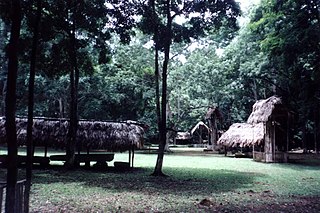
Copán is an archaeological site of the Maya civilization in the Copán Department of western Honduras, not far from the border with Guatemala. It was the capital city of a major Classic period kingdom from the 5th to 9th centuries AD. The city was in the extreme southeast of the Mesoamerican cultural region, on the frontier with the Isthmo-Colombian cultural region, and was almost surrounded by non-Maya peoples.

Dos Pilas human settlement

Dos Pilas is a Pre-Columbian site of the Maya civilization located in what is now the department of Petén, Guatemala. It dates to the Late Classic Period, being founded by an offshoot of the dynasty of the great city of Tikal in AD 629 in order to control trade routes in the Petexbatún region, particularly the Pasión River. In AD 648 Dos Pilas broke away from Tikal and became a vassal state of Calakmul, although the first two kings of Dos Pilas continued to use the same emblem glyph that Tikal did. It was a predator state from the beginning, conquering Itzan, Arroyo de Piedra and Tamarindito. Dos Pilas and a nearby city, Aguateca, eventually became the twin capitals of a single ruling dynasty. The kingdom as a whole has been named as the Petexbatun Kingdom, after Lake Petexbatún, a body of water draining into the Pasión River.

Uaxaclajuun Ubaah Kawiil Ruler of the Maya associated with the site of Copán

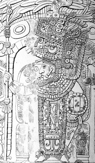
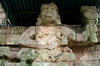
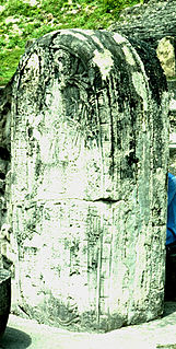
Uaxaclajuun Ub'aah K'awiil, was the 13th ajaw or ruler of the powerful Maya polity associated with the site of Copán in modern Honduras. He ruled from January 2, 695, to May 3, 738.

Tikal Temple I

Tikal Temple I is the designation given to one of the major structures at Tikal, one of the largest cities and archaeological sites of the pre-Columbian Maya civilization in Mesoamerica. It is located in the Petén Basin region of northern Guatemala. It also is known as the Temple of the Great Jaguar because of a lintel that represents a king sitting upon a jaguar throne. An alternative name is the Temple of Ah Cacao, after the ruler buried in the temple. Temple I is a typically Petén-styled limestone stepped pyramid structure that is dated to approximately 732 AD.

Yax Nuun Ahiin II ruler of the Maya civilization polity of Tikal

Yax Nuun Ahiin II also known as Ruler C and Chitam,, was an ajaw of the Maya city of Tikal. He took the throne on December 25, 768 and reigning probably until his death. He was son of Yik'in Chan K'awiil and brother of 28th Ruler. The monuments associated with Yax Nuun Ahiin II are: Stelae 19, 21 and Altars 6 and 10.

Balaj Chan Kawiil King of Dos Pilas

B'alaj Chan K'awiil was a Maya ruler of Dos Pilas. He is also known as Ruler 1, Flint Sky God K and Malah Chan K'awil.

Jasaw Chan Kawiil II

Jasaw Chan K'awiil II also known as Stela 11 Ruler,, was an ajaw of the Maya city of Tikal. He ruled c.869. The monuments associated with Jasaw Chan K'awiil II are: Stela 11 and Altar 11.

Rulers of Tikal Wikimedia list article

The known rulers of Tikal, a major centre of the Pre-Columbian Maya civilization in modern-day Guatemala:

Tikal Temple II temple in Tikal

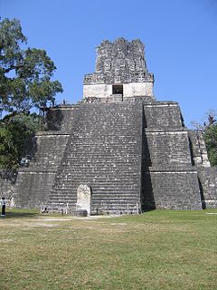
Tikal Temple II is a Mesoamerican pyramid at the Maya archaeological site of Tikal in the Petén Department of northern Guatemala. The temple was built in the Late Classic Period in a style reminiscent of the Early Classic. Temple II is located on the west side of the Great Plaza, opposite Temple I. Temple II was built by the king Jasaw Chan K'awiil I in honour of his wife, Lady Kalajuun Une' Mo'. Temple II had a single wooden sculpted lintel that bears the portrait of a royal woman who may have been the wife of Jasaw Chan K'awiil I, who was entombed beneath Temple I. Lady Kalajuun Une' Mo', whose name means "Twelve Macaw Tails", was also important for being the mother of Jasaw Chan K'awill I's heir. In fact her son Yik'in Chan K'awiil oversaw the completion of Temple II when he became king.

Tikal Temple IV

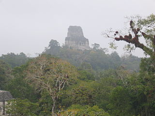
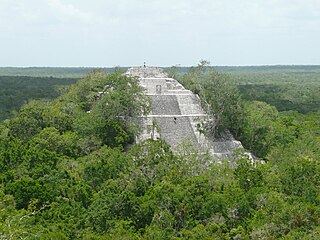
Tikal Temple IV is a Mesoamerican pyramid in the ruins of the ancient Maya city of Tikal in modern Guatemala. It was one of the tallest and most voluminous buildings in the Maya world. The pyramid was built around 741 AD. Temple IV is located at the western edge of the site core. Two causeways meet at the temple; the Tozzer Causeway runs east to the Great Plaza, while the Maudslay Causeway runs northeast to the Northern Zone. Temple IV is the tallest pre-Columbian structure still standing in the New World, although Teotihuacan's Pyramid of the Sun may once have been taller.

Lady Lahan Unen Mo Mayan queen

Lady Lahan Unen Mo' also known as Lady 12 Baby Macaws and Kalajuun Une' Mo' was a Maya queen of Tikal as a wife of ajaw Jasaw Chan K'awiil I. She was the mother of ajaw Yik'in Chan K'awiil. She died in c.704.

Calakmul Ruler Y

Ruler Y was a Maya king of Calakmul. He is also known as Ruler 8 and Bolon K'awiil I. He reigned >741>.

North Acropolis, Tikal

The North Acropolis of the ancient Maya city of Tikal in Guatemala is an architectural complex that served as a royal necropolis and was a centre for funerary activity for over 1300 years. The acropolis is located near the centre of the city and is one of the most studied of Maya architectural complexes. Excavations were carried out from 1957 to 1969 by the University of Pennsylvania, directed by Edwin M. Shook and William Coe.

Kak Yipyaj Chan Kawiil

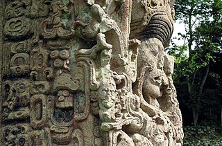
K'ak' Yipyaj Chan K'awiil was a ruler of the Mayan city of Copán. He was the son of K'ak' Joplaj Chan K'awiil. The early period of his rulership fell within Copán's hiatus but later on he began a programme of renewal in an effort to recover from the earlier disaster of the city. He built a new version of Temple 26, with the Hieroglyphic Stairway being reinstalled on the new stairway and doubled in length. Five life-size statues of seated rulers were installed seated upon the stairway. K'ak' Yipyaj Chan K'awiil died in the early 760s and is likely to have been interred in Temple 11, although the tomb has not yet been excavated.

Third Tikal–Calakmul War

The Third Tikal–Calakmul War was the third in a series of wars between Tikal and Calakmul, two of the Major superpowers of the Maya Civilization during the classic period.

28th Ruler was an ajaw of the Maya city of Tikal. He ruled c.766-768. Little is known about this ruler. He was a son of 27th ruler of Tikal Yik'in Chan K'awiil and elder brother of his successor 29th ruler Yax Nuun Ahiin II.

References

Martin, Simon; Nikolai Grube (2008). Chronicle of the Maya Kings and Queens: Deciphering the Dynasties of the Ancient Maya (2nd ed.). London and New York: Thames & Hudson. ISBN   9780500287262. OCLC   191753193. 
Sharer, Robert J.; Loa P. Traxler (2006). The Ancient Maya (6th, fully revised ed.). Stanford, CA: Stanford University Press. ISBN   0-8047-4816-0. OCLC   28067148. 
Regnal titles
Preceded by
Jasaw Chan K'awiil I
Ajaw of Tikal
December 8, 734-c.746
Succeeded by
28th Ruler