
Kaiser Franz Joseph Fjord is a major fjord system in the NE Greenland National Park area, East Greenland.

Andrée Land is a peninsula in King Christian X Land, East Greenland that is bounded by Kejser Franz Joseph Fjord, Isfjord and Geologfjord.

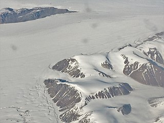
Waltershausen Glacier is one of the major glaciers in Greenland. It has its terminus on the east coast of the Greenland ice sheet.

Storstrommen, is one of the major glaciers in northeastern Greenland. The North-East Greenland Ice Stream (NEGIS) discharges into 3 main marine-terminating outlets: 79N Glacier, Zachariae Isstrøm and Storstrommen - as arranged North to South.

King Frederik VIII Land is a major geographic division of northeastern Greenland. It extends above the Arctic Circle from 76°N to 81°N in a North-South direction along the coast of the Greenland Sea.
Queen Louise Land is a vast mountainous region located west of Dove Bay, King Frederik VIII Land, northeastern Greenland. Administratively it is part of the Northeast Greenland National Park zone.

Revaltoppe is one of the highest mountains in Queen Louise Land, NE Greenland. The peak is located in the King Frederick VIII Land area of northeastern Greenland. Administratively it is part of the Northeast Greenland National Park zone.
Gefiontinde is the highest mountain in Queen Louise Land, NE Greenland. The peak is located in the King Frederick VIII Land area of northeastern Greenland. Administratively it is part of the Northeast Greenland National Park zone.
Louise Boyd Land is an area in King Christian X Land, Eastern Greenland. Administratively it lies in the Northeast Greenland National Park zone. The area is remote and uninhabited.

Hamberg Glacier is one of the major glaciers in King Christian X Land, Northeast Greenland. Administratively it lies in the Northeast Greenland National Park zone.
Adolf Hoel Glacier, also known as Hoel Glacier(Hoels Gletscher), is one of the major glaciers in King Christian X Land, Northeast Greenland. Administratively it lies in the Northeast Greenland National Park zone.

Nunatak Glacier, also known as Nunatak Glacier, is a glacier in King Christian X Land, Northeast Greenland. Administratively it lies in the Northeast Greenland National Park zone.
Duke of Orleans Land is a land area —possibly a peninsula— in King Frederick VIII Land, northeastern Greenland. Administratively it belongs to the NE Greenland National Park area.
Alabama Nunatak is a nunatak in the King Frederik VIII Land area of northeastern Greenland. Administratively it is part of the Northeast Greenland National Park zone.

Britannia Lake, is a lake in King Frederik VIII Land, Northeastern Greenland. The lake and its surroundings are part of the Northeast Greenland National Park zone.

Britannia Glacier is a glacier in Queen Louise Land, northeastern Greenland. Administratively it belongs to the Northeast Greenland National Park.

Eventyrfjelde is a group of nunataks in Queen Louise Land, NE Greenland. Administratively it is part of the Northeast Greenland National Park zone.

Carlsbergfondet Land is a group of nunataks in Queen Louise Land, NE Greenland. Administratively it is part of the Northeast Greenland National Park zone.
Borgjokel is a glacier in Queen Louise Land, northeastern Greenland. Administratively it belongs to the Northeast Greenland National Park.


