
The Menai Strait is a narrow stretch of shallow tidal water about 25 km (16 mi) long, which separates the island of Anglesey from the mainland of Wales. It varies in width from 400 metres (1,300 ft) from Fort Belan to Abermenai Point to 1,100 metres (3,600 ft) from Traeth Gwyllt to Caernarfon Castle. It then narrows to 500 metres (1,600 ft) in the middle reaches and then it broadens again. At Bangor, Garth Pier, it is 900 metres (3,000 ft) wide. It then widens out, and the distance from Puffin Island to Penmaenmawr is about 8 kilometres (5.0 mi).

Menai Bridge is a town and community on the Isle of Anglesey in north-west Wales. It overlooks the Menai Strait and lies by the Menai Suspension Bridge, built in 1826 by Thomas Telford, just over the water from Bangor. With a population of 3,376, it is the fifth largest town on the island. The built-up area including Llandegfan had a population of 4,958.
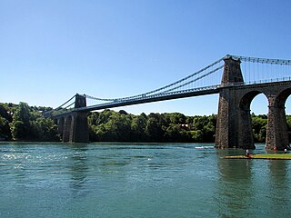
The Menai Suspension Bridge is a suspension bridge spanning the Menai Strait between the island of Anglesey and the mainland of Wales. Designed by Thomas Telford and completed in 1826, it was the world's first major suspension bridge. The bridge still carries road traffic and is a Grade I listed structure.
The Skerries, coming from the Old Norse word sker, are a group of sparsely vegetated rocky islets (skerries), with a total area of about 17 hectares lying 3 kilometres (1.9 mi) offshore from Carmel Head at the northwest corner of Anglesey, Wales. The islands are important as a breeding site for seabirds, and they attract divers, who come to visit the numerous shipwrecks. The Skerries Lighthouse sits atop the highest point in the islands.

Ynys Gored Goch, sometimes Ynys Gorad Goch, is a small island in the Menai Strait between Gwynedd and Anglesey in north Wales. It is situated in the stretch of the strait called the Swellies between Thomas Telford's Menai Suspension Bridge and Robert Stephenson's Britannia Bridge.

Puffin Island is an uninhabited island off the eastern tip of Anglesey, Wales. It was formerly known as Priestholm in English and Ynys Lannog in Welsh. A hermitage was established here around the 6th century, and there are remains of a 12th-century monastery on the island. The island is also a Special Protection Area for wildlife.

Ynys Castell is a small island in the Menai Strait which separates Anglesey and mainland Wales. It is an extruding piece of Precambrian schist lying to one side of the Afon Cadnant estuary. It lies between Ynys y Bîg and Ynys Gaint. There is a causeway running to the island that is covered at high tide. On the island there is a private house. Ynys Castell means Castle Island in Welsh.

Ynys Gaint is a small island in the Menai Strait connected to the town of Menai Bridge on Anglesey by a causeway and also a concrete bridge erected by Sir William Fison in the 1930s. Literally translated Ynys Gaint mean Kent Island.
Church Island, also known as Llandysilio Island, is a small island in the Menai Strait on the shores of Anglesey to which it is attached by a short causeway that is reachable only on foot. The dominant feature of the island is with St Tysilio's Church, constructed in the 15th century, its churchyard, and a grade-II listed war memorial. The 20th-century bard Cynan is among several notable people buried in the churchyard. The Anglesey Coastal Path passes the head of the causeway.
Dulas Bay is a small bay on the north east coast of Anglesey, north Wales, forming the boundary between Llaneilian and Moelfre communities. The bay is bordered by three beaches.
The Anglesey Coastal Path is a 200-kilometre (124 mi) long-distance footpath around the island of Anglesey in North Wales. The route is part of the Wales Coast Path.

The Isle of Anglesey County Council is the local authority for the Isle of Anglesey, a principal area with county status in Wales. Since 2022 the council has 35 councillors who represent 11 multi-member electoral wards.
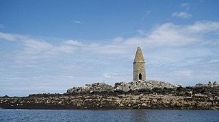
Ynys Dulas is a small island located off the north-east coast of Anglesey, Wales. It marks the most eastern part of the parish of Llaneilian.

The Isle of Anglesey is a county off the north-west coast of Wales. It is named after the island of Anglesey, which makes up 94% of its area, but also includes Holy Island and some islets and skerries.

St Tysilio's Church is a medieval church in the village of Menai Bridge, Anglesey, Wales. The current building dates from the early 15th century and underwent renovations in the 19th century. It was designated as a Grade II* listed building on 14 February 1967.

The Menai Strait fish weirs are historically important fishing traps used in the fast-flowing tidal waters of the Menai Strait, which separates Anglesey from the rest of North Wales. The strait was particularly well suited to utilising fish weirs. The tidal waters pull huge volumes of water past the coastline with every tide, and the weirs and traps enabled fish to be concentrated into small holding areas from which they can be readily caught. Such methods are thought to have been used from earliest times, but the submerged and standing remains along both the Anglesey and Gwynedd coasts are from medieval and post-medieval periods, and in some cases were still in use into the 20th century.

Ynys Faelog is a small tidal island in the Menai Strait between Gwynedd and the Isle of Anglesey, Wales, near the town of Menai Bridge. On average it measures 140 metres by 130 metres and is connected by a narrow stone causeway to the Anglesey mainland. There is a two-storey house on the island with three outbuildings and a boathouse.

Virginia Ann Crosbie is a British Conservative Party politician who has been the Member of Parliament (MP) for Ynys Môn since the 2019 general election. Prior to her political career, she worked as a director at UBS and HSBC before retraining as a mathematics teacher.

