
The Seine is a 777-kilometre-long (483 mi) river in northern France. Its drainage basin is in the Paris Basin covering most of northern France. It rises at Source-Seine, 30 kilometres (19 mi) northwest of Dijon in northeastern France in the Langres plateau, flowing through Paris and into the English Channel at Le Havre. It is navigable by ocean-going vessels as far as Rouen, 120 kilometres (75 mi) from the sea. Over 60 percent of its length, as far as Burgundy, is negotiable by large barges and most tour boats, and nearly its whole length is available for recreational boating; excursion boats offer sightseeing tours of the river banks in the capital city, Paris.

Nièvre is a department in the Bourgogne-Franche-Comté region, central-east France. Named after the river Nièvre, it had a population of 204,452 in 2019. Its prefecture is Nevers.

Yonne is a département in the Bourgogne-Franche-Comté region in France. It is named after the river Yonne, which flows through it, in the country's north-central part. One of Bourgogne-Franche-Comté's eight constituent departments, it is located in its northwestern part, bordering Île-de-France. It was created in 1790 during the French Revolution. Its prefecture is Auxerre, with subprefectures in Avallon and Sens. Its INSEE and postcode number is 89.

The Oise is a river of Belgium and France, flowing for 341 km (212 mi) from its source in the Belgian province of Hainaut, south of Chimay. It crosses the border with France after about 20 km (12 mi). It flows into the Seine at Conflans-Sainte-Honorine, a north-western suburb of Paris. Its main tributary is the Aisne. It gave its name to the French departments of Oise and Val-d'Oise.

Moret-sur-Loing is a former commune in the Seine-et-Marne department in the Île-de-France region in north-central France. It is situated on the river Loing, close to its confluence with the Seine. Moret–Veneux-les-Sablons station has rail connections to Montargis, Melun, Montereau-Fault-Yonne, Laroche-Migennes and Paris.

The Canal de Bourgogne is a canal in the Burgundy historical region in east-central France. It connects the Yonne at Migennes with the Saône at Saint-Jean-de-Losne. Construction began in 1775 and was completed in 1832. The canal completes the link between the English Channel and the Mediterranean Sea, via the rivers Seine and the Yonne to the Saône and Rhône.

Montereau-Fault-Yonne, or simply Montereau, is a commune in the Seine-et-Marne department in the Île-de-France region in north-central France.

The Mayenne is a 202.3 km (125.7 mi) long river in western France, principally located in the French region of Pays de la Loire. Together with the river Sarthe and its tributary the Loir it forms the Maine, which is a tributary to the Loire.

The Lot, originally the Olt, is a river in France. It is a right-bank tributary of the Garonne. It rises in the Cévennes mountains, flowing west through Quercy, where it flows into the Garonne near Aiguillon, a total distance of 485 kilometres (301 mi). It gives its name to the départements of Lot and Lot-et-Garonne.

The Aisne is a river in northeastern France. It is a left tributary of the Oise. It gave its name to the French department of Aisne. It was known in the Roman period as Axona.

The Briare Canal is one of the oldest canals in France. Its construction started in 1604. It was the first summit level canal in Europe that was built using pound locks, connecting the Rhone-Saône and Seine valleys. It is 57 kilometres long and is part of the Bourbonnais route from Saint-Mammès on the Seine to Chalon-sur-Saône on the Saône.

Clamecy is a commune in the Nièvre department in central France.

The Blavet river flows from central Brittany and enters the Atlantic Ocean on the south coast near Lorient. It is 148.9 km (92.5 mi) long. The river is canalised for most of its length, forming one of the links in the Brittany canal system. It connects with the Canal de Nantes à Brest at Pontivy and runs to Hennebont, a distance of 60 km. From the last lock at Polvern, the river is tidal and considered as a maritime waterway, giving access to the seaport of Lorient and the Atlantic Ocean. It became more important when the western half of that system was cut off by the construction of the Guerlédan dam and hydropower plant. Today, boats coming from Nantes via Redon have to take the Canal du Blavet in order to reach the ocean near Lorient.
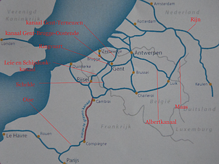
The Seine–Nord Europe Canal is a planned high-capacity canal in France that would link the Oise River at Compiègne with the Dunkirk-Scheldt Canal, east of Arleux. It is the French part of a proposed Seine-Scheldt canal that would ultimately connect the Rhine and Seine basins inland. The stated objective is to expand trade flows in a fuel-efficient and ecologically friendly manner between the Seine basin and Belgium, Germany and the Netherlands, while reducing saturation on the A1 motorway in France and reducing the CO2 emissions in the transport sector within this corridor.

Corbigny is a commune in the Nièvre department in central France.

Marigny-l'Église is a commune in the Nièvre department in central France
The Canal du Nivernais links the Loire with the Seine, following approximately the course of the river Yonne in a south to north direction. It first climbs northeast and north to cross the Morvan watershed, then roughly follows the course of the Yonne. Beginning on the Loire in the village of Saint-Léger-des-Vignes, it reaches its half-way point at the town of Clamecy and finishes at Auxerre on the Yonne.

The Oudon is a 103.2 km (64.1 mi) long river in the Mayenne and Maine-et-Loire départements, western France. Its source is near La Gravelle. It flows generally south east. It is a right tributary of the Mayenne into which it flows between Le Lion-d'Angers and Grez-Neuville.

The Loire is the longest river in France and the 171st longest in the world. With a length of 1,006 kilometres (625 mi), it drains 117,054 km2 (45,195 sq mi), more than a fifth of France's land, while its average discharge is only half that of the Rhône.
The Luciole is a converted French barge, or péniche. She was built in 1926. In 1966 she became the first hotel barge on the French canal system. She now operates on the Canal du Nivernais and River Yonne, her home mooring is in Auxerre.

