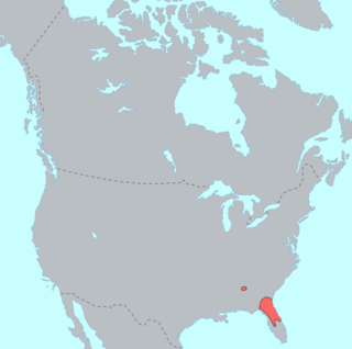
The Yustaga were a Timucua people of what is now northwestern Florida during the 16th and 17th centuries. The westernmost Timucua group, they lived between the Aucilla and Suwannee Rivers in the Florida Panhandle, just east of the Apalachee people. A dominant force in regional tribal politics, they may have been organized as a loose regional chiefdom consisting of up to eight smaller local chiefdoms.[1]
The Yustaga were closely associated with the Northern Utina people living on the other side of the Suwannee River, though they appear to have spoken a different dialect of the Timucua language, perhaps Potano. The Yustaga were among the first Timucua to encounter Europeans, as their location near the Apalachee ensured that several explorers passed through their territory looking for that group. After decades of resistance they were brought into the Spanish mission system in the 1620s. Like all Timucua groups, they experienced significant demographic decline in the period of European contact, especially following raids by English-allied Indians from the north. Surviving Yustaga eventually moved closer to the Spanish capital of St. Augustine and mingled with other missionized Indians, losing their independent identity.
Area
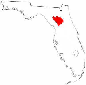
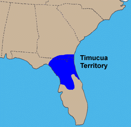
The westernmost of all Timucua groups, the Yustaga's territory extended into the Florida Panhandle and southwestern Georgia. They lived in the western Suwannee River valley, roughly between the Aucilla and Suwannee Rivers (present-day Madison and Taylor Counties).[2][3] On the east side of the Suwannee, inhabiting a territory spanning roughly to the St. Johns River in the east and the Santa Fe River in the south, lived another Timucua people, the Northern Utina. The Northern Utina were closely associated with the Yustaga, but spoke a different dialect, known as Timucua proper.[2] To the west of the Yustaga was a region known as the Apalachee Province, inhabited by the Apalachee and other peoples.[4]
Prehistorical era
The Yustaga region had been inhabited for thousands of years. During the first millennium AD its inhabitants participated in the Weedon Island culture, which spread across much of western Florida and beyond. From about 900 a derivative culture emerged among the peoples of the Suwannee River Valley, the groups later designated as the Yustaga and Northern Utina. This culture, known as the Suwannee Valley culture, is particularly distinguished by its ceramics, and was still extant at the time of European contact. As a Weedon Island derivative, it is closely related to the Alachua culture of the Potano, a Timucua group of what is now Alachua County.[5]
The dialect spoken by the Yustaga is unclear, as the tribe had not been missionized at the time Father Francisco Pareja, the principal source for the Timucua language and its dialects, undertook his linguistic work between 1612 and 1627.[6] However, a 1651 letter written by the Yustaga chief Manuel to the Spanish crown survives in the Spanish archives. The language of the letter is very similar to that in sources from the Potano tribe of present-day Alachua County, leading scholars such as the linguist Julian Granberry to conclude the Yustaga spoke the Potano dialect noted by Pareja.[7]
Archaeological evidence suggests that the Yustaga, like the Northern Utina, lived in distinct groups of villages, probably representing small-scale local chiefdoms.[8] Around eight such community groups were known in historical times.[1] Anthropologist John Worth suggests these might have been organized into a loose regional chiefdom that was continuous from at least the early period of European contact.[8] In this arrangement, the head of the most important town, Cotocochuni or Potohiriba, would have been paramount chief over all others. Possible evidence for this lies in the fact that later Spanish lists of Yustaga chiefs consistently name them in order of the prominence of their towns, with Potohiriba invariably first. Additionally, the Spanish built a mission at Potohiriba before any other Yustaga town, despite its comparatively remote location, suggesting it was already a center of considerable regional importance.[9]
Even still, Worth notes the regional Yustaga chiefdom would have been much less integrated than certain eastern Timucua chiefdoms such as the Saturiwa and (eastern) Utina. Ceramic dating may vary from community to community, suggesting a level of regional disunity, and no large-scale monuments such as platform mounds, often signs of integrated regional chiefdoms, have been discovered in Yustaga territory.[10]
European contact
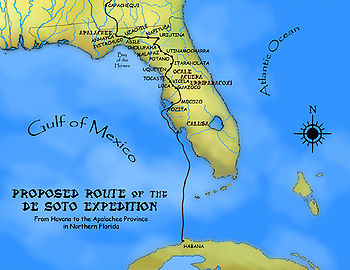
A suggested route for the first leg of the de Soto Expedition, passing through Uzachile and the Yustaga region. Based on Charles M. Hudson's 1997 map
The Yustaga appear to have encountered the expedition of Pánfilo de Narváez when it came through the area in 1528. Expedition survivor Álvar Núñez Cabeza de Vaca records a meeting with a great chief named Dulchanchellin, who lived east of Apalachee and may have been the predecessor to the later Yustaga paramount chiefs.[11][12]
However, the name "Yustaga" first appears in the chronicles of Hernando de Soto's 1539 expedition, which describe it as the region immediately east of Apalachee.[4] In de Soto's time the chiefdom was ruled by a chief named Uzachile, who was allied with (and possibly related to) the paramount chief on the other side of the Suwannee, Aguacaleycuen, whose domain corresponds to the later Northern Utina.[4] Uzachile may have been paramount over the various chiefdoms of more or less equal status on both sides of the river. They may have been in a defensive alliance against the Apalachees, the Utina (of the St. Johns River valley) and the Potano.[13]
Upon reaching Aguacaleycuen's village, De Soto captured the chief, as was his usual practice, intending to release him upon his party's safe arrival at Uzachile's village. Thereafter some chiefs approached de Soto and offered to take him to Uzachile, who they said sought an alliance against the Apalachee. Instead, they led the Spanish into an ambush. De Soto ultimately prevailed and subsequently executed Aguacaleycuen and other hostages, but by the time he got into Yustaga, the villages had already been evacuated.[4] De Soto and his men reached the town of Uzachile on 25 September, and stayed there for four days. One chronicler stated that there were 200 houses in the town, with plenty of maize, beans and pumpkins.[14]
Sources from the French Huguenot settlement of Fort Caroline, established in 1564, record a chief named "Houstaqua", whose name is probably a variant of Yustaga.[15] The French understood that Houstaqua and his neighbor, Onatheaqua (probably a chief of the Northern Utina), lived to the east of the Apalachee. However, they thought they lived near gold-bearing mountains (the Appalachian Mountains, which the Europeans thought extended into the Apalachee Province). French soldiers visited the Yustaga on two occasions, exchanging gifts with the chief and sojourning among his people for several months. The French reports credited Houstaqua with 3000 to 4000 warriors.[16][17]
Mission era
The Spanish, who displaced the French from Florida in 1565, established a system of missions to convert the natives to Christianity. Unlike most Timucua groups, who generally requested missionaries from the Spanish of their own volition, the Yustaga actively resisted Spanish missionary efforts.[18] Spanish records indicate that the paramount chief of the Yustaga consistently refused to allow missionaries to even enter his territory until the 1620s, over twenty years after missionization had begun among the Northern Utina and other interior groups.[19]
Around 1623 the chief of Cotocochuni, probably the main village of the Yustaga regional chiefdom, finally consented to two friars entering his territory, though he forbade his subjects from getting baptized or providing the missionaries with food.[19] Eventually, however, both the chief and his daughter converted to Christianity, and the conversion of the Yustaga proceeded quickly thereafter. Mission San Pedro de Potohiriba was established at Cotocochuni, and over time missions were built at the main villages of the other local chiefdoms.[20] This project, which established Yustaga as a province of the Spanish mission system, was the most significant of its kind in the early 17th century.[19]
Having much less frequent contact with the Europeans and the diseases they introduced, the Yustaga maintained stable population levels later than any other Timucua group. At the start of the mission period the Yustaga Province was by far the most populous, having an estimated 12,000 inhabitants, compared to only 7,500 in the Timucua Province, which at that time included the Northern Utina as well as the Potano and other groups.[21]
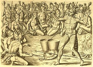
The Yustaga played what is often called the "Apalachee ball game." A missionary wrote an account of the Yustaga ball game in 1630. He indicated that the game was played with 50 or even 100 players on a team, and that large crowds would gather to watch the games. While the Apalachee yielded to missionary pressure and stopped playing the game in 1677, the Yustaga refused to do so, insisting that their version of the game did not have the moral problems of the Apalachee version. The game continued to be played by the Yustaga into the 1680s.[22]
The Western Timucua groups, the Potano, Northern Utina and Yustaga, rebelled against Spanish authority in 1656. Lúcas Menéndez, chief of San Martín de Ayacutu, and paramount chief of the Northern Utina, and Diego, chief of Potohiriba, and most powerful of the Yustaga chiefs, led the revolt. Potohiriba was the principal meeting place for the rebels. The rebels killed several Spaniards, a Mexican and some African slaves, but no missionaries. The chiefs of Machaba and Potohiriba were among the rebel leaders captured by the Spanish, and were executed for their roles in the rebellion.[23]
Four missions are known to have been still in use in 1688: Mission San Pedro y San Pablo de Potohiriba, Santa Elena de Machaba, San Miguel de Asile and San Matheo de Tolapatafi (San Miguel de Asile may have been an Apalachee mission). There were 330 families living at the four missions in 1689. Raids by English colonists in the Province of Carolina and their native allies in 1704 and the years following destroyed the missions in Yustaga.[24]
The Suwannee River is a river that runs through south Georgia southward into Florida in the southern United States. It is a wild blackwater river, about 246 miles (396 km) long. The Suwannee River is the site of the prehistoric Suwanee Straits that separated the Florida peninsula from the Florida panhandle and the rest of the continent.
Tocobaga was the name of a chiefdom, its chief, and its principal town during the 16th century. The chiefdom was centered around the northern end of Old Tampa Bay, the arm of Tampa Bay that extends between the present-day city of Tampa and northern Pinellas County. The exact location of the principal town is believed to be the archeological Safety Harbor site, which gives its name to the Safety Harbor culture, of which the Tocobaga are the most well-known group.
Timucua is a language isolate formerly spoken in northern and central Florida and southern Georgia by the Timucua peoples. Timucua was the primary language used in the area at the time of Spanish colonization in Florida. Differences among the nine or ten Timucua dialects were slight, and appeared to serve mostly to delineate band or tribal boundaries. Some linguists suggest that the Tawasa of what is now northern Alabama may have spoken Timucua, but this is disputed.
The Alachua culture is a Late Woodland Southeast period archaeological culture in north-central Florida, dating from around 600 to 1700. It is found in an area roughly corresponding to present-day Alachua County, the northern half of Marion County and the western part of Putnam County. It was preceded by the Cades Pond culture, which inhabited approximately the same area.
The Potano tribe lived in north-central Florida at the time of first European contact. Their territory included what is now Alachua County, the northern half of Marion County and the western part of Putnam County. This territory corresponds to that of the Alachua culture, which lasted from about 700 until 1700. The Potano were among the many tribes of the Timucua people, and spoke a dialect of the Timucua language.
The Mocama were a Native American people who lived in the coastal areas of what are now northern Florida and southeastern Georgia. A Timucua group, they spoke the dialect known as Mocama, the best-attested dialect of the Timucua language. Their heartland extended from about the Altamaha River in Georgia to south of the mouth of the St. John's River, covering the Sea Islands and the inland waterways, Intracoastal. and much of present-day Jacksonville. At the time of contact with Europeans, there were two major chiefdoms among the Mocama, the Saturiwa and the Tacatacuru, each of which evidently had authority over multiple villages. The Saturiwa controlled chiefdoms stretching to modern day St. Augustine, but the native peoples of these chiefdoms have been identified by Pareja as speaking Agua Salada, which may have been a distinct dialect.
Beginning in the second half of the 16th century, the Kingdom of Spain established a number of missions throughout La Florida in order to convert the Native Americans to Christianity, to facilitate control of the area, and to prevent its colonization by other countries, in particular, England and France. Spanish Florida originally included much of what is now the Southeastern United States, although Spain never exercised long-term effective control over more than the northern part of what is now the State of Florida from present-day St. Augustine to the area around Tallahassee, southeastern Georgia, and some coastal settlements, such as Pensacola, Florida. A few short-lived missions were established in other locations, including Mission Santa Elena in present-day South Carolina, around the Florida peninsula, and in the interior of Georgia and Alabama.
Santa Fe de Toloca was a Spanish mission that existed near the Santa Fe River in the northwestern part of what is now Alachua County, Florida, United States during the 17th century. It became an important place on the camino real connecting St. Augustine with Apalachee Province, which was centered on the site of present-day Tallahassee, Florida. The site that the Santa Fe de Toloca mission occupied in the first half of the 17th century was partially excavated in the 1980s.
Acuera was the name of both an indigenous town and a province or region in central Florida during the 16th and 17th centuries. The indigenous people of Acuera spoke a dialect of the Timucua language. In 1539 the town first encountered Europeans when it was raided by soldiers of Hernando de Soto's expedition. French colonists also knew this town during their brief tenure (1564–1565) in northern Florida.
The Timucua were a Native American people who lived in Northeast and North Central Florida and southeast Georgia. They were the largest indigenous group in that area and consisted of about 35 chiefdoms, many leading thousands of people. The various groups of Timucua spoke several dialects of the Timucua language. At the time of European contact, Timucuan speakers occupied about 19,200 square miles (50,000 km2) in the present-day states of Florida and Georgia, with an estimated population of 200,000. Milanich notes that the population density calculated from those figures, 10.4 per square mile (4.0/km2) is close to the population densities calculated by other authors for the Bahamas and for Hispaniola at the time of first European contact. The territory occupied by Timucua speakers stretched from the Altamaha River and Cumberland Island in present-day Georgia as far south as Lake George in central Florida, and from the Atlantic Ocean west to the Aucilla River in the Florida Panhandle, though it reached the Gulf of Mexico at no more than a couple of points.
The indigenous peoples of Florida lived in what is now known as Florida for more than 12,000 years before the time of first contact with Europeans. However, the indigenous Floridians living east of the Apalachicola River had largely died out by the early 18th century. Some Apalachees migrated to Louisiana, where their descendants now live; some were taken to Cuba and Mexico by the Spanish in the 18th century, and a few may have been absorbed into the Seminole and Miccosukee tribes.
Mocoso was the name of a 16th-century chiefdom located on the east side of Tampa Bay, Florida near the mouth of the Alafia River, of its chief town and of its chief. Mocoso was also the name of a 17th-century village in the province of Acuera, a branch of the Timucua. The people of both villages are believed to have been speakers of the Timucua language.
The Saturiwa were a Timucua chiefdom centered on the mouth of the St. Johns River in what is now Jacksonville, Florida. They were the largest and best attested chiefdom of the Timucua subgroup known as the Mocama, who spoke the Mocama dialect of Timucuan and lived in the coastal areas of present-day northern Florida and southeastern Georgia. They were a prominent political force in the early days of European settlement in Florida, forging friendly relations with the French Huguenot settlers at Fort Caroline in 1564 and later becoming heavily involved in the Spanish mission system.
The Agua Dulce or Agua Fresca (Freshwater) were a Timucua people of northeastern Florida. They lived in the St. Johns River watershed north of Lake George, and spoke a dialect of the Timucua language also known as Agua Dulce.
The Northern Utina, also known as the Timucua or simply Utina, were a Timucua people of northern Florida. They lived north of the Santa Fe River and east of the Suwannee River, and spoke a dialect of the Timucua language known as "Timucua proper". They appear to have been closely associated with the Yustaga people, who lived on the other side of the Suwannee. The Northern Utina represented one of the most powerful tribal units in the region in the 16th and 17th centuries, and may have been organized as a loose chiefdom or confederation of smaller chiefdoms. The Fig Springs archaeological site may be the remains of their principal village, Ayacuto, and the later Spanish mission of San Martín de Timucua.
Ocale was the name of a town in Florida visited by the Hernando de Soto expedition, and of a putative chiefdom of the Timucua people. The town was probably close to the Withlacoochee River at the time of de Soto's visit, and may have later been moved to the Oklawaha River.
San Buenaventura de Potano was a Spanish mission near Orange Lake in southern Alachua County or northern Marion County, Florida, located on the site where the town of Potano had been located when it was visited by Hernando de Soto in 1539. The Richardson/UF Village Site (8AL100), in southern Alachua County, has been proposed as the location of the town and mission.
Arapaha was a Timucua town on the Alapaha River in the 17th century. The name was also sometimes used to designate a province or sub-province in Spanish Florida.
The Suwannee Valley culture is defined as a Late Woodland Southeast period archaeological culture in north Florida, dating from around 750 to European contact. The core area of the culture was found in an area roughly corresponding to present-day Suwannee and southern and central Columbia counties. It was preceded by the McKeithen Weeden Island culture and followed by the Spanish mission period Leon-Jefferson culture.
References
Hann, John H. (1996). A History of the Timucua Indians and Missions. Gainesville, Florida: University Press of Florida. ISBN0-8130-1424-7.
Milanich, Jerald T.; Hudson, Charles (1993). Hernando de Soto and the Indians of Florida. Gainesville, Florida: University Press of Florida. ISBN0-8130-1170-1.
Hann, John H. (2003). Indians of Central and South Florida: 1513-1783. Gainesville, Florida: University Press of florida. ISBN0-8130-2645-8.
This page is based on this Wikipedia article Text is available under the CC BY-SA 4.0 license; additional terms may apply. Images, videos and audio are available under their respective licenses.